Preface
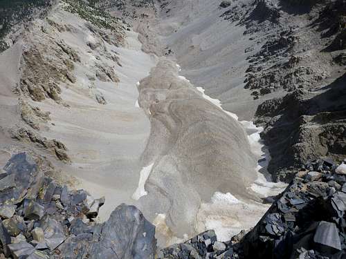
![Ice Core]() Shows a photo of ice at the core of an active rock glacier in Svalbard, Norway. The ice was located 100 cm down from the surface
Shows a photo of ice at the core of an active rock glacier in Svalbard, Norway. The ice was located 100 cm down from the surface What is a rock glacier? This term rock glacier is often thrown around loosely with little implication of the origin. This article is about rock glaciers, as you probably guessed. I wrote this as a report for one of my geology classes and have attempted to turn it into a readable article. By no means am I an expert in this topic, but I did spend a lot of time doing research on the topic meaning I should be somewhat knowledgeable in the topic. This article on rock glaciers is targeted towards the Southwestern United States, specifically the San Juan Mountains.
Terminology
Periglacial- Conditions that are seen with intense freeze and thaw cycles. These are most commonly seen in alpine or arctic environments.
Geomorphic/Geomorphology- Analysis of landforms and the processes that drive their creation.
Talus- large areas of angular fragmented rocks usually found in regions with high topographical relief.
Downslope- Direction of movement to lower elevations
Matrix- What holds fragments of rocks together
Permafrost- Areas in which seasonal fluctuations in temperature have no effect upon frozen ground.
Pleistocene- An Epoch in earths history that saw extensive glaciation some 10,000+ years ago
Intro
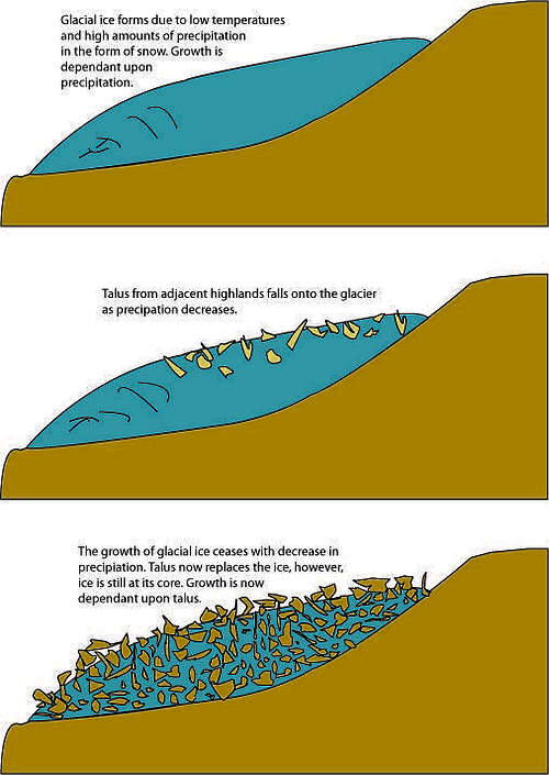
![Rock Glacier Illustration]() Typical formation of glacially derived rock glacier. alpine ice forms and becomes a glacier. Precipitation decreases and talus begins to fall on the rock glacier. Eventually, the glacier is entirely covered in talus due to a lack of precipitation, The ice effectively cements the glacier together with talus on top. Figure by author
Typical formation of glacially derived rock glacier. alpine ice forms and becomes a glacier. Precipitation decreases and talus begins to fall on the rock glacier. Eventually, the glacier is entirely covered in talus due to a lack of precipitation, The ice effectively cements the glacier together with talus on top. Figure by authorRock glaciers are talus fields of rock cemented in an ice matrix and generally form in mountainous areas characterized with high topographical relief. Rock glacier development can be related to the retreat of alpine glaciers or freeze thaw cycles causing ice to be inserted into the center of the rock glacier. Previous studies on rock glaciers are limited and most of this article will be devoted to the explanation of the processes involved in the formation of rock glaciers.
Types of Rock Glaciers
Glacial and Periglacial Rock Glaciers
Rock glaciers are aggregate of coarse rock fragments called talus in an ice matrix that accumulate and move downslope in an alpine environment. Unlike active glaciers that entirely consist of ice, rock glaciers require both talus and ice to contribute to growth. Mountainous regions supply large volumes of talus and are therefore the most ideal for rock glacier development. The best mountainous environment for rock glaciers is a continental setting characterized by low amounts of precipitation and mean annual temperatures at or 0 ℃. Rock glaciers are talus in an ice matrix that moves downslope under the effect of gravity . The ice in rock glaciers is dependent upon the permafrost. Whether or not they are glacially derived or periglacial rock glaciers, the rock glacier’s ice needs to be deep enough so that the active layer of permafrost has no effect on it. The active layer of permafrost is the depth of permafrost that thaws out with seasonal temperature fluctuations. Permafrost is a result of the periglacial process. The periglacial process in its simplest definition is the geomorphology cause by freezing cycles.
Glacial Rock Glaciers
Glacial rock glaciers were at one point active glaciers. These glaciers underwent ablation over a period of time and eventually, the decay of ice was replaced with input of talus and rock fragments from adjacent highlands. Ablation is the break-up of glaciers as a result of melting. Precipitation decreases while temperatures remain near 0℃. The glacier was reliant upon precipitation, but now it becomes reliant upon talus and is now morphed into a rock glacier.
Periglacial Rock Glaciers
Periglacial rock glaciers are fields of talus sourced from adjacent highlands that are formed from periglacial processes. The combination of intense freezing (frost) and the melting of snow cause the core of the rock glacier to develop ice as talus accumulates on top. Both types of rock glaciers appear physically the same. The main way to differentiate between the two is to examine the glacial history of the region or to map periglacial features to determine the extent (if any) of Pleistocene glaciation.
Tongue-Shaped and Lobate Rock Glaciers
There are two distinct physical types of rock glaciers; tongue-shaped and lobate. Tongue-shaped rock glaciers possess a greater length than width and are normally confined to narrow valleys or cirques. Talus is derived from steep and rocky highlands proximal to the head of the glacier. Lobate rock glaciers have a greater width than length. The talus source is derived from adjacent valley walls that enclose or encircle the lobate rock glacier. The talus contributes to a lobate rock glacier’s growth from multiple sides whereas the talus only contributes to the growth at the head of a tongue-shaped rock glacier.
![Sunshine Rock Glacier]() This photo shows a lobate rock glacier in the San Juan Mountains. Note how talus is sourced from adjacent highlands that surround the entire rock glaciers This photo shows a lobate rock glacier in the San Juan Mountains. Note how talus is sourced from adjacent highlands that surround the entire rock glaciers |
![Engineer Peak Rock Glacier]() This photo shows a tongue-shaped rock glacier in the San Juan Mountains. Note how talus is sourced from highlands adjacent to the head of the rock glacier This photo shows a tongue-shaped rock glacier in the San Juan Mountains. Note how talus is sourced from highlands adjacent to the head of the rock glacier |
Active, Inactive and Fossil Rock Glacier Forms
Rock glaciers can be categorized into three types based upon current conditions; active, inactive and fossil rock glaciers. Active rock glaciers possess deforming ice and have well pronounced ridges. The deforming ice is a result of downslope progression of the rock glacier. Active rock glaciers have a steep frontal slope that resembles a terminal moraine on a real glacier. Inactive rock glaciers possess many of the same characteristics with the major difference being the fact that they no long move downslope. The most prominent difference between active and inactive rock glaciers is that inactive rock glaciers have a gentler frontal slope. Fossil rock glaciers contain no ice and do not have any downslope movement. Fossil rock glaciers can be distinguished by vegetation and are geomorphically different due to the natural processes of weathering.
![Greg Topping Out]() Greg topping out on Dallas Peak with a view of the Dallas Peak rock glacier behind. This rock glacier has lower portions that are inactive and upper portions that are active.
Greg topping out on Dallas Peak with a view of the Dallas Peak rock glacier behind. This rock glacier has lower portions that are inactive and upper portions that are active. Controls on Rock Glacier Development
Topography
Topography plays a role in the development of rock glaciers. Rock glaciers require talus for their growth and the talus needs to come from adjacent highlands. Normal glaciers are a geomorphic agent that carve out valleys and scours in rocks which creates highlands. These valleys and cirques can be elevated in proximal locations to the rock glaciers and consequently generate talus. Mountain ranges with high relief naturally shed talus downslope. Some ranges are composed of rock types more subject to rock glacier development due to their resistance to weathering. Rocks more resistant to weathering will not generate as much talus as rocks that are easily weathered. Talus production is the first step in the transport of sediments from high reaches to lower fluvial and basin systems. Talus needs to remain stationary for many years to form a rock glacier. Given the right conditions any rock type will generate talus and many will erode faster once they become talus. Rock glaciers require a direct, continuous supply of locally sourced talus and must be elevated relative to the head of the rock glacier.
![Wheeler Peak Rock Glacier]() The Wheeler Peak rock glacier. Extreme vertical relief and vast amounts of talus make this a prime location for a rock glacier
The Wheeler Peak rock glacier. Extreme vertical relief and vast amounts of talus make this a prime location for a rock glacier
Climate
Climate directly controls the growth of rock glaciers. Ideal growth conditions for a rock glacier are characterized by mean annual temperatures below 0℃. These temperature conditions are required for active ice glacier and rock glacier growth, but precipitation rates differ. In Rocky Mountain National Park, rock glaciers are proximal to active ice glaciers. The main reason for this proximity is due to slope aspect. Wind loading of snow and lack of sun exposure allow for more snow to be deposited, resulting in the formation of ice glaciers. In the continental margins of the lower 48 states, this ideal slope aspect tends to be on north to northeast facing cirques and valleys. Areas that lack ice glaciers but have rock glaciers are characterized by mean annual temperatures near 0℃ but do not have high enough precipitation rates to produce ice glaciers.
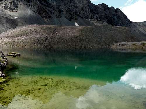
![Morning Reflection]() The Gilpin Peak rock glacier with Mt. Sneffels behind. This rock glacier is found in a continental mountain environment characterized by low amounts of precipitation and cold temperatures
The Gilpin Peak rock glacier with Mt. Sneffels behind. This rock glacier is found in a continental mountain environment characterized by low amounts of precipitation and cold temperatures
Geography
Rock glacier growth is a function of elevation. Rock glaciers occur at elevations above 3,670 m in the southwest United States. Glacial ice often occurs in mountainous regions in northern latitudes at similar altitudes. A mountainous region’s ability to produce glaciers is dependent upon its climate, which is in turn a function of its geographic location. For example, the Cascade Range in the Pacific Northwest of the United States is an ideal environment for ice glaciers due to its high annual precipitation. Therefore, this environment is not conducive to the formation of rock glaciers.
![Sloan Lake Rock Glacier]() Sloan Lake rock glacier as seen on the approach to Handies Peak. This rock glacier is most likely glacially derivived because of the immense amount glacial features present around this rock glacier. It is in a geographic location that is conducive to the formation of rock glaciers.
Sloan Lake rock glacier as seen on the approach to Handies Peak. This rock glacier is most likely glacially derivived because of the immense amount glacial features present around this rock glacier. It is in a geographic location that is conducive to the formation of rock glaciers.Analysis of Rock Glaciers of the Mount Sneffels Region
Now that we know about the processes involved in the formation of rock glaciers, lets look at four of them in the San Juan Mountains, specifically the Mt. Sneffels Region.
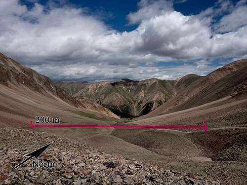
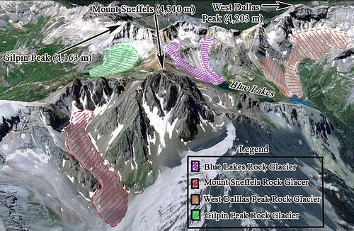
![Mt Sneffels Rock Glaciers]() The area receives 400 cm of annual snow fall and a mean annual temperature of 3.3 ℃. The study area is entirely contained in an elevation greater than 3,290 m. The main rock type in the area is low-grade metamorphosed rhyolite based on preliminary field observations. The San Juan Mountains are characterized by high topographic relief between peaks and saddles. These characteristics provide the study area with the two main conditions for rock glacier formation. Four rock glaciers will be identified and characterized based on climate, topography and geography. These rock glaciers are the Mount Sneffels, Gilpin Peak, West Dallas Peak and Blue Lakes Rock Glaciers. These names were applied to these landforms on the basis of named locations of proximal landmarks.
The area receives 400 cm of annual snow fall and a mean annual temperature of 3.3 ℃. The study area is entirely contained in an elevation greater than 3,290 m. The main rock type in the area is low-grade metamorphosed rhyolite based on preliminary field observations. The San Juan Mountains are characterized by high topographic relief between peaks and saddles. These characteristics provide the study area with the two main conditions for rock glacier formation. Four rock glaciers will be identified and characterized based on climate, topography and geography. These rock glaciers are the Mount Sneffels, Gilpin Peak, West Dallas Peak and Blue Lakes Rock Glaciers. These names were applied to these landforms on the basis of named locations of proximal landmarks.
![Mt Sneffels Rock Glacier]() Sneffels Rock Glacier originates on the north face of a minor peak east of Mount Sneffels. It begins below a very steep headwall at 3,888 m and ends around 3,440 m. It is 1000 m long and 188 m wide. Below the headwall, large snowfields persist annually due to the limited exposure to sunlight. The large volumes of talus in the region and lack of glacial landforms proximal to the rock glacier suggest a periglacial origin. The snowfield at the glacier’s head provides ice to cement the rock glacier together, while the talus above increases the volume of the rock glacier. This is the longest continuous rock glacier in the study area. The steep frontal slope at its terminus suggests it is a tongue-shaped rock glacier that is active Sneffels Rock Glacier originates on the north face of a minor peak east of Mount Sneffels. It begins below a very steep headwall at 3,888 m and ends around 3,440 m. It is 1000 m long and 188 m wide. Below the headwall, large snowfields persist annually due to the limited exposure to sunlight. The large volumes of talus in the region and lack of glacial landforms proximal to the rock glacier suggest a periglacial origin. The snowfield at the glacier’s head provides ice to cement the rock glacier together, while the talus above increases the volume of the rock glacier. This is the longest continuous rock glacier in the study area. The steep frontal slope at its terminus suggests it is a tongue-shaped rock glacier that is active |
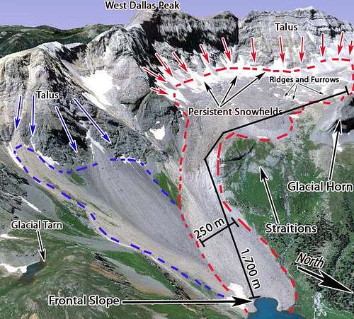
![Dallas Peak Rock Glacier]() The Dallas Peak Rock Glacier originates 3,942 m and ends at 3,342 m. This is a very large rock glacier that has two fingers that coalesce around 3,400 m. It is 1,700 m long and 500 m wide at its widest section. Both fingers originate from steep, north-facing headwalls and persistent snow fields. The lacks of glacial landforms suggest that the eastern finger is periglacially derived. Based on the presence of glacial landforms, the western finger is glacially derived. These glacial landforms include tarns, glacial erratics, and horns. The majority of the rock glacier is inactive and possibly in fossil form, below 3,500 m but the upper sections of the west part is active. The rock glacier as a whole is tongue-shaped, but the active upper west finger is lobate. Talus is sourced from the long west ridge from Dallas Peak and from adjacent Peak T0. Many snow fields persist below these headwalls, making this location an ideal for rock glacier development. The Dallas Peak Rock Glacier originates 3,942 m and ends at 3,342 m. This is a very large rock glacier that has two fingers that coalesce around 3,400 m. It is 1,700 m long and 500 m wide at its widest section. Both fingers originate from steep, north-facing headwalls and persistent snow fields. The lacks of glacial landforms suggest that the eastern finger is periglacially derived. Based on the presence of glacial landforms, the western finger is glacially derived. These glacial landforms include tarns, glacial erratics, and horns. The majority of the rock glacier is inactive and possibly in fossil form, below 3,500 m but the upper sections of the west part is active. The rock glacier as a whole is tongue-shaped, but the active upper west finger is lobate. Talus is sourced from the long west ridge from Dallas Peak and from adjacent Peak T0. Many snow fields persist below these headwalls, making this location an ideal for rock glacier development. |
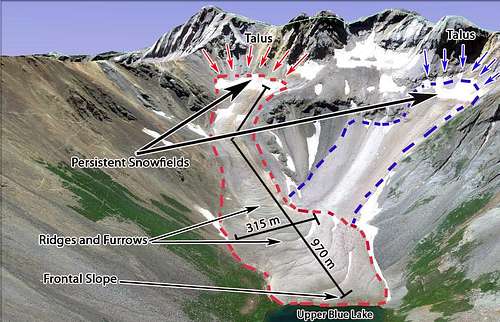
![Blue Lakes Rock Glacier]() The Blue Lakes Rock Glacier originates on a cirque north of Gilpin Peak. The highest reach of the rock glacier begins at 4,000 m and ends at 3,522 m. This rock glacier is composed of two rock glaciers that coalesce above the Upper Blue Lake at 3,665 m. Due to its dimensions (see Fig. 6), it is classified as a tongue-shaped rock glacier. The talus is supplied from the steep, north-facing headwalls of a minor summit north of Gilpin Peak. In the location where the two arms of the rock glacier begin, there are large, seasonal snowfields which provide the necessary ice to cement the rock glacier together. The Blue Lakes region is glacial in origin and it is possible that these rock glaciers began with the retreat of ice glaciers of the Pleistocene Era. Without field research, it is impossible to determine if this rock glacier is active or not. Satellite imagery shows a lack of vegetation, ridges, creases and a steep, frontal slope at the terminus of the rock glacier. These observations suggest that the Blue Lake Rock Glacier is an active, glacially derived rock glacier that is now being subjected to periglacial processes. The Blue Lake Rock Glacier is dependent upon seasonal snowfields due to the lack of glacial ice. The Blue Lakes Rock Glacier originates on a cirque north of Gilpin Peak. The highest reach of the rock glacier begins at 4,000 m and ends at 3,522 m. This rock glacier is composed of two rock glaciers that coalesce above the Upper Blue Lake at 3,665 m. Due to its dimensions (see Fig. 6), it is classified as a tongue-shaped rock glacier. The talus is supplied from the steep, north-facing headwalls of a minor summit north of Gilpin Peak. In the location where the two arms of the rock glacier begin, there are large, seasonal snowfields which provide the necessary ice to cement the rock glacier together. The Blue Lakes region is glacial in origin and it is possible that these rock glaciers began with the retreat of ice glaciers of the Pleistocene Era. Without field research, it is impossible to determine if this rock glacier is active or not. Satellite imagery shows a lack of vegetation, ridges, creases and a steep, frontal slope at the terminus of the rock glacier. These observations suggest that the Blue Lake Rock Glacier is an active, glacially derived rock glacier that is now being subjected to periglacial processes. The Blue Lake Rock Glacier is dependent upon seasonal snowfields due to the lack of glacial ice. |
![Gilpin Peak Rock Glacier]() The Gilpin Peak Rock Glacier originates around 3,926 m and ends at 3,734 m. It is 700 m long and 600 m wide. Talus is sourced from a wide area at the glaciers head from steep north facing headwalls on Gilpin Peak. Like the aforementioned rock glaciers, permanent snow fields reside at its head. Due to the presence of glacial landforms, it is glacially derived. Similar to all glacially derived rock glaciers in the region, the periglacial process now influences the rock glacier’s growth. Due to the rock glacier’s well pronounced furrows and frontal slope, this rock glacier is the best representation of rock glacier morphology in the study area . It is a lobate rock glacier because it is almost as wide as it is long. The Gilpin Peak Rock Glacier originates around 3,926 m and ends at 3,734 m. It is 700 m long and 600 m wide. Talus is sourced from a wide area at the glaciers head from steep north facing headwalls on Gilpin Peak. Like the aforementioned rock glaciers, permanent snow fields reside at its head. Due to the presence of glacial landforms, it is glacially derived. Similar to all glacially derived rock glaciers in the region, the periglacial process now influences the rock glacier’s growth. Due to the rock glacier’s well pronounced furrows and frontal slope, this rock glacier is the best representation of rock glacier morphology in the study area . It is a lobate rock glacier because it is almost as wide as it is long. |
Final Remarks
Discussion
Much of these results were based on speculation, extrapolation from other studies and real time data used from digital imagery. With regard to active or inactive forms, it is nearly impossible to determine whether or not a rock glacier is active, inactive or in fossil form by simple visual analysis of morphology. Morphological analysis, in combination with core analysis and ground penetrating radar (GPR) are ideal methods for determining rock glacier characteristics. Core analysis is often impractical for rock glacier analysis, due to the logistics involved with transporting the associated drilling equipment past treeline. GPR has not been used in the region, but this is the cheapest and most convenient method for determining the core of the rock glacier.
CONCLUSIONS
Talus is a function of the amount, type and source of rock fragments. These conditions vary in different regions and in the Mount Sneffels region, these conditions are found on north to north east facing aspects with elevations in excess of 3,400 m. Large snowfields persist at the head of all the rock glaciers in the study area. These snowfields exist due to the fact they receive minimal amounts of sun exposure and increased snowpack due to natural avalanches and wind loading of snow. This setting has just the right amount of talus input due to poor rock quality and proximity to highlands. The study area, when analyzing similar regions in Colorado, possesses an abnormally high amount of rock glaciers which leads the observer to believe that this setting is highly conducive for periglacial rock glacier development.
Closing
I hope you enjoyed this read! Writing about this topic really helped me learn about rock glaciers myself.


Comments
Post a Comment