
|
|
Mountain/Rock |
|---|---|
|
|
39.97540°N / 106.0004°W |
|
|
Grand |
|
|
Hiking, Mountaineering, Skiing |
|
|
Spring, Summer, Fall, Winter |
|
|
10620 ft / 3237 m |
|
|
Overview
White Cliffs Peak is one of those mountains that many people view, but few make the effort to climb. Because of the highly visible cliff face, the peak is very conspicuous when viewed from the west or from the north, but from the south or east the peak takes on a more unassuming nature.Perhaps one reason that relatively few people make the climb is because it’s a long walk on an old logging road to the north slopes of the mountain. The old logging road is closed to motor vehicles, but mountain bikes are allowed to use it, which can save several hours of walking the old road if you are so inclined. Once at the northern base of the mountain it’s a fairly quick hike to the summit.
The peak has some spectacular views and the cliff face is interesting, so this is a worthwhile climb.
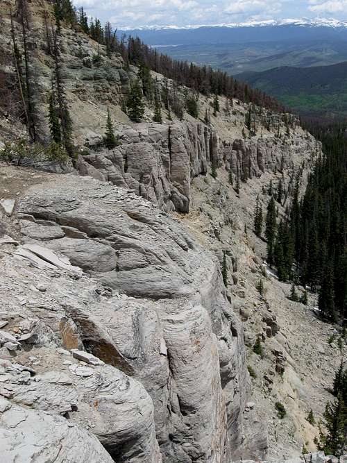 These are the White Cliffs as viewed from the summit of White Cliffs Peak.
Getting There
From Highway 40 between Granby and Tabernash and between mile markers 216 and 217, turn west on County Road 55. Follow this good gravel road for 5.4 miles to the top of Cottonwood Pass and turn south (left) onto County Road 555. Follow this road for 3.1 miles and to a 3-way junction. The beginning of the hike is the gated road on the left. Park here.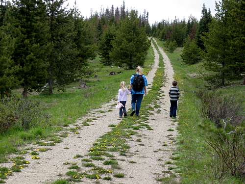 Part of the old logging road near the trailhead.
Routes Overview
Blue Ridge RouteThe only access route that I am familiar with is the Blue Ridge, which is the long ridge extending north from White Cliffs Peak. It is likely by far the best route to climb the peak.
This route is easy and long and follows old logging roads for much of its distance. The last part of the climb has no real trail, but cross country travel is easy. Even though much of the route follows an old and closed road, there are many viewpoints along the way making it a worthwhile route.
This route is 11 miles round trip and has a total of 2200 feet elevation gain.
 This is the final ridge up White Cliffs Peak.
Other Routes
White Cliffs Peak could be climbed from the west or from the south and from County Road , but I am not familiar with the route. There is no trail from that direction, but the forest in these parts seems mostly open or at least the brush isn’t thick enough to make it a miserable bushwhack. The mountain is also fairly steep from that side.
Routes up the peak from the east are probably blocked by private land and routes from that direction are not recommended.
The White Cliffs themselves are made of loose and crumbly rock and are not suitable for rock climbing.
Red Tape
No permits are required.Camping
There are excellent undeveloped campsites at the trailhead. There are also campsites along the Blue Ridge Route if you feel inclined to make it into an overnighter, but be aware that in late summer there might not be much water around. We found plenty of streams in mid-June.When to Climb
White Cliffs Peak can be climbed year round.Mid-June through sometime in October might be considered the normal time of year to climb the mountain. This is a good early season peak to try when the higher surrounding mountains are still snowed in.
This peak would a very safe winter ascent, but it may be a long walk to the summit if the road to Cottonwood Pass is not open. Inquire locally on road conditions.
 Near the summit of White Cliffs Peak on June 13 2009.
Mountain Conditions
For current road and trail conditions, contact:Sulphur Ranger District
9 Ten Mile Drive
Granby, CO 80446
970-887-4100
WEATHER FORECAST
Below is the climate summary for nearby Berthoud Pass at 11,315 feet elevation. These are all averages, so expect more variation, but this will give you a good idea about the climate at higher elevations around White Cliffs Peak. *National Weather Service Data 1950-1985.
| MONTH | HIGH | LOW | SNOW DEPTH | DAYS W/PRECIP |
| JAN | 21 | 1 | 42" | 19 |
| FEB | 24 | 2 | 52" | 16 |
| MAR | 29 | 6 | 63" | 20 |
| APR | 36 | 14 | 67" | 17 |
| MAY | 45 | 23 | 53" | 16 |
| JUN | 54 | 32 | 17" | 11 |
| JUL | 62 | 39 | 0 | 14 |
| AUG | 60 | 38 | 0 | 14 |
| SEP | 53 | 31 | 0 | 11 |
| OCT | 42 | 21 | 3" | 10 |
| NOV | 30 | 10 | 14" | 15 |
| DEC | 23 | 3 | 29" | 18 |