|
|
Mountain/Rock |
|---|---|
|
|
40.73400°N / 110.4367°W |
|
|
Duchesne |
|
|
Hiking |
|
|
Fall |
|
|
11884 ft / 3622 m |
|
|
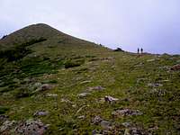
 Yellow Benchmark viewed from the north
Overview
Yellow Benchmark (11884') lies on the south slope of the Uinta Mountains of Utah. It and its smaller neighbor (11412') form the dividing line between the Garfield Creek drainage and the Yellowstone Creek drainage. As the crow flies, it is 4.6 miles southwest of Kings Peak, Utah's highpoint. It is ringed by numerous 12 and 13 thousand footers and provides excellent views of them all. Counterclockwise, these are Bluebell Lake Peak, Stone BM, S Porcupine, Porcupine, Wilson, E Wilson, Powell, Henrys Fork, S Kings, Painter, Trail Rider, N and S Timothy Peaks, Bluebell Pass Peak, and Paul BM. Yellow BM on the right, Porcupine, Wilson, and E Wilson in the background
Although Yellow Benchmark is not particularly tall or rugged compared to nearby peaks, it has a feature few other Uinta peaks share. It really stands out.
 Yellow BM in front of Mount Powell
 From the east From the east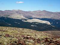 From the west From the westIn a sea of reds and greys, you can see it shimmering bright gold from miles away. It is not merely another in a string of bumps on a ridge like almost every other peak in the High Uintas. Yellow BM and 11412 appear to rise up by themselves from the valley floor, unconnected to anything. |
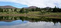
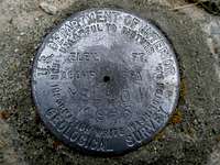 The benchmark The benchmarkThe summit of Yellow BM is fairly flat but has two small bumps as is evident on the topo map. The northern one is the actual highpoint and the southern one contains the benchmark. The map says the benchmark is at 11884', but my GPS recorded 11920 at the benchmark and 11931 at the summit. Like many Uinta peaks, the southern of the summits has several clefts. These are not nearly as deep as you usually see, being only about 4'. On other peaks, they are easily 3 times that. It is difficult to imagine this peak being climbed very often, yet it affords stunning views, is not a difficult hike (although long), and is suitable for a family backpacking trip. There were lots of fisherman in Garfield Basin, but not surprisingly, we were the only ones on the peak. Getting There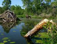 Beaver pond on the way to the trailhead Beaver pond on the way to the trailheadThe shortest access is via the Center Park Trailhead. See the Driving Directions section for directions. Red Tape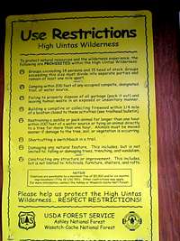 The scoop The scoopCheck the sign board at the trail head for specific details, but in general, you may not build a fire within a quarter mile from any of the major lakes and you must camp 200 feet away from the trail, any water source, or another established camp. Camping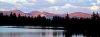 A small lake in Garfield Basin A small lake in Garfield BasinThere are 5 established campgrounds near the Center Park Trailhead as described in the trailhead page camping section. There are numerous places to camp in Garfield Basin. Water is plentiful. But, as mentioned in the Red Tape section, please check the sign board for proximity restrictions to lakes. When to Climb
The best window of opportunity is late June through the beginning of October. Routes
Garfield Basin Trail
Mountain Weather Yellow BM in the center Yellow BM in the centerHere is a link to the current 7 day forecast for Yellow Benchmark. It rains frequently in the Uintas. Map |