
-
 12731 Hits
-
 93.58% Score
-
 43 Votes
|
|
Mountain/Rock |
|---|---|
|
|
44.52230°N / 113.5188°W |
|
|
Lemhi |
|
|
Hiking, Scrambling |
|
|
10968 ft / 3343 m |
|
|
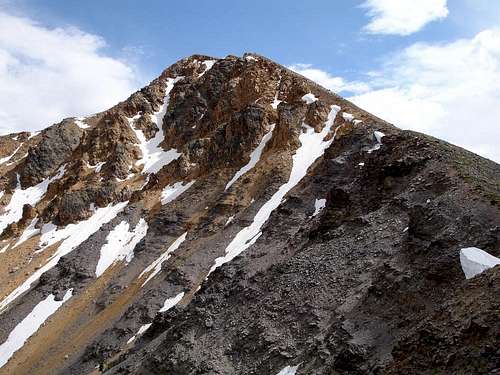 Northeast Face
Overview
Yellow Peak is an eye-catching mountain located near the center of eastern Idaho’s remote Lemhi Range. The Lemhis are generally made up of a linear string of peaks. But to the north, the range becomes broader and more complex as ridges branch off in various directions away from the main Lemhi crest. Yellow Peak lies in the center of this widest portion of the Lemhis. It is a peak that seems to call you to its summit. When you see it, you just want to climb it. Part of this appeal is probably due to the unique yellow tint and attractive pyramidal shape, but there’s something more. It’s hard to explain, but easy to understand if you see the peak in person.The mountain gets it’s color from a high concentration of yellow quartzite that is abundant on the peak. The rock is present on all aspects of the mountain, but it is most prevalent on the peak’s steep northeast face. The yellow color is also visible along the ridgeline connecting to Junction Peak to the east. Other than adjacent Junction Peak, all other mountains in the area are made up of much darker sedimentary rock.
Like most of the mountains in the seldom-visited Lemhi Range, Yellow Peak isn’t climbed very often. But it does receive more visitors than most peaks in the vicinity. Yellow Peak pretty much dominates the local terrain when viewed from the many hiking trails used to access the area. This dominance is a result of the peak’s striking yellow color and distinctive shape.
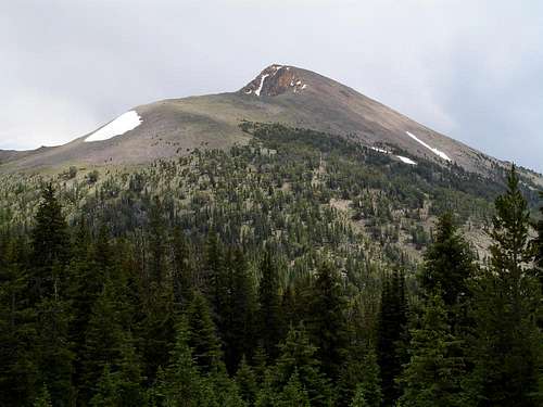 Yellow Peak
On the Summit
There are three separate summit cairns on top of Yellow Peak. One lies at the northern end of the summit ridge, one at the southern end, and another right in the middle. This middle cairn is the highpoint by a lean margin and is home to the 1956 USGS benchmark. The northernmost cairn is the best vantage point to peer down the steep northeast face into the Rocky Creek drainage. It also offers the best view of the lush “Park Fork of Big Creek” area to the northwest. The southern cairn is the best position to check out the Big Timber Creek area as well as nearby 11ers Flatiron Mountain (11019’) and Big Creek Peak (11350’) to the south. Farther off in the distance, much of the Lost River Range can be seen to the west, with the Beaverhead Mountains visible beyond the Lemhi Valley to the east.
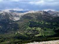 Park Fork Park Fork |
 Junction Peak Junction Peak |
 11ers to the South 11ers to the South |
Getting There
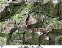 Trail Map
Because of the remoteness of the Lemhi Range, reaching a trailhead to access Yellow peak generally involves a long drive through some of Idaho’s most uninhabited areas. Each of the east side approaches listed below require you to reach the small town of Leadore (population 90) home to a gas station, small store, and a couple cafes. From Leadore, take the paved Lee Creek road heading west from the center of town.
For the west side approach to primitive Big Creek Campground, make your way to the small community of Howe then head north through the Little Lost River valley to the Pahsimeroi Valley, continuing until you reach the signed turnoff for Big Creek. This junction is about 50 miles north of Howe.
Yellow Peak is centrally located within a large wild area that is void of roads, but home to an abundance of trails. Each of the route options below have the potential to link up with other trails in the vicinity to form a longer multi-day loops for backpackers who are interested in exploring more of the area. All of the trails listed here are open to motorcycles, but usage is low so trails are still very hikeable.
| Route | Description | Trailhead (Topozone Link) |
Mileage (One Way) |
Gain |
| Middle Fk Little Timber Cr | Probably the best route for a singe day outing. Easy access to both the north and west ridges of Yellow Peak. Approach is from the east. | Middle Fk Little Timber Cr TH | 5.7 | 3300' |
| Park Fork Big Creek | This is the most likely approach from the west side of the Lemhis. Could return to the trailhead via the Snowbank Trail and create a 35+ mile loop. | Big Creek CG | 11.7 | 4400' |
| Big Timber Creek | This east side approach follows the Big Timber Creek trail all the way to the saddle on the peak’s west ridge (Yellow Pass). The first half of the hike is pretty flat, with the majority of the gain coming in the last four miles. | Big Timber Creek TH | 11.2 | 3700' |
| Rocky Creek | Shortest route from the Big Timber Creek trailhead, also provides easy access to both the north and west ridges of the peak | Big Timber Creek TH | 8.8 | 3700' |
Camping
Camping is available at all three of the trailheads listed above. Most of the routes are conducive to a multi-day trip. If this is your game plan, then great campsites can be found at the small lakes near the saddle on the peak’s west ridge or a various other points along the trails. The secluded off-trail “Park Fork Lake” is also a nice option, but you must be prepared to invest in some route finding to reach it. Park Fork Lake
Red Tape
No red tape, trailhead passes, or other paperwork to worry about in the Lemhis.When to Climb
Typical summer climbing season in the Lemhi's is from early July until the snow flies sometime in October. The earlier you go, the more likely you are to encounter more difficult stream crossings, so be prepared. The flow of snow water run-off generally drops off by mid July.Mountain Conditions
- Leadore Ranger District - Contact Info for the nearest Forest Service Office.
- NOAA Pinpoint Forecast – Weather.
- Idaho Outdoors Forum – Message board monitored by many local climbers.
Guidebooks
Despite the remote nature of the Lemhis, there are actually a few guidebooks with details on the area. Below are a couple that contain useful information.- Idaho: A Climbing Guide by Tom Lopez – This is far and away the premier mountaineering text for the state, including details on Yellow Peak and others in the vicinity.

- Trails of Eastern Idaho by Margaret Fuller and Jerry Painter – Lots of detailed route descriptions for the eastern part of the state, with information on trails in the area surrounding Yellow Peak.
