Exposition
My hiker-friend Daniel is the official high pointer. I'm just going along for the ride, I tell him. I take whatever comes, and while I love mountaineering, I do not set state high point goals for myself out of reason that, well, most of them really aren’t that special. A lot of them seem to be merely tracts of land indistinguishable from the surrounding countryside.
Example: I was driving through Nebraska (the Feedlot State) a few weeks ago, whereupon looking at the map, noticed I-80 was relatively close to Panorama Point, the state high point. Did I stop? No, because I knew it was nothing remarkable (sorry). Later I found out the owners whose property the high point is on charge a fee to visit it. Why pay $3 to see what had been boring me for the last six hours? While I suppose this could illustrate my incredible monetary pettiness when it comes to such matters, it merely serves to reflect my attitude toward the high points of ephemeral political boundaries. Regardless, Daniel was disappointed to learn I didn’t visit it given the chance.
![Panorama Point, Nebraska]() Panorama Point: photo courtesy of shmeyers21
Panorama Point: photo courtesy of shmeyers21
Anywho, the basic facts of this trip are as follows:
1) I was researching grad schools of sorts, and found an appropriate one in Salt Lake City.
2) Daniel happens to live just north of said metropolis.
3) I flew out to Utah on July 12, crashed at Daniel’s house, and visited the school on Monday. Daniel informed me that he was looking for a partner to hike Borah with him the following day, so that he could bag another high point. Would I care to join?
4) YES!
Road Trip
Except for the fact that it was Idaho’s high point, I knew zilch about the mountain. Forget about location, elevation or vertical rise, hell, I wasn’t even sure as how to spell it, or how it acquired its name.* Perhaps not my wisest moment, but hey, capriciousness is part of life.
We planned on waking at 6:00 am to begin the drive. We woke at 7:00. No big deal. Before we left we ate breakfast (cereal). Then we stopped at the Wal(star)Mart so Daniel could buy black and white film for his camera and an adapter for his iPod. Then we fueled up on go-go juice.
![Idaho]() Land of Opportunity
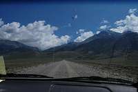
Land of OpportunityWe were finally on the road for good around 8:30 or so. A little late, perhaps, but at least there wasn’t any traffic. We plugged the adapter into the cassette deck, poised to hear Eddie Vedder’s golden baritone erupt from the speakers. No such luck; the car rejected the cassette. We tried a few more times. No dice. We settled for NPR and later some lame rock stations.
Because Daniel drives at about 90 mph, it didn't take long to cross into the Gem State. I had never been to Idaho before, and it seemed even emptier than Utah. When I rolled down the window, the scent of sagebrush overwhelmed my olfactory receptors. We passed through few towns along the way, all of them seemingly stuck in a time that was not the present. Like something from a Jack Finney story.
![Birch Springs Road]() Birch Springs Road
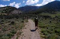
Birch Springs RoadSome time before noon we pulled onto the dusty Birch Springs Road, which connects to the trailhead from US 93. Only a few vehicles were in the parking lot. We gathered our minimal gear, paid a visit to the nearby outhouse and talked with a dude who had arrived shortly after us and was training for a trip to the Tetons. He had never been up the mountain before, so we couldn’t really offer each other any advice. He was still putting on his large leather boots when we started up the trail at 12:15 pm.
*Of course it's named for some dead white guy who served in the U.S. Senate for 100 years or something. Figures.
Ascent
Now the signs at the entrance-stile noted it took the average person anywhere from 10- 12 hours to hike up and down Borah in a given day. Seeing that the trail was only 3.5 miles in length, we let hubris assure us that our healthy, young bodies would have little difficulty in beating that time.
And the first two miles of the climb were really quite undemanding. The trail seemed rather well maintained, and it was mostly shady, with few spots exposed to the sun. The pitch was steep, but this wasn’t the least bit surprising considering there was a punishing full mile of vertical relief from the trailhead to the summit. Yet we were able maintain a pretty steady pace, halting only for some photo opportunities and one real break of any significance to catch our breath. Up until this trip I had been running upwards of 50 miles a week for a marathon in October, and was feeling more fit than usual. Still, being a flatlander from Long Island, I wasn’t used to the elevation, and could feel the thinness of the air as we ascended.
![Daniel walkin toward stile]()
Nearing the first false summit above the timberline, we spotted a figure heading toward us, our first hiker of the day. It turned out to be a very robust, older gentleman dressed in jeans and a t-shirt but with no gear whatsoever. Not even a water bottle, which kinda surprised me given that up until now there was absolutely no water on the trail, the air was very dry, and the temperature quite warm. As we approached each other, we offered our salutations. Daniel, ever-inquisitive, asked for his age.
“67.”
And how did he keep in shape?
“Climbing mountains.”
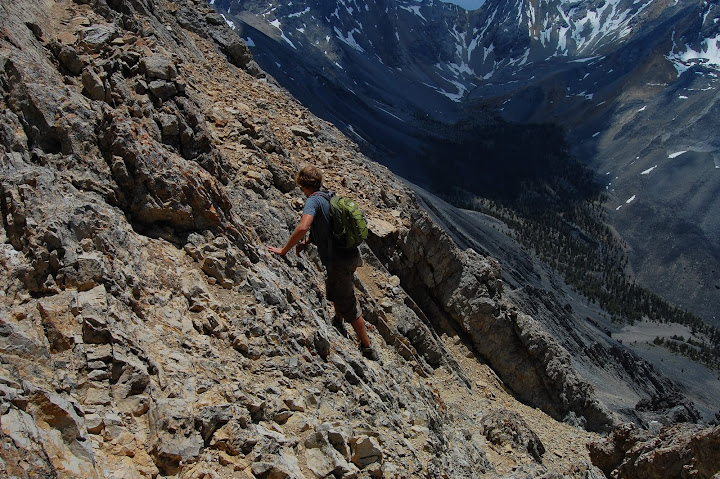
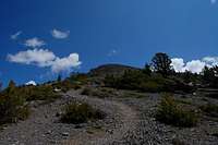
It wasn’t too much longer before we were within full sight of the rest of our route. We were now climbing up a broad, talus-strewn ridge that swung in a southeasterly direction toward the summit. Up ahead was Chicken Out Ridge, the knife-edge that we would have to traverse in order to reach Idaho’s apex.
We began spotting snow on the slopes of the ridge we were walking on, and after some more pictures and a few snowball fights, we happened across three more hikers heading down, two of whom stopped to chat with us for a while. These guys, who looked to be pretty experienced mountaineers (they carried full backpacks complete with trekking poles), told us they began hiking at 6:00 am - I wasn’t even awake at that time! It was now a little after 2:00 pm. They informed us there were a few snowbridges up ahead and that we were maybe an hour from the summit.
As we finished up our chat with the friendly hikers, we spotted our friend from the parking lot about a mile behind us, walking along the plateau. We wouldn’t see him again.
At this point we were well over 11,000 feet, probably approaching 12,000, but it was hard for me to say for sure. The air was certainly thin, and Daniel, who had lived at 4,000 ft his entire life and was more used to the altitude (in addition to having much more upper body strength) powered ahead of me as we climbed up the ridge. The technicality of the scramble forced me to put my camera away for the time being and I slowly climbed hand over hand over the exposed ridge, thankful for the near-stillness of the wind and the cloudless day.
Climbing up the ridge proved to be only a minor problem; it was descending the 20 foot notch afterward that required more creativity. Daniel waited up for me and didn’t continue along the snowbridge until I managed to safely scramble to the foot of the notch and to the edge of the snowbridge.
The snowbridge looked a lot scarier than it actually was. It was quite narrow, and there were a few paths of footprints below the top bridge that a few shaken souls undoubtedly thought was safer. At first glance I regretted not bringing some sort of hiking pole or ice axe, but the snow was soft (but not too soft!) and held us firmly as we crossed with relative ease.
Summit!
![Glory]() The hills are alive with the sound of... farting.
The hills are alive with the sound of... farting.
After some more trickiness and another shorter snowbridge, the trailed leveled out once more along the side of a gigantic, steep, scree-filled slope toward the final knife edge, which proved to be even scarier than COR.
![Summit from below]() Almost there
Almost thereDaniel, of course, was way ahead of me at this point, and the only real way up the ridge seemed to be at the edge near the foot drop-off. I could see several deep blue, snow-laden tarns resting in the notches 1000 feet below. But the drop-off was very unnerving, and I spent a good 10 minutes trying to find a more reasonable way upward. This proved to be fruitless, as all the good protrusions were too far apart for my 5’5” frame to grasp securely. Eventually I made my way back to the edge of the cliff and tentatively climbed toward the summit.
![Tarns]() Tarns
Tarns
The last 50 yards of the ridge were flatter and more secure, and I was just below the lip when I heard a loud “whoop!” an indication that Daniel had reached the summit and bagged his 13th high point.
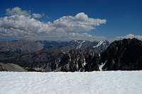
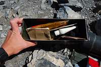
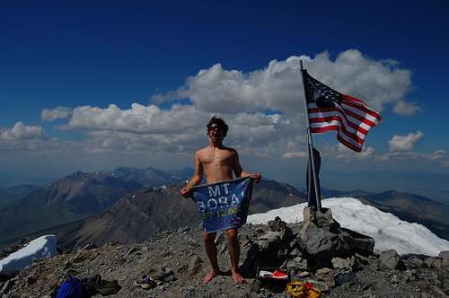
I reached the summit a few minutes later, roughly 3.5 hours since the start of the hike, and basked in the glory of the adventure. We were in a true wilderness area; in fact the whole Lost River Range had a Swiss Alps feel to it, except there was an American and Idaho state flag here at the top. At the flag pole’s base we found an artillery box filled with all sorts of crap, including several tattered registers, some unopened freeze dried food, a few basic medical supplies, and other
WEIRD* knickknacks.
There was also a cylindrical tube housing what seemed to be a homemade banner proclaiming “MT. BORAH ELEV. 12,662 FT 2009.” According to Daniel, Idahoans are really into homemade things.
*Daniel's emphasis
![Le summit]() Naked?
Naked?Descent
We spent about half an hour up top before heading down. It was now well past 4:00 pm, and time to get back to the parking lot before the sun set, as we didn’t have our headlamps.
The knife edge again proved to be a trying task—climbing up was much easier, and it took me a good 20 minutes to finally make it to the bottom.
Walking over the snowbridges proved to be no problem, but climbing back up the notch on COR was somewhat tricky. Daniel and I decided that instead of climbing directly up the jagged face, we would climb around its south side and over it. In order to get around to the south face, we shimmied around the rock wall, avoiding the ice that was only a few inches from the footholds.
Once past COR, the rest of the hike down was pretty much a breeze. Below timberline the trail became much steeper, with very few switchbacks, and we were basically tumbling down, bleary with dehydration, into trees the entire time. We had finished our water long ago and the snow we scavenged from the summit was not melting fast enough to drink.
We made it back to the trailhead shortly before 7:00 pm, sunburnt and weary. No cars were in the parking lot, so it stood to reason that our friend must have “chickened out”. My legs felt like jell-o from the descent, and I somewhat regretted not bringing trekking poles, not that I even owned a pair anyway.
Borah proved to be a tougher hike than I anticipated, but the sense of accomplishment was very intrinsic and rewarding— a good feeling indeed. Bagging the bastard gave me a shot of endorphins that made me feel alive for the first time in a while.
Epilogue
Daniel and I each took lengthy chugs from the reserve jug of warm water we had left in the car and began the long drive back to Salt Lake City, stopping only for gas and dinner in Arco. The waitress at the burger joint was cute.
And now we’re friends with her on Facebook.


Comments
Post a Comment