
Viewing: 1-1 of 1
splattski - Jul 31, 2013 8:21 am - Voted 10/10
Great reportNicely done and useful. You should attach this to the Mt. Borah page.
Viewing: 1-1 of 1
If you've found this trip report, then chances are you already know all the basics of the climb, and you just want to hear another account of Chicken-out Ridge. I'll offer a teaser and come back to it later. To experienced climbers, I totally agree that COR "involves no technical climbing." To non-climbers lucky enough to have no fear of exposure, I totally get that climbing the standard route can be "a fun little scramble" (and I may have been in this camp in high school, but I'm half octogenarian now). To you, I say much respect. To those of you who go farther and say that COR is therefore "overrated" and "doable by anyone", I am compelled to adjudge you a complete dbag. Because for me, COR was a downright terrifying experience. And for my hiking friend, it was an experience he elected to forego.
* * *
My buddy and I left Boise mid-afternoon on Friday and made it to Mackay in about 3.5 hours. Stopped for an excellent burger and a couple of ales at a well-reviewed joint frequented by local ranchers and weekend adventurers (http://www.tripadvisor.com/Restaurant_Review-g35520-d1466147-Reviews-Ken_s_Club_Steak_House-Mackay_Idaho.html). For the twenty miles drive north from Mackay to the trailhead turnoff, we anxiously scanned the Lost River Range for the peak that would be our challenge. One of those big rocky peaks was Leatherman Peak, which yielded only to its neighbor Mount Borah, the highest peak in Idaho at 12,667 feet.
We pulled into the campground around 6pm. Having set the over-under on other hikers who beat us to camp at 7 vehicles, we were surprised to see a dozen cars, trucks, or RVs. By morning, there'd be well over 20. The 5 official campsites were full, but there was ample room in the area for another 15+ tents, and we set up in a fine spot overlooking the Lost River valley. Having added a half-Ambien, mooched from my friend, to a base of burger and beers, I had no trouble getting to bed early.
We woke up before 5am for a light breakfast and some coffee, the latter of which eventually had its intended weight-lightening effect. Back from the morning's deposit, we were hit with short heavy rain and fled to the car. Had we started 15 minutes earlier, I really would have been kicking myself for forgetting my rain shell. A few minutes later, we loaded up and hit the trail at 5:34am, with a first step on the trail at 7320 feet.
We started with headlamps on, but I took mine off when I realized that what must have been a very bright moon cast enough light through a lampshade of thin cloud cover to see the trail without the highbeams. The first part of the trail was not very steep, and we noted we chewed off the first mile in about 30 minutes. (This may sound slow, until you consider that the average round trip time is reportedly between 8 and 12 hours, and the trip to the summit variously measured between 2.8 and 3.5 miles.) From there, the trail turned up and slowed our pace considerably. We passed a couple of guys who were already taking a break from the 30+% grade. Although this busy day on the trail brought out trekkers of all shapes and sizes, one of these two guys appeared to be someone you'd think should never try this climb. But the moral of this story is that physical fitness is only half the game, and this guy was fearless. Because of his apparent desire to laugh death in the face, which I'll come to later, I'll refer to him respectfully as "Weeble Knievel! Idaho's own half-man, half-potato! Drinks a shot of straight danger with his morning Froot Loops! (nolongeradmittedintheintelligentdesignstatesof PennsyltuckyandMissahomaDoNOTtaunthappyfunball) or . . . just Weeb'.
Somewhere after 1.5 miles, the trail emerges from the trees and becomes rocky and loose. You're stopping to catch your breath more frequently now, and you notice that you're being harassed by mosquitoes at every break. As one teenager nearby wisely observed, "how can there be mosquitoes up here when there's no water within 3 miles of us?" Yeah, what he said, you bloodsucking b*stards.
Because of the light clouds and bright moon, the transition from night to day was gradual and imprecise. The temperature had been perfect so far, allowing comfort in shorts, a long-sleeved Icebreaker and light gloves. I started looking up more frequently to spot the beginning of COR. (NOTE: a few people used "Chicken-out Ridge" to refer only to the last down-climb to the snow-bridge , but most, including me here, refer to "Chicken-out Ridge" as the entire section of climbing/scrambling before the snow bridge.) I was not worried about the physical challenges of the day. Nor was my friend, who does marathons and ultra-runs with or without training. It was the uncertainty about how I'd do at exposure that led to mental mastication and brain bruxism. (Based on past experience, my chicken won't even bother coming out when bouldering around even 20-30 foot drops. But get me near 1000 feet of exposure, and my chicken goes effing headless.)
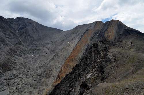
After a slow slog up some steepening scree, we found ourselves at the base of COR. Which "route" to take on COR is a subject of hot debate among regulars. (I put "route" in quotes, because frequently on COR it is simply invisible -- defined only by the fact that you just stepped there.) I'd say the consensus view is that you should take the "standard route", which is usually (but I believe not always) over the top of the knife's edge. Others say to "go left" (on the climb up) to go around the knife. One group of experienced trekkers -- who truthfully told me how much "fun" they had just had "playing" on the standard route -- told me that the "go around" route was so easy it was just a hike. It was a route they would only skip down if they got caught at the summit in a storm. Proponents of the standard route spit venom at the thought, and at least under the conditions of July 27th, 2013, declared the "go around" route "way too soft" to be safe. Here's a good image and description of the routes: https://www.summitpost.org/chicken-out-ridge-route-photo/686435.
Based on my internet research (and aided by the fact that I never saw where to pick up the "go around" route), I chose the standard route. But I definitely wanted to follow someone else's lead. After stowing my trekking poles, I mustered the courage to climb up the middle of the start to COR, where two guys were perched in a narrow gap in the rocks. Unfortunately these guys were coming down. Later I learned that this pair of tattooed tough-guys had "chickened out" shortly after they started COR. Glad I didn't know that at the time, or I might have followed them back down.
Soon another climber came up from behind, passed me, and at least acted as if he knew the route. Good enough for me. We started over the top, but then were forced around the right side. (Here's an old video that captures this section well, at around 2:00 - 2:50: http://vimeo.com/28537448. Although this clip of video captures accurately what I felt on this section, an objective observer might be right to conclude that the wide-angle lens makes the exposure look a little worse than it is.) I hurried to keep up with my makeshift guide, who started to gradually pull away. More scrambles over the top, where you can't see what's on the other side, but your peripheral vision can't miss occasional chutes into the void, whether real or imagined or somewhere in between. Where's that damned down-climb to the snow-bridge??? I was surprised how long COR was. This was no deal where you just get up your nerve, shimmy across a ledge, and be done with it. I estimate I was between 30-45 minutes on this cursed stretch. Probably a good thing I didn't know that before I started.
I popped up over another knife-ridge rock and could see my guide. Good news is that I was close to him now. Bad news is that he was either stuck or going very slowly. This must be the down-climb to the snow-bridge, a last obstacle that some people call simply "Chicken-out Ridge." I was prepared for the terror, but mostly glad to be near the end. As I approached the down-climb, my guide himself was being guided by a good Samaritan who waited on the snow-bridge to lend a hand. Here's a picture of the down-climb: https://www.google.com/imgres?q=%22chicken-out+ridge%22+snow+bridge&hl=en&biw=1065&bih=790&tbm=isch&tbnid=VObqkVsyypYu0M:&imgrefurl=http://picturesofcascade.com/viewlandmarks.php%3Fidnum%3D121&docid=Pi-C2mq1JArzSM&imgurl=http://picturesofcascade.com/large7/Borah-38L.jpg&w=1200&h=898&ei=gtP2UZi3CsG0iQLZh4DoBw&zoom=1&iact=rc&dur=390&page=2&tbnh=148&tbnw=214&start=24&ndsp=31&ved=1t:429,r:28,s:0,i:168&tx=129&ty=69
The good Samaritan must have sensed my desperation, because after guiding my guide, he stuck around for me too. He even asked me my name, like how an EMT might ask a victim's name to help ward off shock. With this great coaching (namely, to go the first third down the middle, then side-step to the crack to the right, and then down), I actually got down fairly quickly. I thanked anyone within yodeling range and clapped my hands in a wave of relief, as I shuffled across the snow-bridge. Here's a picture of a guy finishing the down-climb: https://www.google.com/imgres?q=%22chicken-out+ridge%22+snow+bridge&hl=en&biw=1065&bih=790&tbm=isch&tbnid=dlAAvT4wacYgGM:&imgrefurl=http://www.idahopress.com/blogs/2c_etc/i-conquered-mount-borah/article_d2239664-df0c-11e0-908f-001cc4c002e0.html%3Fmode%3Dimage%26photo%3D&docid=g6d41q8GaXU8AM&imgurl=http://bloximages.chicago2.vip.townnews.com/idahopress.com/content/tncms/assets/v3/editorial/0/6a/06a3bf3e-df0f-11e0-888e-001cc4c002e0/4e710c9d03000.image.jpg&w=760&h=503&ei=gtP2UZi3CsG0iQLZh4DoBw&zoom=1&iact=rc&dur=125&page=1&tbnh=127&tbnw=186&start=0&ndsp=24&ved=1t:429,r:4,s:0,i:91&tx=80&ty=80.
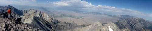
With COR behind me -- holysh*t, now it's behind me and waiting for my return! -- I followed the last 800-1000' to the summit. This section is physically challenging, with steep, loose scree sometimes requiring four paws on the trail. But no exposure in this clip, and I was well-prepared for the physical challenge. Shortly after crossing into the sunlight, I scampered to the peak of Mount Borah, to enjoy the moment with 7 or 8 others who summitted before me. After some fuel, some pictures, and signing the summit log book, I started back down. COR was messing with me again, and I wanted to get it over with.
Back at the snow-bridge, I ran into a guy named Gary, who had started up COR after me earlier in the morning. He had impressively climbed across COR with a SLR camera & big-ass lens dangling from his neck! I told him I was thinking about doing the "go around" route, because I didn't really savor another dance with the COR. We stood at the snow-bridge for maybe 10 minutes watching 3 climbers struggle mightily in the soft "trail" across a major incline in the "go around" route. Gary said the COR seemed less dangerous to him. While I considered my least-worst option, it began to rain. Well, hail actually. A wet hail, that started to dampen the rocks. Before I knew it, Gary was climbing up the "down-climb" to COR. He wasn't waiting around for more rain, and I wasn't going to be guideless. So I followed as quickly as I could.
When I got to the rock-face of the "down-climb", a father and his two boys (aged 12 and 14, as it turns out) were coming down. The 14-year-old was crab-walking down the middle section to a point that ends in a bit of an overhang. (Remember sidestep to the right at that point, assuming you're sane and facing the rock.) I said to him that it would be easier if he were facing the rock. He looked at me for a second, and then he jumped. From about 8-10 feet up the rock wall he JUMPED to the snow bridge! WTF. Maybe that was his plan all along (which would explain why his back was to the rock) or maybe it was his very effective way of letting me know he didn't need my help. Highly impressive either way. Only . . . he tripped when he hit the snow bridge and tumbled towards a one-way trip off the north side. Fortunately, he laid out, stopped his fall, and crawled back to the top of the bridge.
OK. Kid is probably fine. Kid is definitely not afraid. Back to me. Get me out of here. The hail had now stopped, and I quickly started up the "down-climb" to try to catch up with Gary and retrace my route from the climb up. The return on COR felt just as endless and terrifying as the climb up. Let's just get this over with and climb, scramble, crawl, slither, whatever it takes. Finally, I popped my head over the knife-edge top of one last rock and saw my hiking buddy down below.
He struggles with exposure even more than I do, so I wasn't surprised that he didn't try to get across. But I was surprised that he waited for me, and even more surprised when he told me I had been gone three hours. I had lost all sense of time and would have guessed it was more like an hour and a half. My friend told me about others he had met that had chickened out, others that had mountain-goated across, and about the one guy that was almost too painful to watch -- Weeb. This guy had indeed made it to the base of COR, which was impressive and, in his case, death-defying enough. After climbing up to begin COR, Weeb paused for a picture. Looking through his camera, he blindly took a step back. Then another step. One more and the Potato of Death would be gone off the COR. My friend was watching the whole thing, and instinctively screamed at the guy to watch what he was doing. Weeb looked up, smiled, and waved. My friend was so anxioius watching this guy, that he thought he'd need to leave.
Like most, Weeb then packed away his trekking poles. Only his poles did not collapse, and he packed them perpendicular to his body. Then this walking crucifixion proceeded up COR, trying to wedge his way through the narrow gaps in the rock, only to be bounced back by disagreeable poles. After several tries at defeating physics, Weeb decided to stash the poles in the rocks and continue along on his stroll through the rocks. My buddy put on his ipod, turned the other way, and davened in the wind.
After meeting up again with my friend, we took a short lunch break and then flew down the trail, making it from the base of COR to the trailhead in less than an hour, with a full roundtrip time of 7. 5 hours. As we headed towards camp, we passed the mother of the 14-year-old boy. She had stayed at camp with the family dog. I told her the story about her son jumping off the rock (though I deliberately left out the part about him tripping and narrowly avoiding a fast return trip). She said the 14-year-old was recovering from a broken collarbone from a skateboarding accident. I said, yep, that's the kid.
All in all, Mount Borah will be a vastly different experience for different folks. No one could truthfully say it's not at least somewhat physically challenging. But I do believe many -- and not just teenage boys -- would not find the climb particularly mentally challenging. But, if you're like me and don't tolerate exposure very well, then you'll be glad when you can say it is over. Thrilling, rewarding, and downright terrifying.
P.S. When back at home, I checked the news for any fatalities on Borah that day. There were none. I can see Weeb laughing now.
Some last trivial advice: Definitely bring poles (even if non-collapsable). Stash them (and maybe some extra water) before the start of COR. Bring light gloves (I had some running gloves with little rubber dots on them, which were great on the rocks.) Not essential, but you might want bug-spray if you're climbing in bug season. Lots of water. Lace up tightly for the descent to minimize bruised/lost toenails. Still a great hike if you only go up to the start of COR and back.
Here's a few more pictures:
Nicely done and useful. You should attach this to the Mt. Borah page.
Comments
Post a Comment