

-
 25127 Hits
-
 89.01% Score
-
 28 Votes
|
|
Mountain/Rock |
|---|---|
|
|
45.97011°N / 6.86348°E |
|
|
Trad Climbing, Sport Climbing |
|
|
Summer |
|
|
9357 ft / 2852 m |
|
|
Overview
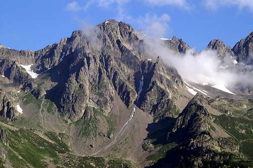
Aiguille de la Glière 2852 m
Aiguille de la Glière 2852 m is one of the major peaks of the Aiguilles Rouges, a fine range of lower mountains (if compared to Mont Blanc group) lying on the North side of the Chamonix Valley, opposite Mont Blanc. This range also includes the Aiguille de la Persévérance, Aiguilles Crochues, and Aiguille de l'Index. The Aiguille de la Glière consists of three summits: North (2,836 m), Central (2,852 m), and South (2,846 m), although these are rarely climbed since the popular routes finish much lower on the mountain. The routes are justifiably popular, since they are all easily reached from the top station of the Index cable car in less than one hour.
Getting There
To reach Chamonix: 1) By bus from Geneva, operated by SAT, several buses daily. See the SAT website for schedule and pricing info. The bus takes a little less than 2 hours and stops also in Les Houches, a smaller village below Chamonix. SAT Bus Company - Tel : + 33 4 50 78 05 33 / Fax : 33 4 50 78 07 62 2) By train via Martigny (Switzerland) when coming from the east or Saint Gervais (France) when coming from the west. Train Tickets Swiss Rail Website
To reach the Aiguille de la Glière: Travel from Chamonix to the smaller village of Les Praz, the departure point for the La Flégère-Index cable car. This can be reached by car (large parking lot) or by bus in 10 min from Chamonix. Take the bus heading to La Tour and get off at La Flégère. The bus runs about every 30 min during the summer and is 1.50 Euro one-way. Take the cable car to the top station (Index) and walk easily to the routes. Chamonix Bus Schedules Cable Car Prices/Schedules
Routes overview
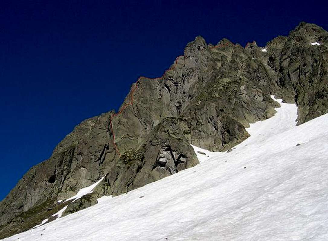
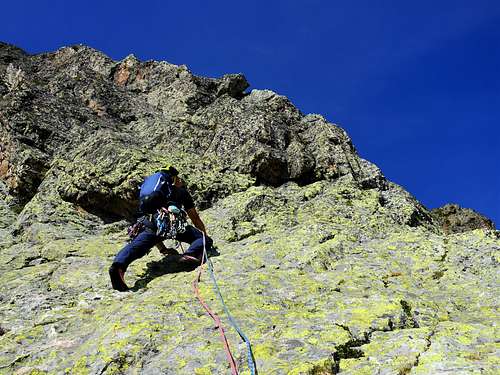
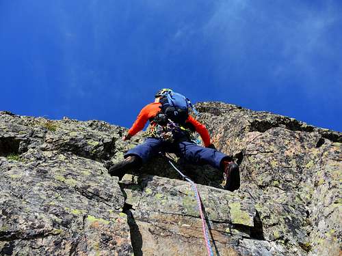
The mountain is best known in reason of the South Ridge route on the Chapelle de la Glière (2,663 m), a prominent tower well below any of the three summits. This route is included in Gaston Rebuffat's "Mont Blanc - The 100 Finest Routes" as Route #4. The route ascends 400m in roughly 14 pitches at a difficulty of UIAA IV+, French 5a, US 5.6-5.7. While several of the pitches are easy (UIAA III or less) and can be passed quickly, the route is fairly sustained and requires 3-5 hours for most parties. The rock is a good gneiss. Since the Aiguille de la Gliere is not too high in altitude, and many of the routes face South, it tends to dry quickly after bad weather and can be climbed when the weather is unsuitable for longer routes on the Mont Blanc side of the valley.
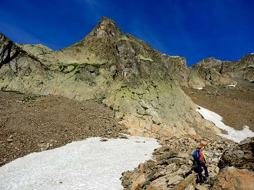
In addition to the South Ridge route on the Chapelle, three popular shorter routes can be found on the SE flank, a structure named Contrefort de la Glière lying just right of the Aiguille de l'Index when facing the mountain (reached in only 10 min from the Index cable car). These routes are very close to each other and similar in character.
- Mani Puliti - French 5b max 5a obligatory, 180 m, 6 pitches, 2-3 hours - First ascent: M. Piola 23 August 1999
- Modern Time - French 5b max, 180 m, 6 pitches, 2-3 hours - First ascent: Rona and Fred Grindley/ Mich Jhonson 2007
- Nez Rouge - French 5b max 5a obligatory, 180 m, 5 pitches, 2-3 hours - First ascent: J. Cellier and M. Meot September 1998
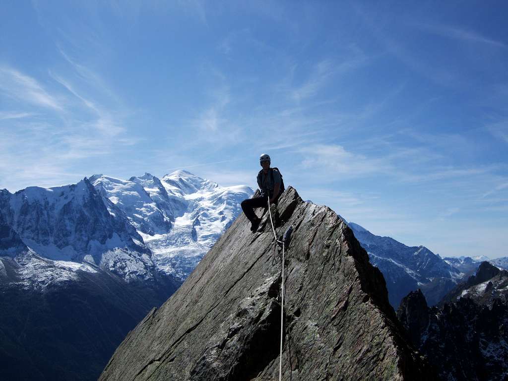
Excellent route descriptions and topos for these routes, and for the South Ridge, can be found in the French guidebook "Les Aiguilles Rouges: Escalade au soleil" by Thomas Dulac and Godefroy Perroux. For those desiring to reach the central summit, it can be climbed by mostly easy scrambling with one pitch of French 4c on the summit tower (a crack on the North ridge). The summit tower can also be climbed more easily by a small crack on the South face, followed by easy scrambling on the east
Red Tape
There are no fees aside from the cost of the cable car (15.50 Euro round-trip to the Index station). Note that the cable car is typically open from mid-June to late-September and also during the winter for the skiing season.
When To Climb
Summer is the preferred season for climbing the Glière. The cable car runs from mid-June to late-September and ascents are typically made during this time. A winter ascent is certainly possible, but not often done.
Where to stay
Chamonix is a primary destination, offering various kinds of accommodation (hotels, huts, gites, renting rooms). There are many campsites in the town of Chamonix (both in the Northern and Southern ends of the town) and in the villages of Les Praz, Argentiere, and Les Houches. They are often very crowded during the high season. Camping is allowed in the mountains, near the Index station for example, but technically only permitted from dusk to dawn. Some people camp here for a few days in order to climb several routes in the Aiguilles Rouges.
Main campsites:
- Camping la Mer de Glace, Les Praz (3 km. North to Chamonix) +33(0)450534403
- Camping les Deux Glaciers, Les Bossons (3 km. South to Chamonix) +33(0)450531584
- Camping les Arolles, close to the centre of Chamonix - +33(0)450531430
- Camping les Cimes, Les Bossons (3 km. South to Chamonix) +33(0)450535893
- Camping les Marmottes, +33(0)450536124
- Camping Glacier d'Argentière, Argentière (8 km. North to Chamonix) +33(0)450541736
Mountain Conditions
The best source for current weather and route information in Chamonix is the Office de Haute Montagne. They can be reached by telephone or e-mail and conditions are often posted on the website. Office de Haute Montagne Tél. + 33 (0) 4 50 53 22 08 / Fax +33 (0) 4 50 53 27 74
Meteo
Guidebooks and maps
There are two main book stores in Chamonix that stock loads of climbing-related literature, including guide books and maps.
- - Les Aiguilles Rouges 1 (Michel Piola). New in 2008, Volume 2 to follow. French only, but supposedly very useful even if you don't understand the text parts.
- - Les Aiguilles Rouges (Thomas Dulac, Godefroy Perroux) (French only)
- - Mont Blanc & the Aiguilles Rouges selected climbs guidebook
Other literature
- - The Mont Blanc Massif The 100 Finest Routes (Gaston Rébuffat) (several editions)
- - Crag Climbs in Chamonix (François Burnier, Dominique Potard). Available in English (ISBN 2910672131) and French.
- - Mont Blanc Massif Selected Climbs (Lindsay Griffin) (Volumes I and II, ISBN 0900523573 and 0900523581)
- - Mont Blanc and the Aiguilles Rouges A Guide for Skiers (Anselme Baud) (ISBN 1904207278)