
-
 7589 Hits
-
 84.82% Score
-
 19 Votes
|
|
Mountain/Rock |
|---|---|
|
|
45.97412°N / 6.87310°E |
|
|
Haute Savoie |
|
|
Trad Climbing, Sport Climbing |
|
|
Summer |
|
|
8366 ft / 2550 m |
|
|
Overview
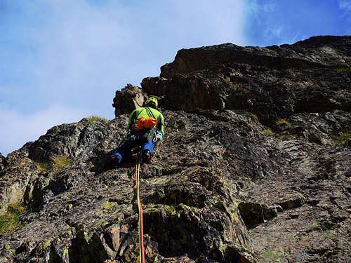
Aiguillette de la Floria
The Aiguilles Rouges Group, in addition to the beauty of the rock and the charm of its spiers and walls, offers an exceptional panorama toward the Northern side of the Mont Blanc massif, considered as one of the most spectacular views of the whole group. This fact contributes to add more interest to the climb in the Aiguille Rouge massif. The gneiss of the Aiguilles Rouges is less rough than the famous Mont Blanc red granite, but it’s rich of sharp holds: the climbing style is very pleasant and technical.

Aiguillette de la Floria is a small but well-identified summit at the foot of the Grande Floria, situated about 15 minutes by walking from the Index chairlift upper Station, along the Col des Crochues trail. On the South wall of this fine triangle of gneiss there are some interesting routes, among which the very classic Arête Rouge, incorrectly called in some guide-books and websites as "Eperon Sublime", which runs along the edge delimiting the wall on the left. The short approach and the situation make it possible to climb when the weather on the Mont Blanc massif is uncertain.

Getting There
The starting point is Chamonix-Mont Blanc m 1087
Main road approachs
- From Valle d'Aosta (Italy): Follow the E25 Motorway towards Courmayeur, then the Mont Blanc Tunnel to Chamonix (65 km. from Aosta)
- From Martigny (Switzerland): Follow the road leading to the Switzerland – France border, then reach the village of Argentiere and Chamonix (45 km. from Martigny, 13 km. from the border)
- From Geneve (Switzerland): Follow the E25 Motorway to St. Gervais les Bains, then the RN 205 to Chamonix
Approach to the walk starting point
From Chamonix Mont-Blanc head towards NE and reach the village of Les Praz (3 km. from Chamonix). Take the cable-car to “La Flegere”, then the Index chair-lift.

From the Index chair-lift station follow downhill towards right (North) the track to Col des Crochues (some snow until late summer) heading to the left spur of the Aiguillette de la Floria and then skirting its S face. The views over the Aiguilles de Chamonix and Mont Blanc are breathtaking! 15 minutes from the Index station.
Arête Rouge report
Arête Rouge report (French scale)
Summit altitude: 2550 m
Difficulty: 5b+ max
Equipment: equipped belays, some bolts and pegs along the pitches
Climbing length: 150 m
Exposure: South
First ascent: Paul Giroud - Thierry Mercier June 25th, 1974
Starting point: Index upper station
Short but aesthetic and pleasant route on the fine pilier on the left edge of the spire. The climb is airy and varied on good quality gneiss. The protections in place may be integrate with cams.

Walking approach From the upper station of the Index chair-lift, take towards North the almost flat path towards the Col des Crochues which after a small lake starts to skirt the South wall of the Aiguillette de la Floria. Once you reach the left ridge of the tower, where it runs the Arete Rouge, leave the main path and climb up a steep slope of stones getting in a few minutes the base of the ridge. Starting point under a vertical wall (stretched string in a hole).
L1 - Climb two short walls in succession, a spur and a slab to the belay, long pitch. 4c, 45m
L2 - Climb a wall slanting left to a small shelf near the edge, under a short overhanging wall with big but flat holds. Overcome it to the right to a comfortable belay. 5b+, 30 m
L3 - Short pitch on a slab, 3c, 20 m

L4 - Steep slab, then a dihedral-crack and belay on the pilier's wire, 4c, 30 m
L5 - Airy pitch. Climb a wall to the left of the pillar wire, then an overhang to a comfortable stop over the summit ridge, 5b, 25 m
L6 - Follow the easy crest, 3c, then easy terrain, 50 m, belay near the exit of a chimney- crack

L7 - Downclimb the chimney-crack to get the base of a slab cut by a thin crack, 3c, 10 m.
L8 - Climb the slab (Dalle à Oin-oin), getting the summit of the spier, 5b+, 15 m
Alternatively to get the summit of the spier: from the sixth belay, instead of downclimb the chimney, you can cross the terrace with debris and scramble up some easy rock to the summit cairn, 2b, 45 m
Descent - From the summit cairn downclimb to get the terrace again, traverse the terrace leftward facing out (to the East) for a few tenths of meters to reach an abseil-anchor. After a 30 meters abseil, descent on debris and boulders to the right and reach a track that skirts the South wall of the "aiguillette". This brief track joins the main path just some meters below the start of the climb.
Other routes
On the S face - starting from the Arête Rouge to the right - we find:

- Les dalles brunes
- La plage report (Camp to Camp) - 5b/5b obbl, 120m L1 4c 30m, L2 5b 30m, L3 5b 30m, L4 5a 30m
- Robin Wood report (Camp to Camp) - 6a (5c and A0), 120m L1 5b 40m, L2 5b 30m, L3 5c 30m, L4 6a 40m
- La lampe d'Allardin report (Camp to Camp) - 6a (5c and A0), 120m L1 5a, L2 5b, L3 6a+, L4 6a, L5 5a
- Athina report (Camp to Camp) 5b, 120m L1 4c, L2 5b, L3 5b, L4 5a
Red Tape
No restrictions in climbing and hiking, no permits, no fees
When to climb

Best season goes from the end of June to the end of September.
Where to stay

Chamonix is a primary destination, offering various kind of accomodation (hotels, huts, gites, renting rooms). Numberless campsites are situated both in the Northern and Southern ends of the town and in the villages of Les Praz, Les Bossons and Argentière. Main campsites:
- Camping la Mer de Glace - Les Praz (3 km. North to Chamonix) +33(0)450534403
- Camping les Deux Glaciers - Les Bossons (3 km. South to Chamonix) +33(0)450531584
- Camping les Arolles - close to the centre of Chamonix - +33(0)450531430
- Camping les Cimes - Les Bossons (3 km. South to Chamonix) +33(0)450535893
- Camping les Marmottes - +33(0)450536124
- Camping Glacier d'Argentière - Argentière (8 km. North to Chamonix) +33(0)450541736
Meteo
Guidebooks and maps
Guidebooks

“Les Aiguilles Rouges – Face au Mont Blanc” by Michel Piola – This guidebook is in English text throughout.
“Alpes Francaises du Nord” by Hervè Galley
"Mont Blanc & the Aiguilles Rouges" selected climbs guidebook
Map IGN 3630 OT Chamonix 1:25.000
Other info
- Office du Tourism de Chamonix - Phone +33 0450 530024
- Office de la Haute Montagne de Chamonix - Phone +33 0450 532208
- Flegere-Index cable car info - Phone +33 0450 532275