
-
 37452 Hits
-
 88.19% Score
-
 26 Votes
|
|
Area/Range |
|---|---|
|
|
44.97400°N / 113.444°W |
|
|
Hiking, Mountaineering, Bouldering, Scrambling |
|
|
Summer, Fall |
|
|
7373 ft / 2247 m |
|
|
OVERVIEW
The Beaverhead Mountains straddle the Idaho/Montana border from Chief Joseph Pass (7264') in the north to Monida Pass (6907') in its southern and eastern reaches. It is widely accepted that the Beaverheads are a part of the larger Bitterroot Mountain range and most maps show this.The Continental Divide does run the length of the range. Lemhi Pass of Lewis & Clark fame is the unofficial boundary dividing peaks in the north from peaks in the south.
The Idaho side has drier terrain, fewer mountain lakes, and generally lower starting points from the valleys. The Montana side in contrast has an abundance of mountain lakes. With the Big Hole Valley being over 6000', the starting points are generally higher for backcountry travel. The winters are longer and there are only about 30 frost free days a year in the West Big Hole.
The Beaverhead summits are on the thin side when it comes to attracting attention. The Beaverheads don't have any of Idaho's 12,000' peaks and they lack the allure of Glacier National Park. Missoula area residents flock to the easily reached and popular Bitterroots. These factors combined with a light population are likely to make your excursion into the Beaverheads a solitary one, which in the end, may not be a bad thing.
HISTORY
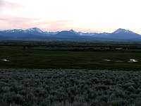 Beaverheads at sunset
Lemhi Pass and Bannock Pass were well established trade and travel routes for Native Americans for many generations prior to the Corps of Discovery and their crossing in 1805. Lemhi Pass was used to access the Montana plains where buffalo could be hunted.
Trappers soon followed Lewis & Clark into the Beaverheads and miners were not far behind. In the early 1900's surveyors made their way through the Beaverhead crest marking the Idaho/Montana state border.
Today you will find small towns dotting the valleys surrounding the Beaverheads with ranching and farming still a common way of life. Local outfitters offer big game hunting, fishing, horse back riding, and white water rafting. Idaho Falls, although a little off the southern end, is the largest city on the Idaho side with Dillon holding that distinction on the Montana side.
So who were the first to stand foot on the Beaverhead summits? Certainly the surveyors summitted most of them. It is not much of a stretch though to surmise that young Native American warriors on a personal quest for strong medicine or to make a name for themselves among their peers were the first to climb these peaks.
GUARDIANS OF THE RANGE
Homer Youngs Peak in Montana is the highest named summit in the northern peaks, while Scott Peak in Idaho takes that honor in the southern peaks. Eighteenmile Peak is the highest peak that sits on the Continental Divide.
HOMER YOUNGS PEAK
10621'

SCOTT PEAK
11393'

EIGHTEENMILE PEAK
11141'
ACCESS
MONTANAMontana access is via I-15, MT 43, and Hwy 278. The road system into the peaks is actually quite good. As always though, the further in that you drive, the rougher the roads become. Twin Lakes, Miner Lakes, Skinner Meadows, and Sheep Creek roads will take you to the jumping off point for access to many of the peaks. These roads do cross private property in places, but there are no restrictions. Roads maintained by the Forest Service are closed until May 15 except for snowmobiles.
IDAHO
The Idaho side is a different story. Main access is US 93, ID 22, and Hwy 28. Fourth of July Creek and Carmen Creek roads provide northern access with no obstacles. South of Salmon though, many roads such as Geertson Creek, Kirtley Creek, Pratt Creek, and Sandy Creek cross private land and can be gated with land owners who may be unwilling to grant access. On the southern end of the range Warm Springs, Myers Creek, and Nicholia are a few of the roads used for access.
Regarding the access issue, the trend has been for new owners to come in and buy ranches, then restrict access to public BLM land further up the drainages. The BLM often encounters a tough time negotiating easement rights with these new ranch owners for public access. Long time ranch owners may be more open to granting access than the new generation of property owners.
The BLM controls 92% of the land, while private ownership is 8%. However, that 8% is concentrated in many of the drainages which of course provide the best access to the mountains.
Some of my personal experience with landowners is that rude and over zealous hunters have caused landowners to close off access to everyone. Instead of evaluating each individual on their specific interest, they have thrown the blanket of no access over everyone.
One story related to me was of a hunting party who had harvested an elk on BLM land and then proceeded to seek out a nearby landowner not only to cross their land, but to provide a vehicle and assist in removing the elk across their property.
What do you do? Contact the BLM for current information, do your research, and respect private property owners. Making yourself odious to a private land owner hurts every climber that comes after you.
MOUNTAIN GALLERY
 Ajax Peak
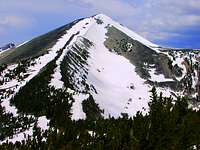 Center Mountain
 Cottonwood Mountain
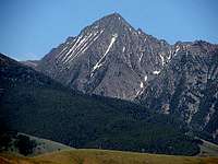 Freeman Peak
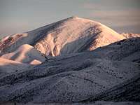 Garfield Mountain
 Heart Mountain
 Hirschy Mountain
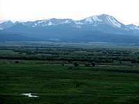 Homer Youngs Peak
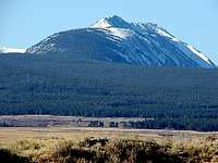 Jumbo Mountain
 Sacajawea Peaks
BEAVERHEAD 10000' CLUB
This is a list of the legitimate 10000' summits in the Beaverheads.Status is based on a rule of 300'. The total stands at 50 peaks.
Webber Peak does fail the test, but is included because it is a named summit on every map and those who tag Webber all count it on their summit list. Most important, it rounds out the list at 50 even.
Peaks with an * are unofficial names. Some are named after people, some because they resemble a structure or shape, and some bear the name of a nearby geographic feature for easier indentification.
If there are any corrections or omissions please shoot me a PM.
North of Lemhi Pass (14)
| RANK | SUMMIT | ELEVATION | LOCATION |
|---|---|---|---|
| 1 | Homer Youngs Peak | 10621' | MT |
| 2 | Hirschy Mountain | 10404' | MT |
| 3 | Sacajawea Peaks | 10390' | CD |
| 4 | Sacajawea Peaks So. summit | 10365' | CD |
| 5 | Center Mountain | 10362' | CD |
| 6 | Monument Peak | 10323' | CD |
| 7 | Freeman Peak | 10273' | ID |
| 8 | Miner Lake Peak * | 10124' | MT |
| 9 | Peak 10080 | 10080' | MT |
| 10 | Berry Creek Peak * | 10060' | MT |
| 11 | Copperhead Peak | 10060' | ID |
| 12 | Skytop Peak * | 10056' | CD |
| 13 | Don Moore Peak * | 10042' | CD |
| 14 | Ajax Peak | 10028' | CD |


South of Lemhi Pass (36)
| RANK | SUMMIT | ELEVATION | LOCATION |
|---|---|---|---|
| 1 | Scott Peak | 11393' | ID |
| 2 | Huhs Horn * | 11292' | ID |
| 3 | Webber Peak | 11284' | ID |
| 4 | Eighteenmile Peak | 11141' | CD |
| 5 | Cottonwood Mountain | 11024' | CD |
| 6 | Italian Peak | 10998' | CD |
| 7 | Garfield Mountain | 10961' | MT |
| 8 | Jump Peak | 10941' | ID |
| 9 | Acropolis Peak * | 10821' | CD |
| 10 | Tuscany Peak * | 10776' | CD |
| 11 | Baldy Mountain | 10773' | CD |
| 12 | Lima Peak | 10706' | MT |
| 13 | Mount Carpenter | 10684' | CD |
| 14 | Sunny South * | 10601' | MT |
| 15 | Cul-de-Sac * | 10529' | MT |
| 16 | Lima Peak 10441 | 10441' | MT |
| 17 | Heart Mountain | 10422' | ID |
| 18 | Dianes Peak * | 10404' | ID |
| 19 | Lima Peak 10388 | 10388' | MT |
| 20 | Peak 10340 | 10340' | CD |
| 21 | Simpson Creek Peak * | 10320' | CD |
| 22 | Copper Mountain | 10303' | ID |
| 23 | Red Conglomerate Peak | 10250' | ID |
| 24 | Maiden Peak | 10227' | MT |
| 25 | Tendolia Peak * | 10201' | MT |
| 26 | Edelman Peak * | 10201' | ID |
| 27 | Horse Prairie Peak | 10194' | CD |
| 28 | Elk Mountain | 10153' | CD |
| 29 | Clear Creek Peak * | 10126' | CD |
| 30 | Conical Top Peak * | 10125' | ID |
| 31 | Dead Horse Summit * | 10120' | ID |
| 32 | Reentrant Peak * | 10100' | CD |
| 33 | Peak 10077 | 10077' | CD |
| 34 | Bull Peak * | 10067' | ID |
| 35 | Dad Creek Peak * | 10025' | MT |
| 36 | Indian Head Peak * | 10001' | ID |


LAKES
Like most mountain ranges the Beaverheads contain an abundance of alpine lakes. Although the Idaho side is noticeably thin, Montana makes up for it with countless lakes and tarns.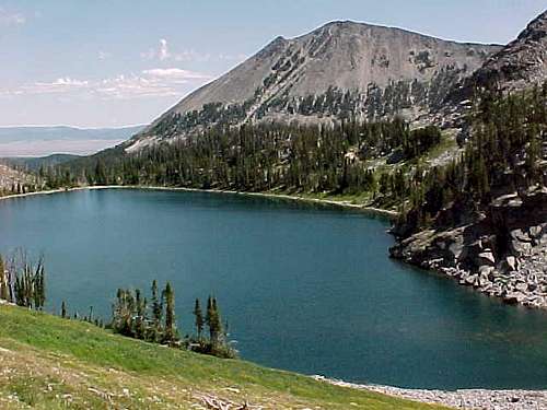 Ajax Lake
Twin Lakes (75 acres) and Lower Miner Lakes (54 acres) are the two largest Montana lakes. Both have USFS campgrounds and are popular fishing destinations. Rainbow, cutthroat, eastern brook, golden, and lake are some of the trout species that can be fished in many of the Montana lakes.
Skytop Lake at 9350' is the highest lake with a name attached to it on the Montana side of the divide while Lake 9573 just north of Scott Peak is the highest Idaho lake.


The Beaverhead-Deerlodge National Forest lake and fish directory can be found here.
CONTINENTAL DIVIDE TRAIL
A work in progress aptly describes this trail. Stetching from Canada to Mexico it continues to be in development since first mandated by Congress in the late 1970's. Specific to the Beaverheads, it is well developed and easy to follow in some stretches. Other stretches are undeveloped and difficult to follow. In some sections the travel is reduced to simply following blazes from one tree to another through forested and general terrain. Sections north of Lemhi Pass fit this description.Long stretches of trail drop into Montana as travel on the divide itself is negated by rough terrain. Solo adventurers and small parties do travel the CDT with little fanfare and only the rewards of their own experience.
Solid planning and sound navigation skills are keys to travelling the CDT through the Beaverheads.
Additional information on the CDT can be found from these two organizations:
The Continental Divide Trail Alliance is a group committed to seeing the CDT fully completed and appropriately maintained for users present and future.
The purpose of the Continental Divide Trail Society as stated in their mission statement is "to help in the planning, development, and maintenance of the CDT as a silent trail and to assist users to plan and enjoy their experiences along the route".
GUIDEBOOKS
 |
 |
 |
___
Wild Montana by Bill Cunningham has good general information on the West Big Hole and specific on Homer Youngs Peak.
___
Climbers Guide To Montana by Pat Caffrey contains information on routes from the Montana side. Some route descriptions are just a few words, while others are very detailed.
Since Caffrey's book is almost impossible to find and long out of print, feel free to send me a PM on any peak and I will reply with the information that Caffrey has.
___
Idaho A Climbing Guide by Tom Lopez is an excellent source for climbing in the Beaverheads and certainly the definitive work for any climbing in Idaho.
SUMMARY
The Beaverheads are in remote and lightly populated country. Thus they are uncrowded and offer a rewarding high country experience to those who want to seek it out. Certainly one of the West's hidden gems. Have a good one! Peak 10080
AREA ADMINISTRATORS
BLM Idaho:Salmon Field Office
1206 S. Challis St.
Salmon, Idaho 83467
208-756-5400
Salmon-Challis National Forest
Forest Supervisor's Office
50 Hwy 93 South
Salmon, Idaho 83467
208-756-5100
North Fork Ranger District
11 Casey Rd.
PO Box 180 Hwy 93 North
North Fork, Idaho 83466
208-865-2700
Caribou-Targhee National Forest
Supervisor's Office
1405 Hollipark Drive
Idaho Falls, Idaho 83401
208-524-7500
Leadore Ranger District
176 N. Railroad St.
PO Box 180 Hwy 28
Leadore, Idaho 83464
208-768-2500
Dubois Ranger District
127 West Main
PO Box 46
Dubois, Idaho 83423
208-374-5422
Beaverhead-Deerlodge National Forest
420 Barrett St.
Dillon, Montana 59725
406-683-3900
Wisdom Ranger District
PO Box 238
Wisdom, Montana 59761
406-689-3243