
-
 12232 Hits
-
 89.77% Score
-
 30 Votes
|
|
Mountain/Rock |
|---|---|
|
|
45.23000°N / 113.648°W |
|
|
Lemhi/Beaverhead |
|
|
Hiking, Bouldering, Scrambling |
|
|
Summer, Fall |
|
|
10362 ft / 3158 m |
|
|
Overview
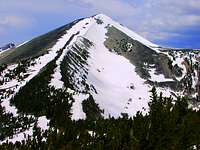
The Beaverhead's Center Mountain (10362') sits along the Continental Divide rising to the east of Salmon, Idaho. A beautiful mountain on its own, it is nevertheless overshadowed by its high profile neighbors on the divide to the northwest - Freeman Peak, Monument Peak, and the Sacajawea Peaks.While those peaks are easily seen from Salmon, Center Mountain with a more southeastern location, is hidden behind the foothills and can't really be seen clearly until you are south of Salmon on Hwy 28. When viewed from Montana though, Center Mountain shows a profile of long graceful ridgelines visible for miles amidst Big Hole countryside.
 Center Mountain
Center Mountain plays host to a number of high mountain lakes. Berry Lake, Hamby Lake, Timberline Lake, and Lake Geneva in Montana along with Idaho's Geertson Lake are a few that inhabit the area.
Center Mountain can be found in Idaho A Climbing Guide by Tom Lopez and Pat Caffrey's 'Climbers Guide to Montana'. Lopez' guide has a sizable amount of descriptive material on both Center Mountain and Skytop Peak and is worth the read.
For those who take on Center Mountain and add Skytop Peak as well, you will be treated to an excellent ridge top hike along some remote Continental Divide country offering great views of both states.
Getting There
Idaho approachFrom the Mormon church in Salmon, travel south on Hwy 28 for 5.3 miles to N. Barracks Ln. Turn onto N. Barracks Ln. (you can see Center Mountain straight ahead from here) and travel 1.2 miles to Bohannon Creek Rd.
Travel up Bohannon Creek Rd. for 2.7 miles to the junction with the W. Fork Wimpey Creek Rd. Straight ahead is the Eagle Valley Ranch where public access is not allowed by the landowner. Turn right onto the W. Fork Wimpey Creek Rd. The BLM has a public access easement up this road.
Travel 4.3 miles on a single track up through the foothills until you come to a junction. Wimpey Creek Rd. continues straight ahead. However, take the left fork at this point. Topozone shows this road clearly in Quad 6 with the 7255' spot elevation marking this left fork.
From here you will eventually run into some 4WD terrain and it will be your choice on how far you want to drive. About 1.3 miles up this road it forks again. Whether you are driving or hiking at this point, take the left fork and go up the hill. The road finally ends at 8000' and there is just enough room to turn around.
Taking the left fork at 7255' will put you in a much better position to take on Center Mountain and Skytop Peak than following the W. Fork Wimpey Creek Rd. up to the divide as indicated in Lopez' book.
5.3 mi - Mormon church to N. Barracks Ln.
1.2 mi - N. Barracks Ln. to Bohannon Creek Rd.
2.7 mi - Bohannon Creek Rd. to W. Fork Wimpey Creek Rd.
4.3 mi - W. Fork Wimpey Creek Rd. to 7255' junction
Montana approach
About 1 mile south of Jackson, Montana take the Skinner Meadows Rd. (381). Follow this road until you reach the Van Houten campgrounds. According to Pat Caffrey in 'Climbers Guide to Montana' your approach will be up the Berry Creek drainage.
There is a 4WD road/trail heading into the Berry Creek drainage, and this is certainly what you want. However, the topo maps are not real clear on how to access it.
There is probably an access road from the area of the Van Houten campgrounds that will take you in. I did not scout on my trip through as there was another objective in mind that day.
The Wisdom Ranger District may be the best source to contact for access information.
Summit Routes
IdahoFrom the end of the road, simply head up and follow the stream that flows out of the drainage that you are in. The crest of the divide is clearly visible and it is your choice at what point you want to gain it, if you choose to.
Once on the divide, Center Mountain will show itself and you can pick your best route along the divide to gain the summit.
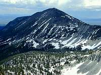
 Center Mountain
If you do gain the summit of Skytop or Peak 10049 first, there is 500' of elevation loss to the final saddle (9520') below Center Mountain.
Class: 2
Round trip distance: 7-10 miles depending on starting point
Round trip elevation gain: 3000' - 4000' depending on route and options
Montana
Caffrey indicates the southeast ridge from the head of the Berry Creek drainage.
 Center Mountain
Options
Skytop Peak (10056)Skytop Peak is located roughly 2 1/4 miles to the southeast of Center Mountain along the divide. Although Skytop is an unofficial name, the name has probably stuck due to it being a high point above Skytop Lake. From Hwy 28, Skytop appears simply as an elevated bump along the Continental Divide ridgeline.
 Skytop Peak
Ironically enough, you can't see Skytop Lake from Skytop Peak unless you traverse about 10 minutes further southeast on the divide to the next high point at about 10000'. To add to your confusion, this unnamed high point at 10000' has two sizable cairns and a surveyors state boundary marker, while Skytop has only a couple of small cairns.
So what about the elevation discrepancy? Lopez' guide lists Skytop at 10056' while Topozone lists Skytop at 10052'. I will entertain answers to this one from anyone who can unravel the mystery.
Center Mountain, Skytop Peak, Peak 10060 Loop
This loop is an obvious choice from a Montana starting point. From the head of Berry Creek head for the summit of Center Mountain. Then follow the divide southeast to Skytop Peak. From here head off to the northeast and climb Peak 10060 making it a three peak loop for the day.
 Peak 10060
Prepare for a full day and a lot of up and down on this one, especially if you add Peak 10049.
The nice thing about this loop is that most of the route is clearly visible from any vantage point during your trek.
Camping
Salmon, Idaho is the closest city and there are many options in and around the area. Salmon ChamberTower Rock recreation area is one of many paved overnight areas up and down the Salmon River. Overnight fee is $5.00.
The 7255' spot elevation in the foothills has several places where you could pull off the road, set up camp, and enjoy the night lights shining up from the Lemhi Valley.
Red Tape
As long as you turn onto the W. Fork Wimpey Creek Rd., the privately owned Eagle Valley Ranch will not be a factor.You will not encounter any restrictions on the Montana side as the state is the access czar.
 Timberline Lake
Area Administrators
BLM IdahoSalmon Field Office
1206 S. Challis St.
Salmon, ID 83467
208-756-5400
Wisdom Ranger District
PO Box 238
Wisdom, MT 59761
406-689-3243