

-
 9607 Hits
-
 71.06% Score
-
 1 Votes
|
|
Trailhead |
|---|---|
|
|
46.37975°N / 114.25173°W |
|
|
Ravalli |
|
|
4100 ft / 1250 m |
Climbers' Access to Sky Pilot & Totem Peak
Drive north from Hamilton, MT for eight miles and turn left (west) onto Bear Creek Road (known locally as Tucker Crossing).Drive for 2.3 miles and turn right (north) onto Red Crow Road.
Go about three-quarters of a mile and turn left (west) onto Bear Creek Road. Follow the road (part paved, part gravel)to the trailhead.
The trailhead is well marked and contains bathroom facilities.
For information about the climbers' route accessed from this trailhead, see the link included in the picture's description.
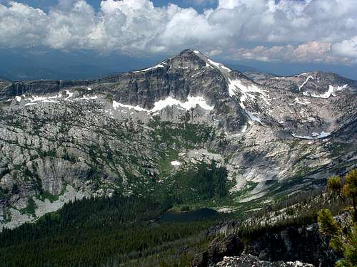 Gash Point affords a great view of Sky Pilot with Bear Lake at its base.
As of yet, there is not an official Summitpost route from this trailhead to Totem Peak, but it should be possible.
Michael Hoyt - Dec 21, 2006 1:33 am - Hasn't voted
Re: totem peak alsoDone!