
-
 13137 Hits
-
 87.76% Score
-
 25 Votes
|
|
Mountain/Rock |
|---|---|
|
|
39.97100°N / 114.6025°W |
|
|
White Pine |
|
|
Hiking |
|
|
Spring, Summer, Fall, Winter |
|
|
10023 ft / 3055 m |
|
|
Overview
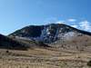
 Wild Horses with Becky Peak.
Becky Peak lays at the most northern end of the Schell Creek Range in White Pine County, Nevada. This seldom climbed peak comes in at number 111 on the Nevada Prominence List. Driving south on Alt HWY 93 from Wendover one can see Becky Peak majestically rise once you pass White Horse Pass to the Southwest. The mountain consists of two summit humps, with the southern one being slightly higher. The 360 degree views from the summit are breath taking. On a clear day one can easily see the Cherry Creek Range to the west, the Schell Creek range including the crest of the Schell Creek Range, Great Basin National Park with Wheeler Peak, and Ibapah Peak to the East in Utah.
With a good high clearance vehicle one can drive up to about 8,950 feet on the Northeast side of the peak. If you don’t have a high clearance vehicle one could park on the west side of the peak, taking a dirt road on the East side of HWY 93. This would require between 2000-4000 feet of elevation gain depending on where you park to reach the summit.
Be aware that Becky Peak is out in the Nevada desert. The closest place to buy gas and food is McGill, NV which is about 40 miles to the south. If you are driving from the North, your last stop would be Wendover, UT/West Wendover, NV. Be sure to have plenty of water and food. You might not get a cell phone signal out here either.
Getting There
 |
 |
 |
 |
These directions are for hiking Becky Peak from the East Northeast. A High Clearance vehicle is highly suggested.
From Ely, NV
Drive North on HWY 93 for approx 39.1 miles
From Here, follow the GPS Coordinates in the table below and reset your Odometer.
| WPT | Directions | Latitude | Longitude | Distance to Drive (mi) |
|---|---|---|---|---|
| WPT 1 | Turn Right onto SR-2 [CR-18] | 39°47'42.9"N | 114°43'57.2"W | 10.8 |
| WPT 2 | Turn Left (North) | 39°49'34.7"N | 114°33'41.0"W | 7.5; 10.8 miles from HWY 93 |
WPT 3 | Turn Left (West) into Box Canyon | 39°56'57.2"N | 114°34'02.3"W | 5.6; 18.3 miles from HWY 93 |
| WPT 4 | Park | 39° 58.4030'N | 114° 35.2646'W | 23.9 miles from HWY 93 |
From Salt Lake City, UT
From Here, follow the GPS Coordinates in the table below and reset your Odometer.
| WPT | Directions | Latitude | Longitude | Distance to Drive (mi) |
|---|---|---|---|---|
| WPT 1 | Turn Left off of Alt HWY 93 | 40° 6.281'N | 114° 114° 33.134'W | 9.0 |
| WPT 2 | Turn Right | 39°59'07.3"N | 114°30'57.1"W | 1.9; 9.0 miles from Alt HWY 93 |
WPT 3 | Turn right at Fork | 39°59'31.4"N | 114°32'53.3"W | 4.5; 10.9 miles from Alt HWY 93 |
| WPT 4 | Park | 39°58'24.2"N | 114°35'15.9"W | 15.4 miles from Alt HWY 93 |
 Cattle Guard you encounter via Salt Lake directions
Routes
|
|
 |
 |
The shortest route is approximately 1 mile (2 miles round trip) with about 1,070 feet of net elevation gain from the East NE. For a more detailed description follow this route.

Red Tape/Camping
None. There are no concessions (i.e., no gas, lodging, food, campgrounds) on the Wildlife Refuge. Camping is permitted anywhere within 100 feet of a designated road as long is it is not within 1/4 mile of a water source. Campfires are permitted using dead wood. Note though, that Becky Peak lies within Becky Peak Wilderness. Cherry Creek Range
When to Climb
Becky Peak can be climbed year round. Climbing during the snow season (November-May) may require a lot more effort.
Summit Shots
 |
 |
 |
External Links
