
|
|
Mountain/Rock |
|---|---|
|
|
39.23230°N / 115.5413°W |
|
|
White Pine |
|
|
Hiking |
|
|
Spring, Summer, Fall |
|
|
10745 ft / 3275 m |
|
|
 Final ridge leading to Mt. Hamilton's summit
 Bristlecone remnant
Overview
 I'm heading up to the summit
 I had wanted to climb this mountain for several years since I had driven both east and west on US 50 many times and had always noticed this mountain located off to the south of the highway as I neared Ely when driving from the west. However, I knew very little about the mountain nor how to access it and when some friends climbed it recently, I borrowed their beta and put it on my to do list. (Thanks to Greg, Kadee and Victor) Ken Jones and I visited the summit just a couple weeks after they did and by doing so, we were the most people to have visited this one in a one year period in the history of the register, particularly in a two week span. Located west of Ely Nevada, Mount Hamilton is fairly accessible thanks to roads that are in pretty decent condition.
W.A. Hamilton was a surveyor who surveyed the townsite of Hamilton in May of 1869 and for him the mountain and town were named.
One of Nevada's top 100 prominence peaks with just over 3000' of prominence making it come in at #65 on the list. Located near a ghost town of Hamilton that was once one of the biggest towns in White Pine county, it is an area full of western history. As you travel highway 50, Mount Hamilton is the obvious large mountain on the south side of the highway. The west side of the mountain is obvious due to the mining that has taken place over the years. The high price of gold has created new interest in mining on this mountain and the west side is now being actively mined. (See this linkand this link)
Getting There
From Ely Nevada, drive west on US 50 towards Eureka. About 45 miles from Ely, just after passing over Little Antelope summit and coming out of the canyon, watch for a sign that directs you toward Belmont Mill. Take a left on this non paved road and head south. At the first fork after turning off the main highway, there is a sign for Belmont Mill again so take the left fork. Continue on this directly south and stay on the most obvious road till you come to the old Mill, a distance of about 9-10 miles from US 50. The road up to this point would be passenger car capable but after reaching the Mill, the road deteriorates and requires high clearance. 4 WD drive would probably not be necessary but it is nice to have in a few places as you head south on the jeep road. You could walk it from the mill if driving a low clearance vehicle.Belmont Mill Waypoint (nad 27) 39.2764 115.5138 Elev 7550
 Find this area and Find this area and |  you are on the you are on the |  right road right road |
Red Tape & maps
For the route described below, there is no red tape that I am aware of. The east side of Mount Hamilton is primarily BLM land.Bureau of Land Management
Ely District Office
702 North Industrial Way
Ely, NV 89301 Phone: 775/289-1800
 From US 50 From US 50 |  Midway to Belmont Mill Midway to Belmont Mill |  From Belmont Mill to TH From Belmont Mill to TH |
Camping
Nearby Ely has several fine motels to choose from as well as supplies and gas. You can also car camp on BLM land where feasible and provided you make your camping experience a leave no trace visit.As far as a developed campground if needed, the nearby Illipah reservoir provides 17 camp sites on a first come first served basis.
Description: Elevation 6,840 ft. Reservoir provides boating, fishing. Illipah Reservoir is stocked with rainbow trout.
Location: 37 miles west of Ely on US 50. Turn at the highway sign for Illipah Reservoir and continue 0.1 mile to a road junction, turn left and continue 1.3 miles to the campground. If you don't turn left, you will find yourself on the way to the old ghost town of Hamilton, about ten miles up the road.
Weather
Ely Nevada
Click for weather forecast

Click for weather forecast
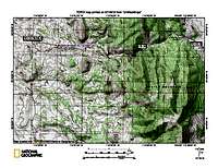
Route and maps
East side:From where we parked,(nad 27 39.2418 115.5255 Elev 8850) it was about two miles and two thousand feet of elevation gain to hike to the summit.
West side:
While we could see roads not far below us on the west side, it is unknown to myself whether those roads provide access or not considering the recent mine activity currently going on. We do know that the east side worked nicely for us and considering that it was only 4 miles roundtrip and barely 2000' of elevation gain with no red tape to deal with, I wouldn't hesitate to do the same route again.
 Wash leads up to 9200'level Wash leads up to 9200'level |  Up the slope Up the slope |  Head for ridgeline Head for ridgeline |
 Looking back Looking back |  Angle of slope Angle of slope |  Top out on No Hamilton & head south Top out on No Hamilton & head south |
 Route to summit
Ken Jones has posted a GPS track from our hike at peakbagger.com Click here to see that information
Summit pics
 Ken on summit Ken on summit | 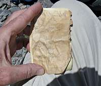 24 year old register 24 year old register |  Central Benchmark Central Benchmark |
 Summit & view south Summit & view south |  View north View north |  View east View east |
Ken and I have hooked up for quite a few 4 day weekends for our trips to Nevada. He flies into the SLC airport and I pick him up on a thursday night and we start driving as far as we can get before the need for sleep hits us. We had a goal set for 4 peaks that were in the central part of the state and they included Mount Hamilton, Table Mountain, Summit Mountain and Cherry Creek Benchmark mountain. All were in the 10,000 foot arena since this was the perfect time of year to avoid snow problems and have somewhat cooler air while we were hiking since Nevada heats up in June.
Mount Hamilton was our first priority and so we were able to find a camping spot an hour from Ely and after gassing up in Ely, we headed west toward the turnoff which would allow us to get to the Belmont Mill. The roads were good until that point and from the Belmont Mill, the road became a jeep track where high clearance was necessary. We found our way to the spot where Greg and Victor had parked and made our way up from there. It was an enjoyable effort and we found the summit and the views in all directions to be outstanding. It was fun looking through the old register and noting that not many others had been up to the top in the quest of peakbagging. The weather started changing and so we relunctantly made our back down to our vehicle and headed for our next target, Table Mountain. Stay tuned for a trip report on that one when I get the time.
History of the area
Scenic tour information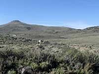 Old townsite
Since Mount Hamilton is located near a historic ghost town, it seems appropriate to include a little information about this area for those who might be interested. Located on the east side of Mount Hamilton, was the boomtown of Hamilton. Also, worth knowing about is the Belmont Mill site, which you will pass through if you go via the route I've provided. Knowing the history always enriches an experience for myself, I hope it does for you as well.
The town of Hamilton boomed in 1868 and 1869 following the discovery of rich silver deposits nearby, but the ore deposits proved shallow and by 1870 the region was already in decline. Hamilton became the first county seat of White Pine County in 1869, but lost that designation to the town of Ely in 1887.
From ghosttowns.com comes the following information:
The beginning of Hamilton in 1868 started a boomtown that resulted in 25,000 people of all types migrating to the area where silver ore was for the taking. Or so it was thought. That it was partially correct lasted until 1887 when big-scale production ceased. All the silver was on top and none below. At 8,000 feet elevation, people weren't about to stay to see if a real vein could be located. People moved out almost at the same rate as they moved in, in 1868. By then there had been shipped a total of $22,000,000 in silver bullion. Hamilton is off of highway 50 between Eureka and Ely. Treasure Hill was the site of discoveries in late 1867. The area was not suitable for a townsite, so one was located at the base of Treasure Hill in May of 1868. The town was given its name after a W. H. Hamilton, one of the three that laid out the townsite. By June, the town had a population of 30 and one business establishment—a saloon. Rich discoveries on Treasure Hill created a boom and a huge rush to Hamilton took place. By winter, Hamilton’s population had swelled to 600. Once the spring thaw was over, the town had a floating population of over 10,000. Stage lines were running to Hamilton on a regular basis by summer. When White Pine County was organized in March of 1869, Hamilton was selected as the county seat. By summer, Hamilton boasted a population of 12,000. There were close to 100 saloons, several breweries, 60 general stores, and many other businesses. The town also had theaters, dance halls, skating rinks, a Miners’ Union Hall, and a fraternal order. During the peak of the White Pine rush, close to 200 mining companies were operating in the area. But once the uncertainty of the mines potential became known, many of them left the district. Hamilton then experienced a depression and many residents left as quickly as they had come. The population shrunk to 3,915. A disastrous fire on June 27, 1873 spread throughout the business district and caused $600,000 in damage. Hamilton’s slide continued and by late 1873 had shrunk to 500. Another fire struck the town on January 5, 1885, destroying the courthouse and much of what remained in the dying town. Hamilton was dealt its worst blow when the county seat was moved to Ely in 1887. The town was revived in the early 1980s when extensive mining operations began on Treasure Hill. The town now has about 75 residents and care has been taken not to disturb the ruins."
Also visit "Overnight in a Ghost town"
Belmont Mill (link)
The following from Richard Moreno's article:
"The mining camp of Belmont Mill in White Pine County (not to be confused with the better-known mining town of Belmont, in Nye County) is often so forgotten that it doesn’t even show up in most ghost town guide books.
Of course, perhaps because of this lack of attention, Belmont Mill has managed to remain one of the better-preserved early 20th century mining camps.
Belmont Mill can trace its roots to the famed White Pine County mining boom of the late 19th and early 20th centuries. In 1915, the Tonopah-Belmont Development Company began developing a mine and mill in the area, which is about seven miles southwest of the mining town of Hamilton (now a ghost town).
Records indicate that despite the considerable investment—Belmont Mill was set up as a company town—the mines proved to be marginal and the camp was abandoned after about a decade of mining.
Perhaps because the mining company owned nearly everything at Belmont Mill, much of it remains fairly intact.
For instance, the main mining mill building is quite impressive, sitting on a hillside overlooking a narrow canyon. The structure is substantial, constructed of thick metal sheets attached to a sturdy wooden frame. It is obvious that the builders intended for this structure to last.
Peeking inside the main building—be careful not to touch anything or go inside because the wooden floors don't appear safe—you can still see the milling equipment and a variety of other mining paraphernalia.
You can also still find large elevated wooden bins filled with rocks on the south side of the mill. Apparently, these carts served as counter-weights to lift the ore containers to the top of the mill, where the precious dirt and rocks were dumped into the mill for processing.
Also intact is an aerial tramway (which resembles the kind of aerial lift you find at a Lake Tahoe ski resort) that runs through the center of the building and stretches a quarter-mile or so up the hillside to several dig sites. The tram's thick support cable, while rusted after decades of neglect, still looks like it could haul a fair bit of ore.
If you walk alongside the tram, up the hill, you can get a great view of the mill and surrounding area. Nearby are several of the area's once-lucrative mines, which included such colorfully named shafts as the Dog Star, Jenny A. and Mary Ellen.
Again, be cautious about exploring the area because mine shafts are dangerous.
To the rear of the mill are rusted ore cart rails, which lead to an area where the processed ore was dumped into cargo containers and transported to a refinery.
Adjacent to the large mill structure are other metal buildings, including the original office, as well as a boarding house (still boasting metal bed frames) and a machine shop, which contains some larger tools and assorted pieces of equipment.
All of the buildings are posted with signs proclaiming they are federal government property and warning visitors not to touch or remove anything under penalty of law.
While a business district never developed at Belmont Mill, a handful of decaying wooden structures sit on a hill above the mill, which appear to have been residences. Below the abandoned row of houses you'll also find several rusted hulks of cars of more recent vintage.
Despite its relatively short life, the mill is a classic example of a turn-of-the-century Nevada mining camp and has undoubtedly survived better than most."
From