
|
|
Mountain/Rock |
|---|---|
|
|
47.59745°N / 24.63242°E |
|
|
Maramures |
|
|
Hiking, Skiing |
|
|
Spring, Summer, Fall, Winter |
|
|
7441 ft / 2268 m |
|
|
Overview
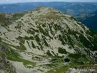
 Vârful Buhăescu Mare -
  Nagy-Bukuly
 Buhăescu peaks (middle) and Pietrosu (right from them) from the east Buhăescu peaks (middle) and Pietrosu (right from them) from the east(image taken on the main ridge trail) |
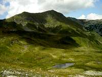
 The Buhăescu Lakes
far view
 The Buhăescu Lakes
near view
Located on the north-south side-ridge that connects the east-west main ridge with Pietrosu /Nagy-Pietrosz/, Buhăescu Mare is the third highest point of Rodnei Mountains /Munţii Rodnei, Radnai-havasok, Rodnaer Gebirge/, after Pietrosu and Ineu /Ünőkő, Kuhhorn/. Its peak is about 1 km away from Pietrosu.
Under its northeast face three small glacial lakes follow each other in a row (there is also a fourth one apart from these). These are the Buhăescu Lakes /Taurile Buhăescului, Bukuly-tavak/. The second one from above has a depth of 5.2m, with this being the deepest in the Rodnei Mountains.
Downstream of the Buhăescu Lakes, the 20 m tall Buhăescu waterfall /Cascada Buhăescu Mare, Nagy-Bukuly-vízesés/ can be found.
General information (applicable also to this mountain) can be found on the Rodnei Mountains parent page. Any additional info (sharing your personal experiences, reporting typos, broken links, etc) is welcome.
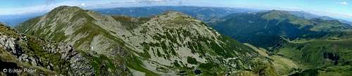
 Buhăescu Mare (a little right from the center) viewn from Pietrosu
Routes
 The beginning
 Viewed from the saddle
Buhăescu is not a difficult mountain to climb (just a little scrambling and walk-up), yet it is worth to do so for the view of Pietrosu and the Buhăescu lakes' valley. There are two possibilities to approach the summit on marked trails:
1) By leaving the main ridge trail at Vf. Rebra on blue stripe northwards.
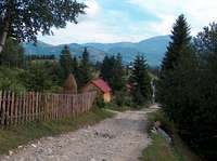
2) Starting from Borşa /Borsa/, following the blue stripe (described in detail below).
A large part of the approach is the same as that of Pietrosul - for details have a look at that page.
After having climbed the steep northeast face of Pietrosul, you will reach the saddle where the path splits into two (both marked by blue stripe). The branch to the west is a short side-trail, leading up to Pietrosul. The one to the south drops down to Curmătura Pietrosului (saddle, Buhăescu Lakes to the east) and continues towards Buhăescu Mare (in front of you).
The marked trail does not lead to the top, instead it goes around the western side of the peak. Leaving the trail on the south side of the peak, it is just an easy walk up (from other directions you have to walk on rockpiles). If you come from Vf. Rebra (main ridge trail), you will be already approaching Buhăescu Mic from the south side. Continuing on the ridge, Buhăescu Mare is just ahead. Once you are up there, and the weather permits, enjoy the closest high-altitude view on Pietrosu!
 Pietrosul viewed from Buhăescu Mare
Getting there
Main ridge trail
This is covered on the own page of the main ridge trail.
Getting to Borşa
By train
At the moment there is no direct train access, but you can get to Vişeu de Jos /Alsóvisó, Unterwishau/ (located on the Beclean /Bethlen/ - Sighetu Marmaţiei /Máramarossziget, Siget/ line) from Cluj-Napoca /Kolozsvár, Klausenburg/ or Braşov /Brassó, Kronstadt/ (and perhaps Satu Mare /Szatmárnémeti, Sathmar/ as well).
From Vişeu de Jos there is a bus that waits behind the train station and goes towards Borşa. Just follow the others who get off the train. It can happen that tourists might be charged a higher fare for the bus than what the real price is (it will not cost much anyway, though). Get off at Borşa center, buy food if you haven't brought enough with you.
For up-to date information about available trains I recommend using the DB website to check actual situation (see External Links section below).
By car
From Cluj-Napoca /Kolozsvár, Klausenburg/ take road 1C to Dej /Dés, Desch/, from there road 17 to Beclean /Bethlen/. Then road 17D to Salva /Szálva/, from there road 17C to Moisei /Majszín/ and finally road 18 to Borşa, which is the next settlement.
From Satu Mare /Szatmárnémeti, Sathmar/ take road 19 to Sighetu Marmaţiei /Máramarossziget, Siget/, from there road 18 leads to Borşa (and on). Optionally you can leave road 19 at Livada /Sárköz/ and take road 1C to Baia Mare /Nagybánya, Frauenbach/ and from there take road 18 to Borşa through Sighetu Marmaţiei.
The easiest way of planning your trip is to use a route planner (one of them is listed in the External Links section below).
By Bus
Bus services are operated to a great extent by numerous small private companies. The best thing is to ask about the possibilities wherever you are at the moment.
Car issues
The remark about parking on the Rodnei Mountains parent page is a bit overcautious. Of course you shall not leave anything "tempting" in the car (better not to leave anything there at all). If you sleep in some pension in Borşa (or in villages nearby), ask the owners of the place about where they recommend parking and where not (probably you'll have the opportunity to leave the car in a closed yard). If you plan or have to park somewhere in public place, leave the car at a busy spot. Foreign licence plate is not uncommon in the area - lot of Romanians who work in Western Europe have cars with Italian, German and other foreign licence plates. But, of course, there is no guarantee ever... (thanks to SP member visentin for sharing his personal experiences with me)
Red Tape
 Ecosystem in work...
Buhăescu Mare and its vicinity are part of Munţii Rodnei National Park (see External Links section), and more specifically, Reservaţia Pietrosul Rodnei. Latter is part of UNESCO world biosphere reserves. There is no entry fee.
Please respect the mountains by taking your garbage back down with you. Also, if you are descending towards Borşa and have an extra bag, you might do some voluntary service by taking trash left behind by others at the refuge on Pietrosu or the meteo station campsite.
When to Climb - Mountain Rescue
 Snow is almost gone
Though both directions are possible around the year, in winter the north side can be dangerous because of avalanches. Perhaps approaching from either the valley of Dragos stream (west from Borşa) or the valley of Repede stream (east from Borşa) offers a safer, yet not much longer journey. These are not marked routes, but the marks would be covered with snow anyway. I have no winter experience here, though.
Phone numbers for Salvamont (Romanian mountain rescue service):
- National Salvamont dispatcher: 0-SALVAMONT (0725826668)
See also the Mountain Conditions and Mountain Rescue sections of Rodnei Mountains parent page.
Camping
 Rebra lake and Buhăescu
 Meteo station campsite
However, camping is only allowed in some designated places in Rodnei Mountains. The following three of them are near to the Pietrosu area, where Rebra is located:
- by Rebra lake (just below Buhăescu, near Tarniţa La Cruce saddle)
- by the Iezer meteo station (under the north face of Pietrosu)
- at Şaua Între Izvoare (saddle, east on the main ridge trail)
There is a small wooden shelter (painted yellow) next to the meteo station (these two are different). The shelter belongs to the National Park administration, and is available only for staff and researchers.
As for the meteo station itself: tourists are generally not welcome inside the territory of the meteo station (fence), although in case of emergency they would let you sleep in the small building.
Weather Conditions
Below you can find a weather forecast for Pietrosul peak (the northern neighbour of Buhăescu) by viewweather.com:
Maps
Paper maps
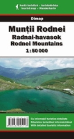
Munţii Rodnei/Radnai-havasok/Rodnei Mountains (1:50,000) by Dimap, with guiding text on the backside in English, Romanian and Hungarian. Can be ordered online directly from Dimap.
Munţii Rodnei/Rodnei Mountains (1:50,000) by Bel Alpin, with guide. Can be ordered online here for £8.00.
Note: The name of this peak was mixed up with another nearby peak (Rebra) on a couple of older maps. Newer editions of these maps show the correct situation.
Online maps
A powerful free online map is being developed by the Open Maps Project for the area of Central Europe. If you are not familiar with the area or want to skip the zooming job, you can get a quick close-up view of Buhăescu's area by following this permalink.
Miscellaneous
General
For further useful travel information about Romania, check out this page
External Links
Panorama from Buhăescu Mare (zooms to Pietrosu peak at 0:50, and to Buhăescu Lakes at 1:10)
Homepage of the Rodnei Mountains National Park (in Romanian only)
Munţii Rodnei page on carpati.org:
only in Romanian, but with good huts ("Cazare") and trails ("Trasee") info, plus an extensive photo gallery ("Fotografii")
Munţii Rodnei page on alpinet.org:
only in Romanian, but has news section ("Ştiri"), topo map (with a list of GPS coordinates - "Puncte GPS asociate") and some huts info
Buhăescu on Peter Budai's Rodnei Mountains website (in Hungarian)
Train search: DB search engine