
-
 9470 Hits
-
 83.01% Score
-
 16 Votes
|
|
Mountain/Rock |
|---|---|
|
|
44.83250°N / 107.7892°W |
|
|
Hiking |
|
|
Spring, Summer, Fall |
|
|
9492 ft / 2893 m |
|
|
Overview
 Burnt Mountain
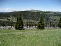
Burnt Mountain is a small peak along the Medicine Wheel Passage in the north Big Horn Range. The mountain consists of a north-south ridge that is about a mile in length and has two summit areas; the grassy knoll that makes up the south summit is about 50 feet higher than the north one, which has some nice rock outcrops just below it. I can not find any information as to how this peak got its name, but there is a sizable stand of burned trees on the west side of the mountain above the east fork of Duncum Creek.
This area is thick with elk and deer, and black bears roam through here as well. During my hike on this peak I was bugled at by a large bull elk, who was about 70 yards below me as I approached the summit. The best time to hike this area is in late June or early July just after the snow has melted; the wildflowers are plentiful and the grass is a very rich and beautiful deep green. Summit views include many of the other gentle mountains in the vicinity, including Bald and Little Bald Mountains, Medicine Mountain, Duncum Mountain, and distant views of the Cloud Peak area.
Getting There and Climbing Information
 Burned trees and Duncum Mountain
 Bald Mountain
From Lovell, Wyoming, take U.S. Highway 14A heading east for about 25.5 miles and turn left on Road 14, which is marked for Devils Canyon. To approach from Sheridan, Wyoming, follow Highway 14 to Burgess Junction, turn right on Highway 14A, and travel for about 18.5 miles. Drive on this road for a little ways and turn right at signs directing you to Burnt Mountain. Follow this road as goes into the trees and turns right onto a rough 4WD road. This road road ends at a gate below Burnt Mountain.
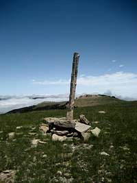 Summit marker
 Grassy slopes below the summit
Hike the abandoned road through the gate onto the western slopes of the peak. This path continues up and over the small saddle between the two summits, where it eventually ties in with a network of abandoned 4WD roads along the Little Bighorn River. Leave the trail at any time to ascend the grassy slopes to the summit, which is marked with a pole and a small cairn.
A round trip hike to the summit of Burnt Mountain and back is about 1.5 miles with 500 feet of elevation gain.
