
-
 4943 Hits
-
 85.36% Score
-
 20 Votes
|
|
Mountain/Rock |
|---|---|
|
|
44.79190°N / 107.9653°W |
|
|
Big Horn |
|
|
Hiking, Scrambling |
|
|
Spring, Summer, Fall, Winter |
|
|
7630 ft / 2326 m |
|
|
Overview
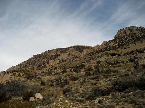
 Summit of Peak 7630
Peak 7630 is an unnamed mountain on the western edge of the Big Horn Mountains near Lovell, Wyoming. The Medicine Wheel Passage (Highway 14A) runs around the base of the peak on its way up and over the Big Horn Range, where it reaches an altitude of around 9000 feet. Peak 7630 is therefore one of the lower summits in this area, as there are a dozen summits up on top that are over 9400 feet.
The prominence of this peak is only about 250 feet due to the fact that it is connected by a ridge to the greater Big Horn mountain mass, but its west face is this mountain's main attraction, offering hikers a fun and very steep scramble up 1200 feet over about 3/4 of a mile. Due to the lower elevation of this mountain, it is accessible well into the winter during times when the other peaks in the Big Horns are covered in deep snow.
 The west side of Peak 7630
Getting There and Climbing Information
From the main road that runs through Lovell, WY, turn onto Highway 14A heading towards Burgess Junction. The best place to park to climb the west face of Peak 7630 is 22.5 miles from the turnoff and is located near the end of the last runaway truck ramp coming off the mountain.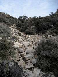 Typical section of the central gully
 Halfway up the west face
Cross the road and pick one of the three gullies that leads up to the ridge. I chose the one in the center because the one on the left, while a more direct route to the summit, is steeper and didn't look as promising. The one on the right lengthens the hike by about 1/4 of a mile and has more trees to navigate near the top. I descended the right one after walking the ridge over to the south summit, which is about 20 or 30 feet lower the highest point. There are faint game trails that can be found at intervals on the mountain, but the majority of the route is off trail on steep dirt, with some sparse brush and scree thrown in at times.
Once you are around the rock spires, you can continue up to the ridge, or cross over into the left gully and head directly across towards the summit. The summit is fairly small and offers great views of the Big Horn Basin, Medicine Mountain and some of the fantastic vertically layered rock formations that make up the western side of this range.
Climbing the west face of Peak 7630 entails a steep Class 2 hike for just under a mile with approximately 1200 feet of elevation gain.
 Summit view showing the vertical rock formations
 East side of Peak 7630
 Five Springs Point
If you are interested in standing on the summit without climbing the steep west face, park at the scenic overlook located another 2.8 miles up the highway. At this point you will be slightly higher than the summit; hike down the steep slope on the trail leading from the parking area and then ascend the gentle grassy slope to the lowest point on the ridge left of the summit. Cross over the ridge and turn right to reach the summit; this route is about a mile in length, but can accomplished pretty quickly because there is only about 300 feet down and up in elevation.
Red Tape
There are no restrictions on climbing or hiking in this area. Deer are abundant on this mountain, and other wildlife often frequent the area. Black bears and mountain lions can be seen anywhere in the Big Horns.Highway 14A is closed to through traffic during the winter and spring months. Recreation and local traffic are allowed according to the sign at the road closure gate, so there was no problem continuing a mile past the sign to park and climb this mountain in late November.
Camping
Places to camp in the Big Horns are numerous, with the majority of the range being open to dispersed camping. Camping is not allowed within 100 feet of lakes or streams, or within 1/4 mile of major roads. For complete rules and regulations, visit: http://www.fs.fed.us/r2/bighorn/recreation/camping/The nearest campground is Bald Mountain Campground, which is located just off the highway on Road 130, which turns south off of 14A. It has fifteen camping spots and typical campground facilities.