
-
 5766 Hits
-
 76.66% Score
-
 7 Votes
|
|
Mountain/Rock |
|---|---|
|
|
44.77270°N / 107.7381°W |
|
|
Sheridan |
|
|
Summer, Fall |
|
|
9953 ft / 3034 m |
|
|
Overview
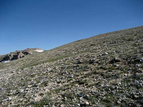 Nearing the summit
The fourth-highest peak in the northern Big Horns in Wyoming is an unnamed mountain that sits just east of Little Bald Mountain and north of Hunt Mountain, which is the highest peak in the area. The headwaters of the North Tongue River are located on its western and southern slopes; this river flows down the eastern side of the Big Horns before heading north into Montana, where it becomes a major river that flows into the Yellowstone River near Miles City. Since Peak 9953 has no official name, I have used the name "Tongue River Peak" for the purposes of this page.
This is a great area to view a large variety of wildflowers during the summer months, and the green and gentle slopes leading to the summit contrast nicely with the white rock formations that are found near the top. This peak is not a strenuous hike, but it is off-trail and requires you to watch your step in some of the rocky areas.
 Rock formations
Getting There
From Lovell, Wyoming, take U.S. Highway 14A heading east for about 31.5 miles and turn left on Forest Road 15. To approach from Sheridan, Wyoming, follow Highway 14 to Burgess Junction, turn right on Highway 14A, and travel for 12.5 miles. Turn north on Road 178, which is a rough two-track dirt road; 4WD is not necessary, but there are spots where it is nice to have it. Park after about 0.7 miles. If the road is in bad shape or looks like it is too much for your car, park just off of the highway and start heading up the slopes right away, which adds just a quarter of a mile to the hike. North Tongue River
After parking at either location, walk east and rock-hop across the North Tongue River, which at this point is near its headwaters and is no more than a small stream. Head up the grassy slopes for about three quarters of a mile, keeping to the right of the rock prominences. There is a large rock cairn that marks the summit, which affords nice views of Little Bald Mountain to the west and Hunt Mountain to the south, as well as distant views of Cloud Peak on a clear day.
 Summit cairn
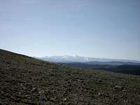 A distant view of Cloud Peak
A hike to the top of Tongue River Peak is a one-way trip of about 0.75-1.0 miles with 600-800 feet of elevation gain.
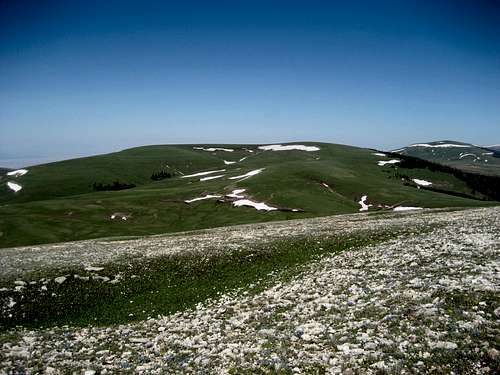 Summit view west to Little Bald Mountain
Red Tape & Camping
There are no restrictions or fees for hiking in this area; keep in mind that the Medicine Wheel Passage is closed from October through mid-May. This area has an abundance of wildlife, so be especially aware of moose, elk, black bears, and mountain lions when hiking in this area. There are no grizzlies in the Big Horns.Places to camp in the Big Horns are numerous, with the majority of the range being open to dispersed camping. Camping is not allowed within 100 feet of lakes or streams, or within 1/4 mile of major roads. For complete rules and regulations, visit: http://www.fs.fed.us/r2/bighorn/recreation/camping/
 Lupine in the Big Horns