
|
|
Mountain/Rock |
|---|---|
|
|
39.87760°N / 115.2698°W |
|
|
White Pine |
|
|
Spring, Summer, Fall |
|
|
9052 ft / 2759 m |
|
|
Overview
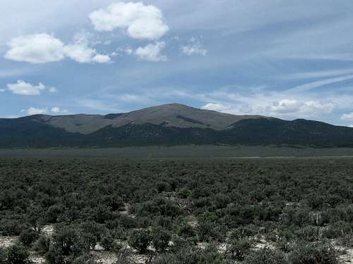
Butte Mountain
This is another truly remote mountain range in Nevada that requires lots of driving on dirt and gravel roads. With a prominence of 2278 feet, this mountain is #130 on the Nevada prominence list. Technically, this is an easy mountain. The hike can easily be done in a few hours by most people but the crux is finding your way to get to this one. It is possible that it might be easier access from the west side of the range but since we did not explore that possibility, I leave that to others to report on. I do know that John Vitz, did the mountain from the west side. This peak is really only one that would appeal to a true Nevada range or prominence peakbagger. There just isn't much to recommend it for otherwise as certainly wild horses would be the main attraction and they seem to roam freely across much of this part of Nevada.
The Butte range is home to several herds of wild horses and their presence can be seen everywhere in this small range. The trails we followed were crafted by the horses and served us very well. Wild horses also attract ticks and as a result, you have to be watchful as you travel the "horsey" trails. I personally picked off close to 30 of them while hiking this mountain but Ken Jones found the answer by wearing nylon pants, he only had a few bother to go after him. Its either the nylon (they can't gain purchase) or they know he doesn't taste very good. I seemed to be number one on their menu selection. This range is rarely visited by anyone these days as it is well out of the way and off the beaten path. Perhaps a few hunters in the fall but we noticed no evidence of recent tire tracks on any of the roads we traveled in that area. A fire a few years back denuded much of the higher slopes but the lack of water and rain in this area has slowed any kind of regrowth.
We had found ourselves on High Bald the day before so it seemed natural to head further south and see what this one had to offer. It took us a little bit to find the road combination but this page will spare you from that trial and error method that we utilized.
Getting There

Caboose Well

Heading towards the peak
This will take a little work but I'm going to share the way to get there from highway 93, the highway that goes between Wells and Ely. At a turnoff for the small ghost town of Cherry Creek, take the pavement right into that town. It is 8 miles of pavement. Once in Cherry Creek (still has folks living there), look for the main road that heads south towards Egan Canyon. It is a good road (dirt & gravel) and take that through Egan Canyon and head south to a junction with a road that heads up towards Telegraph Peak. It is about 7.5 miles to this point. Stay on the main road for another 0.4 mile and watch for an unsigned turnoff to the right. This is the Black Canyon road and is rougher than the roads you've been on to this point. 4WD isn't necessary but high clearance is. It is roughly 12 miles via Black Canyon to get to the good road that runs north and south. When you hit this road, turn right and go about 2.1+ miles to an unsigned turnoff to the left that leads down to Caboose Well. Overall from highway 93 to Caboose Well, it is about 30 miles. From Caboose Well, take the dirt track that heads across the valley toward Butte Mountain. See the map I've added and from Caboose Well to the "trailhead" (end of road), it is another 8.5 miles. Here's a list of key waypoints for
these key landmarks (lat/long nad 27)
39.8995 114.8852 Cherry Creek
39.8200 114.9448 Telegraph Canyon road (this road is signed)
39.8166 114.9521 Black Canyon road (east entry - not signed)
39.8366 115.1116 Black Canyon road (west entry)
39.8740 115.1031 Caboose Well
39.9011 115.2407 End of road Elev 7125
Caboose Well was actively pumping while we were there. Ken Jones in his peakbagger trip report talks about the road beyond Caboose Well. As Ken mentions " Here the road becomes more obscure and high clearance is needed (and possibly 4WD). Heading west from the well is a two-track across the flats. It doesn't look like much - in fact, we looked at it and went another way on our
way in. We shouldn't have. If you can clear the brush in the center ofthe track at the beginning, it gets better. Follow this across the
valley to the 5-way junction and take the northwest trending fork (just north of the main junction)."
This track leads into the canyon northeast of the peak. High clearance and 4WD are a good idea, and a lack of respect for your truck's paint job. The road/jeep trail continues as shown on the map, and then just stops. We camped here.
I'd also recommend a Benchmark mapbook and good supplemental topographic maps (mine are not meant to be anything more than a guide - you should do some good mapwork before you venture out there)
Note: If you use the Black Canyon road, you pass right by the trailhead for another Nevada prominence peak: Ray BM Peak. No summitpost page but if you look at the pic section to the left, you'll find a map I've created with some hints on getting Ray.

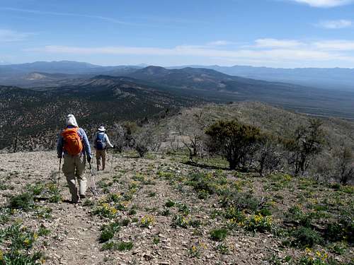
Route

Heading for summit

Dead trees and wild horses
From the end of the road we followed horse trails, mostly, as indicated on the GPS track. Lots of horses in these mountains. No technical
difficulties. See Ken's GPS track for enlightenment. Overall, the elevation gain was about 2000 feet and it was about two and a half miles from where we car camped (our trailhead) to the summit making for a round trip of a bit over 5 miles. I will add a route map in a day or two but Ken's GPS track is really all you need.
Heading down
Red Tape

Looking north from the summit

Looking west from the summit
BLM land. As far as I know, there isn't any red tape in this area of Nevada to be concerned about. The area isn't a wilderness area nor does it have much to recommend it. Stay on the existing dirt roads and don't end up creating new ones as the scars on the landscape could take a century to heal.
Camping and a word of caution
Car camp just about anywhere using the "Leave No Trace" ethics. There are no organized campgrounds in the area and the nearest lodgingwould be found in Ely or Wells / Wendover. Gas is the same situation and in Nevada you will often see signs that tell you that it is over 100 miles to the nearest gas. Carrying an extra supply of gas (see Caution below) might be a good idea. Caution: Because it is far from any services, you would be best served to travel with another vehicle. A breakdown would not be a good situation and your gas tank should be full, have spare tire(s) and you should have plenty of extra water. There is no cell service in this remote part of Nevada and we had none even on the summit. Be sure to let others know where you've gone and when you should be back. You'll need 4WD, high clearance and good mapping skills along with GPS waypoints and any other aid you can provide yourself with. This is really one of the areas I'd be very comfortable having a satellite phone with me.

Looking east from the summit

Looking south from the summit
Summit Register

Register of Butte Mtn
This might be one of the least visited prominence peaks in the whole state of Nevada. A register placed by Gordon MacLeod and Barbara Lilley in 1995 only had a few signees. A geologist from Missoula Montana in 1996, a two man team from Ely checking on the fire aftermath in 2001 and Tom Roundtree in 2004, John Vitz and Donna O in 2006, Greg Jagielski in 2012 and then the three of us (Ken, Dennis and myself). A total of 6 peakbaggers in 18 years. Wow.
Update: Since our visit, Adam Helman, Richard Carey and Bob Packard made a visit in 2014. (Peakbagger.com)

Dirt camp
Weather
Ely is the closest town of any size:
Click for weather forecast

Click for weather forecast
External Links
The prime attraction of the Butte Mountain area is Wild Horses.
Nevada’s Wild Horses and Burros
Welcome to the Silver State…home to nearly half the nation’s wild horses and burros.
These Living Legends move with the seasons within 83 Herd Management Areas on nearly 14.7 million acres of public land managed by the Bureau of Land Management (BLM).
Under the Wild Free-Roaming Horses and Burros Act, BLM is required to manage wild horses and burros only in those areas (Herd Areas) where they were found when the Act passed in 1971. Through land use planning, BLM evaluates each herd area to determine if it has adequate food, water, cover and space to sustain healthy and diverse wild horse and burro populations over the long-term. The areas which meet these criteria are then designated as Herd Management Areas (HMAs).
BLM also evaluates each HMA to determine how much forage is available for use. The available forage is then allocated among wildlife, wild horses and burros and domestic livestock. The number of horses and burros which can graze without causing damage to the range is called the Appropriate Management Level (AML).
Wild horses and burros can quickly overpopulate an area. They have long life spans and are not very susceptible to predation or disease. Left unchecked, wild horse and burro numbers can double in four years. That can severely impact desert rangelands with scattered, small water sources like we have in Nevada.
To bring wild horse and burro numbers in balance with the available food and water, BLM gathers hundreds of excess wild horses and burros from Nevada ranges every year.
Once captured, excess animals are transported to BLM corral facilities where they are vaccinated to prevent illness or disease and given lots to eat and drink. BLM also assigns each animal a unique number – or freeze mark. Once they are ready, they are made available for adoption through BLM’s Adopt-A-Horse or Burro Program. More than 220,000 wild horses and burros have been adopted by private citizens since the program began in 1971. Nearly half of these animals came from Nevada!
From the BLM page:Rangeland and Herd Management (link)
Healthy Horses on Healthy Ranges
The BLM’s goal is to ensure and maintain healthy wild horse populations on healthy public lands. To do this, the BLM works to achieve what is known as the Appropriate Management Level (AML) – the point at which wild horse and burro herd populations are consistent with the land’s capacity to support them. In the context of its multiple-use mission, AML is the level at which wild horses and burros can thrive in balance with other public land uses and resources, including vegetation and wildlife.
This type of rangeland management is different from management of wildlife, which are controlled by hunters and natural predators, or livestock, which are controlled by grazing permits. Because of Federal protection and a lack of natural predators, wild horse and burro herds can double in size about every four years. As of February 2012, the BLM estimated that 37,300 wild horses and burros roamed BLM-managed rangelands in 10 Western states, or nearly 11,000 more than the West-wide AML of 26,500.
In 1971, wild horses and burros were found roaming across 53.8 million acres of Herd Areas, of which 42.4 million acres were under the BLM's jurisdiction. Today the BLM manages wild horses and burros in subsets of these Herd Areas (known as Herd Management Areas) that comprise 31.6 millionacres, of which 26.9 million acres are under BLM management

Wild Horses on Butte Mtn