
-
 9882 Hits
-
 74.92% Score
-
 5 Votes
|
|
Mountain/Rock |
|---|---|
|
|
26.52000°N / 100.35°W |
|
|
7775 ft / 2370 m |
|
|
Overview
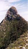
Cabeza de sapo means "the toad`s head", it`s also simply called El Sapo, "the toad". El Sapo is the highest and westernmost peak in the Sierra del Fraile range, located just northwest of the town of Villa de Garcïa in municipio de García, and it`s part of the emblem in it`s flag.
Unlike other peaks in this sierra, el Sapo`s slopes are mostly covered only by thorny brush and agaves dotted with a few "palmito" palm trees in the canyons, so there`s almost no shelter from the sunrays; this plus the fact that the elevation gain is at least 5,000ft (1,524m) including a long traverse on the almost bare ridge, makes climbing this mountain a real challenge in warm weather. Even in cooler weather this mountain is not climbed by many, since it`s a long and streneous hike.
Rising abruptly from the desert floor, el Sapo surpases the other Fraile`s peaks like La Aguja, Pico Everest, Pico Zorros and Pico San Miguel by at least 100m (325ft); the summit has unrestricted views all around; just beyond these peaks one can see all the mountain ranges of northern Nuevo León state, including the Minas Viejas with it`s towering Tía Chena (just to the north); to the west, one can see numerous lower ranges of eastern Coahuila state including the Saltillo area; to the southeast the valley of Monterrey and to the south numerous higer ranges of the Sierra Madre Oriental.
 |  |  |  |
Getting There
From Monterrey take higway 40 towards Saltillo and drive west about 20 miles to the connecting higway leading north (right) to Villa de García, drive about 12 miles to that town and take the left on the "Y" split upon arrival, drive across the town and keep going until the road finally deadends across the cemetery and make a righthand turn, this is the road to Icamole, from here you can see the peak with it`s sheer walls directly in front. Keep driving west 2 to 3 more miles to an area where several small farms can be seen on the right side of the road; the trail starts at the bottom of a big canyon or opening clearly visible from the road. To gain acces you`ll need to leave your car at one of those farms and ask for permission to go through ( don`t leave your car by the highway). The farms by the road lay below 800m, the uppermost one is at 850m. From there, hike to the base of the canyon where the trail zig-zags a little, but once it starts gaining altitude it stays on the right side of the gully. This is the first of two parts of the ascent; the trail is not marked but is easy to follow since the vegetatin is low. Climb up the sometimes very steep slope with some loose sand and scree to gain the mountain ridge, this may take 2 to 3 hours; the second part starts there, it is a long but interesting traverse along the western top ridge and passes three false summits. The ridge is flanked by steep slopes on either side and a vertical drop on the opposite. On two low points between the false summits, the the ridge becomes knife edged and requires careful class four moves. The final stretch is done scrambling on the north side of the summit following a path over a series of narrow ledges and then up a short gully before reaching the elongated summit; this second part takes 2 to 3 hours. One has to be careful when approaching the southern edge of the summit, that cliff drops straight down about three quarters of the way, rivaling the ones at the Potrero Chico area nearby.
 |  |  |  |  |
Red Tape
Even though this is part of the Cumbres de Monterrey National Park, no permits are required, but since the trail starts in private property, you must get permission from the land tennants.
When To Climb
The best time is from November to March when the weather is cool and the storms are at a minimum. This climb is streneous at best and there is no water at all on the mountain; also, there is no shade to cool off, so an early start is beneficial to avoid direct sunrays on the way down.
Climbing this peak in the summer months is discouraged, since the temperatures soar over 100°F (38°C).
 |  |
Camping
The only good spot for camping is high on the ridge between two of the false summits about one hour away from the summit, it`s about 5x6m (15x18ft), and it has breathtaking views to the north and south.
Mountain Conditions
This peak is not climbed by many, so the only ones that can give you an update are the locals, but dry conditions are almost for certain since the area receives little precipitation.
Safety
Make sure you bring plenty of liquids, 5 or 6 Liters at least.
Agaves are everywhere on this mountain, they have razor sharp spikes that can inflict very painful and sometimes life threatening injuries, so it is wise to bring leather gloves and sun/safety glasses for protection and trekking poles to avoid falling on top of one.