
-
 12122 Hits
-
 79.04% Score
-
 10 Votes
|
|
Mountain/Rock |
|---|---|
|
|
28.69861°N / 13.92133°W |
|
|
Hiking |
|
|
Spring, Summer, Fall, Winter |
|
|
912 ft / 278 m |
|
|
Overview
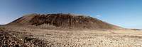
 The crater of Calderon Hondo The crater of Calderon Hondo |
Considering the tourism excesses that present day Fuerteventura has to "offer" it is hard to conceive that the island was a tourist no-man's-land on 60 years ago. Today urbanisations sprout everywhere, leaving the impression that you are visiting a giant laboratory of Aldous Huxley's Brave New World. Some of these new villages are hugely successful, others have been planned with a much grander level than could be achieved and quite a number had to be abandoned. In the north of the island, in the backwaters of the tourist town Corralejo you can find all of the above.
Still, when you look closely, you can find the signs of older times. Some of the old villages are still present and a good example is Lajares, which is famous for its two windmills, watching each other from each side of the main road through the village. From Lajares, an old Camino Real (King's Highway) leads to Corralejo. For once the tourist authorities have set aside their focus on beach and surf and rebuilt part of that Camino Real to create a volcanic lecture trail.
 |  |  |
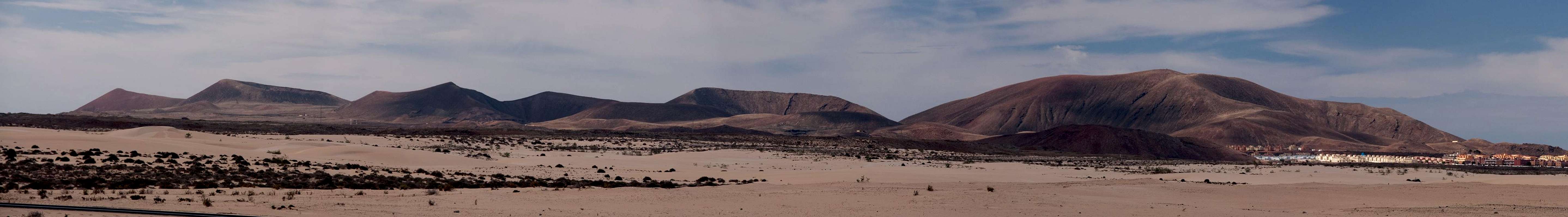
The area between Corralejo and Lajares belongs to the part of the island where the latest volcanic eruptions took place. In two separate rifts volcanoes erupted about 10.000 years ago, covering the north of the island with lava fields and ashes. In fact one of the eruptions, the one by Volcan Bayuyo, extended the size of the island considerably. The volcano emitted lava from two craters, covering the whole north and extending the island by 100 square kilometres. Bayuyo is accompanied by a handful of slightly older volcanoes, which forms a line, stretching from north-east to south-west and ending in two colourful volcanoes, Montaña Colorada and Calderon Hondo.
The name of the latter say it all: Calderon Hondo is a huge cauldron of a volcano with a perfectly circular crater. This crater - like most of the craters on the Canaries is open to the north-east, indicating that weather patterns stayed the same for the last 10.000 years. Still today, north-eastern trade winds prevail on the islands for 75% of the year. In the case of an eruption volcanic cinder gets piled up on the leeward side leaving open the windward side of the crater. In Calderon Hondo's case the elevation differences between upwind and downwind side are not big, resulting in one of the biggest and most beautiful craters of the island.
 |  |  |
The Camino Real passes Calderon Hondo to its south, but a side path leads to the crater rim in its lowest section. To reach the summit you have to either scramble around the crater rim - a dangerous undertaking due to the sharp edged brittle lava - or you traverse from Montaña Colorada across steep and shifting cinder slopes. The western slopes of Calderon Hondo are brightly red while the remainder of the volcano is made up from greyish eroding lava.
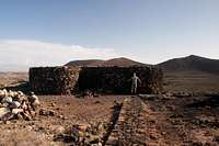
Near Calderon Hindo, to the west of it, an old shepherd's hut has been reconstructed. Goat herding has been one of the major incomes of Fuerteventura (and is still done today, though on a bigger scale) as goats appear to be the only domestic animals to scratch out a living out of the volcanic desert.
Summit Panorama
  |
Getting There
 Calderon Hondo seen from the south-west
Though there are ferries from the Spanish mainland to the Canary Islands, they take more than 24h for the trip. Therefore almost all visitors go by plane. Every travel agency in Europe offers flights, hotel rooms, apartments, rental cars etc. so that reaching the Canaries is rather a matter of money than opportunity. During the summer season flight fares can be reasonable but during the Easter and Christmas holidays you have to be prepared for additional fees of 500€ per person.
Fuerteventura has its own airport south of the capital Puerto del Rosario close to the center of the island. There are public bus lines but – like on all the islands – they don't run too regularly. If you plan to stay on your own, better take a rental car right at the airport.
The shortest ascent to Calderon Hondo starts at Lajares, a village to the north-west of La Oliva, administrative seat in the north of Fuerteventura. It can be reached as follows:
- From the airport near Puerto del Rosario take FV-2 north (direction Corralejo)
- Use FV-3, the ring road around the capital Puerto del Rosario.
- North of the capital the ring road joins FV-1 to Corralejo.
- At Casas de las Llanadas switch to FV-102 to La Oliva.
- In La Oliva switch to FV-10 to Lajares.
- Park at the local sports field (you'll have to hike out along a side road to Montaña Colorada, where the Camino Real starts.
Red Tape
 |
There's no Red Tape here. The Malpais de Bayuyo, one of Fuerteventura's youngest and largest lava fields should be explored by the paved cobblestone paths only. The lava is brittle and easily breaks apart when you step on it, resulting in a severe danger of injuries. Moreover, orientation in the lava fields can be difficult.
Accommodation
For holiday homes, hotels or apartments either consult your nearest travel office, or – search for lodgings on Google. There are several sites on the web, dedicated to rent privately owned houses or apartments. Prices are generally a bit less expensive than for tour operators but you don't have as much security.Corralejo is the nearest tourist centre and there are several "urbanisations" on the road between Villaverde and Corralejo. In Villaverde and La Oliva quite a number of central and north European expatriates have built their summer homes which often are for rent privately.
Weather Conditions
Fuerteventura is usually swept by fierce north-western trade winds. Though they deposit their humidity on almost all of the other Canary Islands, Fuerteventura (as well as Lanzarote is simply too low to form a decent obstacle. Therefore the climate is very arid. However, winds regularly are pretty strong, especially on the mountaintops. It pays to take warm wind-stopping clothes with you.For some time of the year, eastern winds prevail, which almost always carry clouds of Sahara dust with them. Usually this means reduced visibility but in some occasions "Kalima" occurs. Fierce storms take up the dust from the Sahara and sweep it across the islands. In these times visibility is nil and sometimes even airplanes have to be grounded.
Maps & Books
Maps
Regular Maps
- Fuerteventura
Kompass Map WK240
Kompass Verlag
1:50000
ISBN: 978-3-85491-174-6
Digital Maps
Kompass is the only company known to me which offers GPS digital Maps. In addition for those of you with Garmin GPS receivers there is a map source map set of all Canary islands out there.
- Fuerteventura
Kompass GPS4240
Kompass Verlag
ISBN: 978-3-85491-222-4
- Islas Canarias
Map Source custom map
By Manfred Pepper
downloadable zip-file
Books
My recommendation is a guidebook by Rother Verlag, available in German. The book is an excellent hiking guide covering all the interesting areas of the island. Since it comes with small maps for each excursion it might even be used without a map to support them.
- Fuerteventura
Rolf Goetz
Rother Verlag
ISBN 978-3-7633-4303-2