
-
 10065 Hits
-
 80.49% Score
-
 12 Votes
|
|
Mountain/Rock |
|---|---|
|
|
28.62017°N / 13.88861°W |
|
|
Hiking |
|
|
Spring, Summer, Fall, Winter |
|
|
1765 ft / 538 m |
|
|
Overview
 Montaña de Escanfraga Montaña de Escanfraga |
Fuerteventura, the second largest of the Canary Islands is known mainly for its beaches and its surf. It is dubbed the desert island as sand prevails everywhere and there are two areas which consist of sand dunes - and little else. Hikers are rare on the island, mostly caused by the perceived lack of geography. Everything appears to be flat and the highest mountain, Pico de la Zarza reaches only 812m. When seen up close, however, you will realize that there are only very few regions with no vertical relief as volcanoes can be found everywhere.
There are two small mountain ranges on Fuerteventura the Jandia Chain in the very south and the Betancuria Massif in the centre, both remnants of giant stratovolconoes which collapsed ages ago, almost levelling the island. Since then volcanism moved elsewhere on the Canaries with only occasional separated eruptions taking place here. The last of these eruptions occurred around 7000 years ago in the north and centre of the island, extending its area by almost a fifth. One one hand there are the typical chains of volcanoes, also known on Lanzarote, where rifts opened in the earth's crust and several craters emitted lava almost simultaneously. On the other there are standalone volcannoes and the highest one, Montaña de Escanfraga, is a good example.
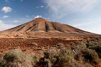 |  |  |
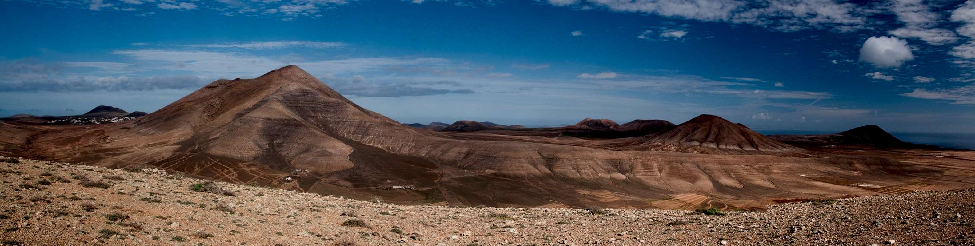
Created during the outbursts of volcanism 7000 years ago, Montaña de Escanfraga posesses a huge crater, open to the north. Thanks to its age its slopes are already very eroded with gullies developed on all sides of the mountain. To the north-east of the volcano some of these gullies combine to form a small canyon, one of the access routes to the summit. The most prominent feature besides the crater is Lomo Delgado, a large spur which runs eastward from the summit and offers the most logical ascent route to the summit. However, the topmost part of this route is very steep with soft, sand-like cinder covering the slopes.
 |  |  |
As the highest mountain in the north of Fuerteventura, Montaña de Escanfraga attracts attention from everywhere. It is a typically cone-shaped volcano placed on a much broader base. During the eruption volcanic activity moved south-eastward, which can be clearly seen from the particular shape of cone and crater. Today, Montaña de Escanfraga lies in one of the driest areas of the island, but thanks to its elevation, the volcano often attracts clouds, which in return moisture on its slopes. In winter it is not uncommon to see bright green patches among the reddish cinder of the mountain.
Getting There
  |
Though there are ferries from the Spanish mainland to the Canary Islands, they take more than 24h for the trip. Therefore almost all visitors go by plane. Every travel agency in Europe offers flights, hotel rooms, apartments, rental cars etc. so that reaching the Canaries is rather a matter of money than opportunity. During the summer season flight fares can be reasonable but during the Easter and Christmas holidays you have to be prepared for additional fees of 500€ per person.
Fuerteventura has its own airport south of the capital Puerto del Rosario close to the center of the island. There are public bus lines but – like on all the islands – they don't run too regularly. If you plan to stay on your own, better take a rental car right at the airport.
The shortest ascent to Montaña de Escanfraga starts at Villaverde, a village to the north of La Oliva, administrative seat in the north of Fuerteventura. However, you have to hike through a quarry pit to reach the caldera rim so that the eastern route across the ridge of Lomo Delgado is far more intteresting. To reach the lomo, you need to pass to the far side of the mountain from Villaverde, which can be most easily done using a dirt road through Valle de Finimoy at the southern base of the volcano.
Villaverde can be reached as follows:
- From the airport near Puerto del Rosario take FV-2 north (direction Corralejo)
- Use FV-3, the ring road around the capital Puerto del Rosario.
- North of the capital the ring road joins FV-1 to Corralejo.
- At Casas de las Llanadas switch to FV-102 to La Oliva.
- In La Oliva switch to FV-101 to Villaverde, where there is a small parking lot behind a bus stop to the right (east) of the road.
Red Tape
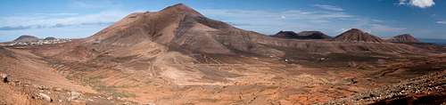
 Montaña de Escanfraga seen from the south-west
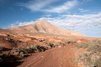
There is no red tape around Montaña de Escanfraga. However, the quarry pit to the west of the mountain and several goat farms around it obstruct some of the best routes to the summit. If you encounter anybody you can be sure to see the blank look of not understanding why anyone would climb a mountain.
Accommodation
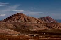
 Fuerteventura's north-eastern volcanoes
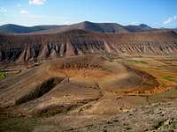
For holiday homes, hotels or apartments either consult your nearest travel office, or – search for lodgings on Google. There are several sites on the web, dedicated to rent privately owned houses or apartments. Prices are generally a bit less expensive than for tour operators but you don't have as much security.
Corralejo is the nearest tourist centre and there are severall "urbanisations" on the road between Villaverde and Corralejo. In Villaverde and La Oliva quite a number of central and north European expatriates have built their summer homes which often are for rent privately.
Weather Conditions
Fuerteventura is usually swept by fierce north-western trade winds. Though they deposit their humidity on almost all of the other Canary Islands, Fuerteventura (as well as Lanzarote is simply too low to form a decent obstacle. Therefore the climate is very arid. However, winds regularly are pretty strong, especially on the mountaintops. It pays to take warm wind-stopping clothes with you.For some time of the year, eastern winds prevail, which almost always carry clouds of Sahara dust with them. Usually this means reduced visibility but in some occasions "Kalima" occurs. Fierce storms take up the dust from the Sahara and sweep it across the islands. In these times visibility is nil and sometimes even airplanes have to be grounded.
Maps & Books
Maps
Regular Maps
- Fuerteventura
Kompass Map WK240
Kompass Verlag
1:50000
ISBN: 978-3-85491-174-6
Digital Maps
Kompass is the only company known to me which offers GPS digital Maps. In addition for those of you with Garmin GPS receivers there is a map source map set of all Canary islands out there.
- Fuerteventura
Kompass GPS4240
Kompass Verlag
ISBN: 978-3-85491-222-4
- Islas Canarias
Map Source custom map
By Manfred Pepper
downloadable zip-file
Books
My recommendation is a guidebook by Rother Verlag, available in German. The book is an excellent hiking guide covering all the interesting areas of the island. Since it comes with small maps for each excursion it might even be used without a map to support them.
- Fuerteventura
Rolf Goetz
Rother Verlag
ISBN 978-3-7633-4303-2