
-
 9309 Hits
-
 84.82% Score
-
 19 Votes
|
|
Mountain/Rock |
|---|---|
|
|
46.12965°N / 12.49639°E |
|
|
Hiking, Scrambling, Via Ferrata, Skiing |
|
|
Summer, Fall |
|
|
7385 ft / 2251 m |
|
|
Overview
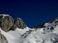
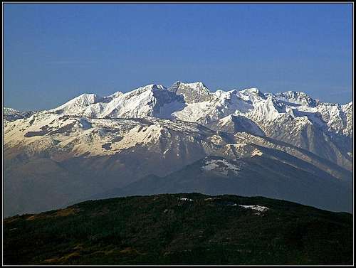 Cimon del Cavallo group from the east
Cimon del Cavallo
Carnic Pre-Alps are sending towards the south a strong streak of mountains and Cimon del Cavallo is the highest summit in the southernmost group. It is surrounded by a handful of 2000-ers, but more towards the south Carnic Alps lower considerably, even if also there one can find nice panoramic summits, like for example Monte Pizzoc. So, another "horse"? Yes, it has a bold posture, this Cavallo, it's head is rising sharply above the neighbouring summits.
No wonder that it is the most important mountain of Pordenone district, clearly distinguishable from any point of Furlania plane. And, you might expect, the panorama from its summit is immense. One would perhaps expect that where Alps are ending, the summist should be already rounded and humble. Not in the case of Cimon del Cavallo. It is not hard to ascend it, but from all sides one must overcome at leas some steep, almost vertical rocky sections. The east wall of Cimon del Cavallo is high and almost vertically falling down into Val Piccola. The predominant rocks of Cimon del Cavallo are upper cretacious limestones.
The whole mountain area is quite close to many towns in Furlania plane, so on beautiful days visitors will not be lacking. The ski resort of Piancavallo on the SE is a huge touristic monster, connected with the valley by a broad, asphalt road. Due to good climate and many outdoor possibilities it is very frequented also in summer. On the other side of the streak there is a more pleasant but also very often visited high valley of Alpago. From both sides ascents are only 1000 meters high or less.
Cimon del Cavallo group is also very nice and popular in times of tour skiing. The summit itself is not appropriate for skiing, but many notches and high valleys in the surroundings are beautiful goals.
Cimon del Cavallo was ascended for the first time in 1726, by two botanists: Giovanni Girolamo Zannichelli and Domenico Pietro Stefanelli. In their chronicles we read how they started near Aviano, reached by mules the high meadows of Piancavallo, where they stayed with local shepherds. After performing some botanical research, which was their first objective, they undertook the ascent, which they found as very steep, requiring climbing. However, their report focuses mainly on botanics. They were so enthusiastic about the rich flora that they named the area "Giardino della Madonna", "The Garden of Virgin", full of unknown and miraculous plants. One of the best local climbers from the classical era of 6th degree (sesto gradi) was Raffaele "Biri" Carlesso, 1908-2000.

A Short Geographical Description
The summit of Cimon del Cavallo rises in the center of a small group. From the north, the main crest comes. The nearby Cimon d'Alpago (or Cima Laste) is already almost as high as Cimon del Cavallo, both summits are connected by a high ridge. From Cima Laste towards the west a short ridge descends to Forcella Laste. Just below it there's the only mountain hut in the group. West of Forcella Laste there is Monte Castelat, 2208 m, subgroup. From Cimon del Cavallo the main ridge continues southwards - first down on Forcella Palantina, then on Cimon di Palantina and further on. Towards the south-east from Cimon del Cavallo a side ridge deters. Beyond Forcella Furlani there is Cimon dei Furlani, then the grassy ridge lowers down towards the Piancavallo plateau. All sides of Cimon del Cavallo summit structure are mostly rocky. The southern face of the summit cone shows steep rocks, intermitted with grass. Rocky, rugged and less grassy is also the western face. Yet, also this is not a solid rock wall. But towards the east from the summit of Cimon del Cavallo an almost vertical, solid, 400 meters high rock wall is falling down into Val Piccola. Together with the walls of Cimon dei Furlani (north) and Cima Laste it forms a beautiful end above a high valley.
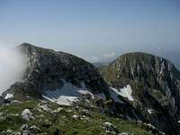
 Cimon del Cavallo Cimon del Cavallo |
 Cimon di Palantina Cimon di Palantina |
 Cima Laste Cima Laste |
Summit Panorama
As of panoramas, the most beautiful on Cimon del Cavallo are the long distance ones. The nearby landscape is nice too, but nothing so very special. In a very clear day I was surprised to see above the Adriatic the very distant Učka mountain - in Croatia. Julian Alps were already expected and the eastern part of Carnic Alps as well. Not much was seen beyond the main Carnic Alps Ridge (Karnischer Hauptkamm), as we are already very much to the south. On the other side of Cellina river valley the southern walls of Carnic Pre-Alps are impressive - from Monte Raut to Monte Ressetum. From behind them, the highest peaks of the group are peeking out. The western side of Carnic Alps shows its wild nature - as allways - Duranno, Cima dei Preti and others. Dolomites are well seen, their southern part, of course and towards the west the hills of other Pre-Alps. More nerby, towards the north the ridge is running towards Monte Messer, Crep Nudo and Col Nudo. From the first attempt on Cimon del Cavallo I expected to be able to admire from its top the view on Venice, its channels, San Marco and Dodge Pallace. Nothing of that, of course. It's still too distant and too much towards the south - towards the sun. While more towards the east Adriatic sea was clearly seen, the Lagoons of Venice were shrouded in mist.
 N views N views |
 Across Furlania plane Across Furlania plane |
 Towards the SE Towards the SE |
Getting There
Cimon del Cavallo is equally well ascended from the eastern and from the western side. The former is a bit shorter.
 Piancavallo
1. Piancavallo tourist resort can be reached by a good, broad road from Aviano. On Piancavallo there are many trailheads, all paths are marked. Once there was a passable road on Piancavallo also from Barcis, so from the north. On our first attempt we drove there, but in 2010 (October) the road was closed for public traffic.
2. Alpago high valley lies on the western side of the massif. It can be reached by many roads from Belluno (there you exit the highway from Venice and Treviso), or the local road which connects Belluno with Vittorio Veneto. One starting point for tours from Alpago is Malga Pian delle Lastre, 1250 m, from where two marked paths go to Rif. Semenza. The other starting point is Casera Pal, 1054 m, on the north-west, also a trailhead for Rif. Semenza. There are more trailheads (on the south-west), but lower than the mentioned ones.
Routes Overview
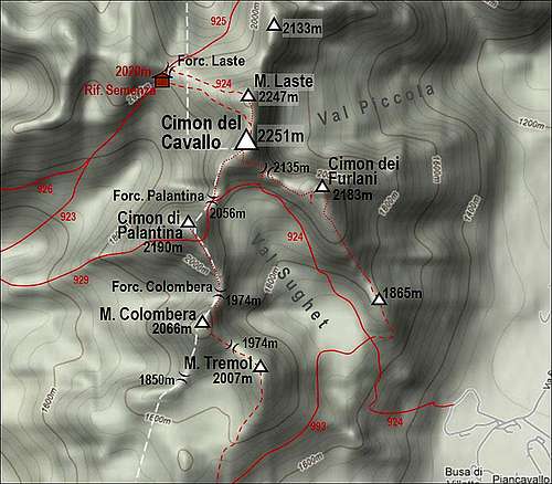 A self-made sketch o Cimon del Cavallo group and some of its marked paths
Summer hikes, scrambles and ferratas
1. The southern approach from Val Sughet. Italian grading: EE, II-. From Piancavallo we go (path No. 924) towards the NW and then N into Val Sughet. We ascend through the valley by its eastern side, reaching below the south face of Cimon del Cavallo. Easy hike up till there. From there we have two options: a. On Forcella dei Furlani, then by the distinct ledge westwards into the S wall and by a steep rocky ravine (all the time steel cable) on top. Easy ferrata. b. Further towards the west on Forcella Palantina, then by the main ridge towards the N and NE on top. Easy ferrata and unprotected sections (easy climbing up to UIAA I+). In both cases it's some 950 altitude meters, 2 h 45 min. The overall grading EE is reasonable, but UIAA II- is a bit exaggerated. Description in Italian: http://www.vienormali.it/montagna/cima_scheda.asp?cod=393
2. Altavia dei Rondoi - over Cimon dei Furlani. As above #1, but in the lower part of Val Sughet (on 1700 m) on the crossroads turn right and ascend the SE fore-summit (1865 m) of Cima dei Furlani. Then by the ridge down on a small saddle and up on Cimon dei Furlani, 2183 m. Downclimbing (UIAA II-, not protected) you then descend its W face and cross on Forcella dei Furlani. From there by the ledge into the S face of Cimon del Cavallo and by a steep rocky ravine (all the time steel cable) on top. Marked, UIAA II- in downclimbing. 1050 m, 3 h 30 min. Remark: The whole Altavia dei Rondoi is a marked route which encircles the high Val Sughet and visits 5 summits: Monte Tremol, 2001 m, Monte Colombera, 2066 m, Cimon di Palantina, 2190 m, Cimon del Cavallo, 2251 m and Cimon dei Furlani, 2183 m. Very nice and panoramic route, 5 h 30 min, passages up to UIAA II-. If we go clockwise, harder sections are: Monte Colombera descent and Cimon dei Furlani ascent. Description in Italian: http://www.cai.pordenone.it/strutture/percorsi/percorsi-rondoi.htm
3. Through Val Grande. Italian grading: EEA. The trailhead is also on Piancavallo plateau, but more towards the north, on Casera Pian delle More, 1193 m. By Sorgente del Tornidor we go by the marked path No. 925 towards the NW, then towards the W into the high Val Grande. The path goes first by the bottom of the valley, then by its steep left side. So we reach Forcella Val Grande, 1936 m. From the notch we cross over towards the SW on Forcella Laste and then by the ridge on Monte Laste. Then by the main connection ridge towards the S on top. 1100 m, 4 h.
4. From Rifugio Semenza. Italian grading: EEA. From Malga Pian delle Lastre, on Alpago, you go to Rif. Semenza . 2 h 15 min till here, easy. From the hut you have two options: either below the walls towards the east on the main ridge, or to Forcella Laste and then towards the E on Monte Laste. The ridge from Monte Laste to Cimon del Cavallo is at first easy, the last part has a few exposed and almost vertical rocky sections which are protected by a steel cable. 1000 m, 3 h altogether, 45 min from the hut. Description in Italian: http://www.vienormali.it/montagna/cima_scheda.asp?cod=75
5. From the south by the main ridge. Italian grading: EE, II-. It is also possible (but longer) to go from Piancavallo by ski pistes towards the W and then on Cima Colombera by its southern slopes. Then all the time towards the north, below Cimon di Palantina (you can ascend it too) on Forcella Palantina and on top. Some 4 hours.
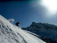
Ski Tours
 On Forcella Valgrande
 In Valgrande
The summit of Cimon del Cavallo is not a goal of tour skiers. It falls with at least some rock sections on all sides. Otherwise the whole area is very popular for tour skiing, especially because of comfortable winter approaches. Below is a list of just the most popular ski routes in the vicinity:
In the southern part of the group there is an ordinary ski resort. But from Piancavallo or from the upper station of the chair lift in Valle di Sass, Monte Tremol, 2007 m, can be reached with skis. Skiing from the top is possible either towards the SW, SE or NE (in the lower Val Sughet).
From Casera Palantina, on the western side of the ridge, reachable from Alpago, ski tours go on Forcella La Palantina, 1778 m, Forcella La Palantina alta, 1850 m, and further on Monte Colombera, 2066 m. From this summit you ski down by the approach route (southwards). Casera Palantina is also the starting point of the ski tour on Cimon di Palantina, 2190 m. The tour goes by the W-SW ridge.
From Piancavallo you can go with skis in the upper end of Val Sughet valley. There you can choose either Forcella Palantina, 2055 m, or even Cimon di Palantina, 2190 m, by it southern slope.
From Alpago, you can ascend with skis Rifugio Semenza (SW approach and N approach). From Forcella Laste just above the hut, you can continue westwards by the ridge on Monte Laste, 2247 m. See the route description: Cima Lastè Ski Route – Alpago!
Map Tabacco, 1:25000, No. 012: ALPAGO - CANSIGLIO - PIANCAVALLO - VALCELLINA
Only Our Third Attempt Was Successful
Many years ago we came on Piancavallo to ascend this panoramic summit. We underestimated the tour a bit, but that was less important than the fact that we rushed in a wrong direction. Up the ski slope, then over steep grassy slopes, finally we lost the trail. It was such a warm autumn day, so we took a nap, believing that we are close to the summit. When we ascended the panoramic grassy peak nerby, higher summits appeared on the north. We didn't have a clue where we were, we knew only that if Cimon del Cavallo is the highest one, it must had been quite far away. And it's a long drive home...
The second attempt was even more naive, even if we were much more determined to succeed. It was end of March. With friends we did a superbe 2-days bike around Venice (by lagoons), then they went home and we slept on Piancavallo. Next morning we corrected the direction, still having no detailed map. We walked over the Piancavallo plateau towards the north, saw the nice eastern walls of Cimon del Cavallo and soon afterwards started to ascend up the valley by a marked path. It was a nice day, but the path went much to the right, then all the way up Val Grande on Forcella Val Grande. Even before the saddle I knew our chances were getting close to zero. Snow was still soft, but in the direction of Cimon del Cavallo we were looking on its northern slopes. On the saddle it became obvious. No chance, because we had no winter equipment, of course.
We were on a biking tour. When returning from the second attempt, I took a picture of the big pano, showing the area. But for the third attempt we did not take it with us. Nor did we need it, because Jasmina had it clearly in her memory. Immediately we hit the right trailhead (there was a map on pano too) and success had to come. But only after we carefully descended the steep slope of Cimon dei Furlani...
Mountain Huts
 MOP - Rif. Semenza
 Monte Castelat and Rif. Semenza
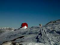 MOP - Winter bivouac
Rifugio Semenza, 2020 m. Reachable in 2 h 15 min from Alpago, from Pian delle Lastre or from Casera Pal (paths No. 926, 923 and 924). Phone in the hut: 0437 49055. Cell phone: 349 1881250. E-mail: rifugiosemenza@libero.it. Usually opened from June 15th to September 15th.
In winter, on the other side of Forcella Laste there is a bivouac with 9 beds. Web page: http://www.rifugiosemenza.it/ On Piancavallo and Alpago there are many hotels.
Red Tape
No restrictions.
When to Ascend?
Cimon del Cavallo can best be ascended in dry season - June till October. Mountain spring is beautiful in this area, as grassy slopes are abundant with southern alpine flora. In winter conditions a full winter equipment is needed, because not all sections of routes are protected with steel cables. The surrounding summits, notches and high valleys are beautiful goals for tour skiing.
Your Help Is Needed
- Do you have information about climbing in the big E wall of Cimon del Cavallo?
- Do you have experience with the ascent from Rif. Semenza?
- Any winter experiences with Cimon del Cavallo?
- Any ski touring experiences in the neighbourhood?