

-
 24373 Hits
-
 83.69% Score
-
 17 Votes
|
|
Mountain/Rock |
|---|---|
|
|
34.32560°N / 118.2192°W |
|
|
Los Angeles |
|
|
Hiking |
|
|
Spring, Fall, Winter |
|
|
5440 ft / 1658 m |
|
|
Overview
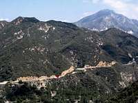
 Condor Peak from just below Fox Peak.
Condor Peak stands high above Big Tujunga Canyon, across from Mount Lukens, and west of Josephine Peak. On a clear day it commands superb views of the western San Gabriel Mountains. If you come in the spring when the Ceanothus is in bloom, you will be treated to a show of beautiful lilac-colored flowers.
The peak is named after the endangered California Condor. A hundred years ago it was a nesting ground for the huge birds, and they could be seen wheeling gracefully overhead in search of something dead to eat. Sadly, the condor's numbers have declined dramatically. The last condor sighting in the area was before World War II.
Getting There
From south of the San Gabriels you will need to find your way to I-210. If coming from the east, exit at Lowell, pass under the freeway and continue on up to Foothill Blvd. Turn left. After a few miles touring the lovely Sunland/Tujunga area you will come to Mt. Gleason Road. Turn right. Follow Mt. Gleason Road to its end at Big Tujunga Canyon Road. Turn right. Condor Peak trailheads are a few miles further. See detail below.From the west, exit I-210 at Sunland Blvd. Go about a mile on Sunland (which soon joins and becomes Foothill blvd) to Oro Vista avenue (Jack in the Box on corner), turn left, after about a mile Oro Vista enters Big Tujunga canyon, and about another mile later at the intersection with Mt. Gleason Avenue it becomes Big Tujunga Canyon Road. The trailheads are a few miles further (see below).
If you're coming from the north (i.e., Antelope Valley), exit Highway 14 a few miles south of Palmdale at the Angeles Forest Highway exit. Take Angeles Forest until you reach Big Tujunga Canyon Road. Turn right at Big Tujunga Canyon Road. The first trailhead you will come to is at Mile marker 5.82, about a mile past the grand old bridge spanning the river. An alternate to this TH is at mile marker 4.50. Or, continue a bit further to Trail Canyon Road (see Trail Canyon Route below).
Routes
| Route | Distance/gain | Description/Comments |
|---|---|---|
| Via Trail Canyon | ~16 mi R/T, 4,000' gain | This trail follows Trail Canyon to its head. It is lush with plants and trees such as Sycamore, Bay, and Oak. The first few miles are popular with day hikers. Near mile marker 2.01 on Big Tujunga Canyon Road you will find the turn off to Upper Trail Canyon Road, a dirt road easily passable by 2WD passenger car. Follow the road a short distance to it end. The trail starts on a gated dirt road that provides access to some private cabins. After a maybe half a mile the road makes a 180 degree turn back toward the last cabin. A trail drops steeply a short distance down from this turn into the canyon bottom. The trail can be hard to follow where it meanders across the streambed. Don't go too far if you think you're off track. Follow this for about five miles until you reach a saddle on the east-west ridge connecting Iron Mountain (the huge reddish mass to the west) and Condor Peak. There are trail signs here. Take the Condor Peak Trail east for a couple of miles until you find a use trail leading the last few hundred feet up the peak (the Condor Peak Trail contours below and to the north of the summit). If you are interested in camping in the back country, Tom Lucas trail camp is about 3.8 miles up. It's a bit overgrown and easy to miss. Look for picnic tables and a fire pit. |
 | ||
| From the South via the Condor Peak Trail | ~17 mi R/T, 4,000' gain | My personal favorite. The Condor Peak trail winds its way up the south side of the mountain, passing through a rich chaparral landscape, crossing several canyons and presenting the hiker with a variety of views. A great hike if it isn't too warm. There are views the whole way, and the trail, except for the last mile or so, is well-graded and maintained. The Sierra Club's HPS has driving directions on the web, and they're correct as far as they go. However, starting at mile marker 5.82 on Big Tujunga Canyon Road (as they suggest) adds at least two miles and 400 feet of gain to the round trip. A better start is at mile marker 4.50. There is parking nearby. Follow the trail up and east about a quarter mile until you reach a trail that heads back and up to the west. That's your trail. Follow it to a ridge just below and west of Fox Peak, then head west along the ridge. Pass over a very disappointing false summit, drop down into the next saddle, then take a use trail straight up to the summit (the Condor Peak trail skirts the summit on the north). |
 | ||
| From the North via the Condor Peak Trail | ~10 mi R/T, 2,400' gain | This route involves several miles of approach on dirt roads, followed by a few more miles walking on roads until you come to the Condor Peak Trail (itself an abandoned fire road). See the Sierra Club's HPS route description. |
Red Tape
Condor Peak lies within the Angeles National Forest . A National Forest Adventure Pass or Golden Eagle pass is required to park in the ANF. Annual passes are $30, and day passes are $5. Passes can be purchased at Forest Service offices and virtually any sporting goods store in Southern California. No permits are required for hiking or camping.Camping
The closest developed camping is the Monte Cristo Campground.Located off Angeles Forest Hwy. 9 miles north of the Angeles Crest Hwy. intersection.
Backpackers can camp anywhere they want or at Tom Lucas trail camp, about 3.8 miles up on the Trail Canyon trail.
The Angeles National Forest has many other campgrounds, check out their web site for more details.
When to Climb
Condor Peak is probably best climbed fall through spring; summer days can be blazing hot. There may be summer water lower down in Trail Canyon, but other than that it's best to assume you will not find water on your hike.Weather forecasts for Mount Wilson, which lies a few miles to the east, are easily obtainable in Southern California newspapers and on line. Mount Wilson conditions are a good proxy for Condor Peak.
Ticks and Poison Oak
Two hazards you may encounter on the trail.Ticks are out mostly in the moist cooler months, especially in the spring. Avoid brushing against grass and branches along side the trail. Ticks will cling onto your skin and clothing. Check frequently for these slow moving parasites.
Poison Oak is plentiful in riparian areas, know what it looks like and don't touch it.
Additional Information
USFS websiteNational Forest information.
Field Guide to
the San Gabriel Mountains
An excellent website packed with information about the San Gabriel Mountains.
Trail Canyon Trail
Some interesting trivia.
Angeles Chapter HPS Condor Peak listing A good source for information.