
-
 8418 Hits
-
 86.37% Score
-
 22 Votes
|
|
Mountain/Rock |
|---|---|
|
|
46.13499°N / 10.58636°E |
|
|
Trentino |
|
|
Mountaineering |
|
|
Summer |
|
|
11161 ft / 3402 m |
|
|
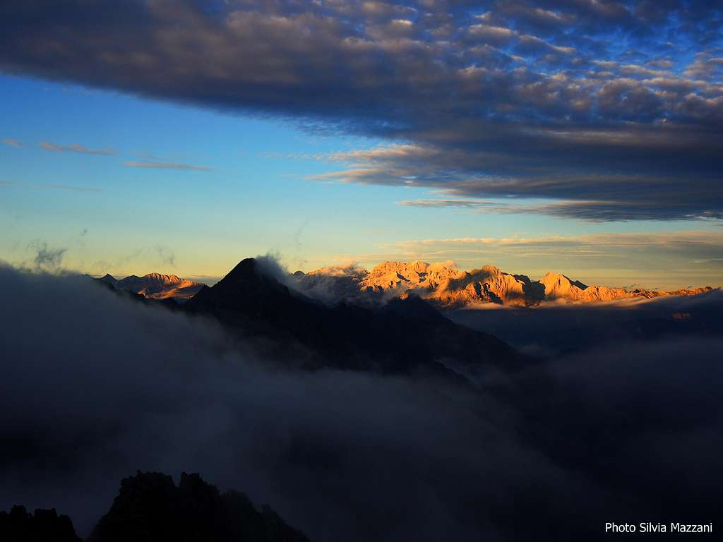
Overview
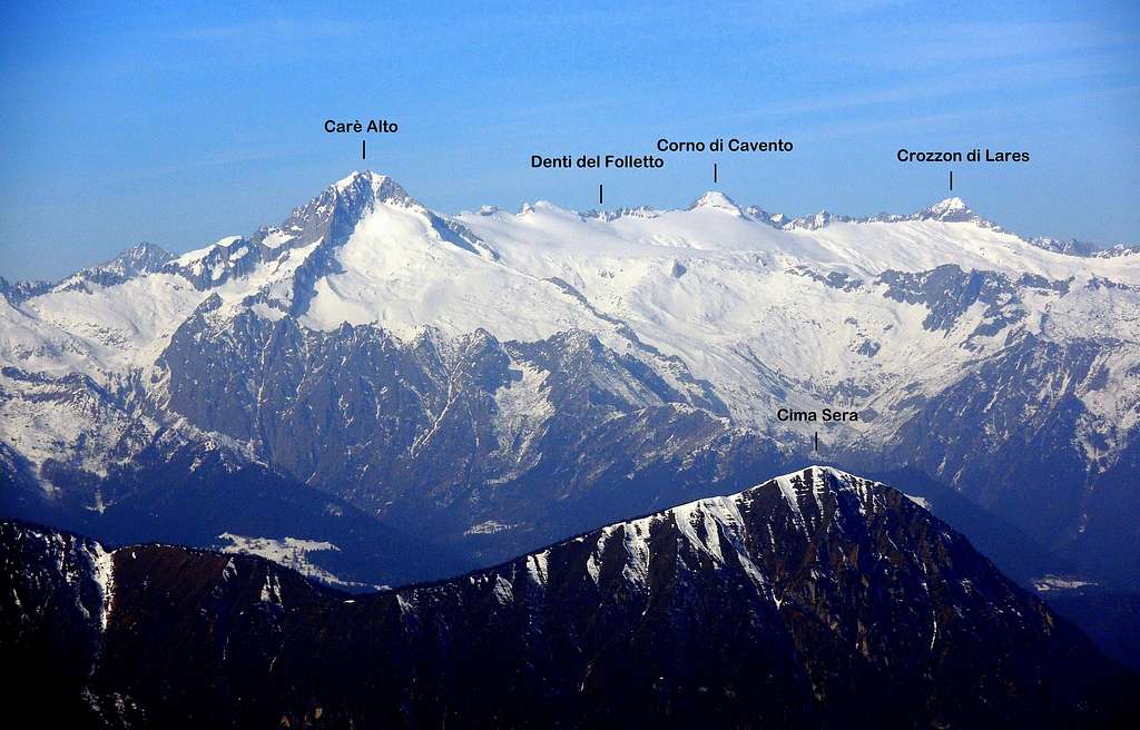
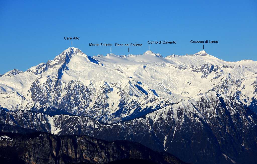
Geographical classification: Alps - Eastern part > Rhaetian Alps > Adamello Group > Corno di Cavento
Corno di Cavento 3402 m
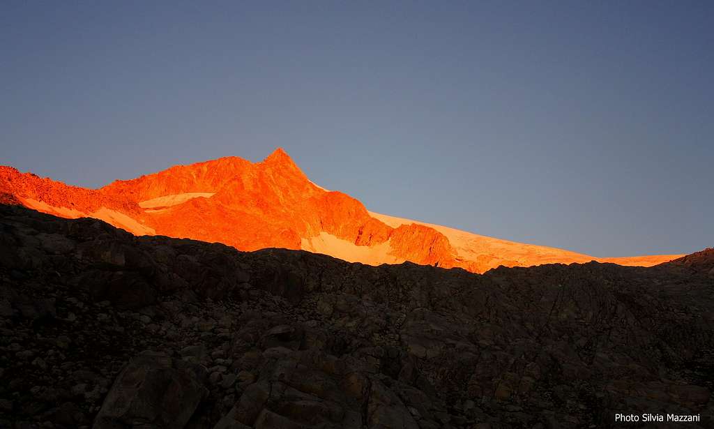
Corno di Cavento 3402 m is a fine pyramid-shaped peak, belonging to the Adamello Group, Subgroup Carè Alto. It’s located between Passo di Cavento and Denti del Folletto, along the ridge running from Carè Alto to Val di Genova and separating the glacier named Vedretta di Lares (East) from the upper Val di Fumo and Vedretta della Lobbia ("vedretta" means "small glacier").

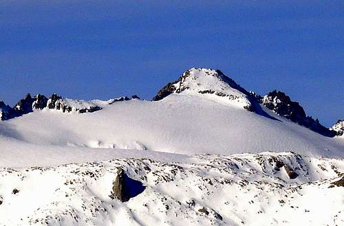
Corno di Cavento is surrounded by the glaciers: Vedretta di Lares to the East and the broad Vedretta della Lobbia to the Northwest. To the North Corno di Cavento shows a ridge descending directly to the Passo Cavento (3191 m). The peak is particularly majestic when viewed from the Western and Southern sides. In fact the West wall is high and graven by some steep icy gullies, giving it an impressive appearance, moreover it's diveded into two parts by the long WSW ridge. On the contrary, Corno di Cavento Eastern side rises from the Vedretta di Lares with a short snowy slope, rocky in late summer. It’s just on this side where it’s located the Normal route, virtually the only route nowadays attended to reach this beautiful summit, full of history.
Despite the modest appearance of the mountain from this side, the environment is still wild and fascinating and the ascent absolutely worthwhile. The interest of this route, that presents low technical difficulties, is due above all to the beautiful glacial environment and to the historical interest of the mountain, which was the scene of fierce fighting during the WWI. The place name Cavento - meaning "home of wind" - refers to the frequent adverse weather peculiar of this zone. The first ascent was carried out by the Bohemian mountaineer and explorer Julius von Payer with Coronna, Griesmayer and Haller on 3 September 1868. On the same day they also made the first known ascent of the nearby Crozzon di Lares.
|
|
Il Corno di Cavento 3402 m è una montagna a forma piramidale situata nel gruppo dell'Adamello, sottogruppo Carè Alto. Sorge tra il Passo di Cavento e i Denti del Folletto, lungo la dorsale che va dal Carè Alto alla Val di Genova e separa la Vedretta di Lares (Est) dall'alta Val di Fumo e dalla Vedretta della Lobbia ("vedretta" significa "piccolo ghiacciaio"). Il Corno di Cavento è circondato dai ghiacciai: ad Est la Vedretta di Lares e a Nord-Ovest l'ampia Vedretta della Lobbia. A nord il Corno di Cavento presenta una dorsale che scende direttamente al Passo Cavento (3191 m). La montagna è particolarmente maestosa se osservata dai lati occidentale e meridionale. In effetti la parete Ovest è alta e incisa da alcuni ripidi canali, che le conferiscono un aspetto imponente. A circa metà è divisa in due parti dal lungo crestone WSW. Al contrario il versante orientale del Corno di Cavento sorge dalla Vedretta di Lares con un breve pendio nevoso, roccioso a fine estate. È proprio da questo lato dove sale la via normale, praticamente l'unica via percorsa oggi per raggiungere questa splendida vetta ricca di storia. Nonostante da questo versante la montagna presenti un aspetto piuttosto modesto, l'ambiente è selvaggio e affascinante e la salita assolutamente da non perdere. L'interesse di questo percorso, che presenta scarse difficoltà tecniche, è dovuto soprattutto al bellissimo ambiente glaciale e all'interesse storico della montagna, teatro di aspri combattimenti durante la Prima Guerra Mondiale. Il nome di luogo "Cavento" - ossia "casa del vento" - si riferisce al clima avverso molto frequente di questa zona. La prima ascensione fu effettuata dall'alpinista ed esploratore boemo Julius von Payer con Coronna, Griesmayer e Haller il 3 settembre 1868. Lo stesso giorno gli stessi fecero anche la prima salita nota del vicino Crozzon di Lares.
Getting There
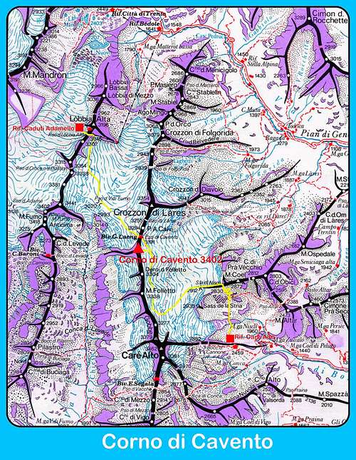
You can choose between two different ways to approach Corno di Cavento Normal route, both rather long and starting from Val Rendena: starting from Rifugio Carè Alto or from Rifugio Ai Caduti dell’Adamello. The final part of the climb to the summit from Vedretta di Lares is the same for both itineraries.


Road access to Val Rendena
Coming from Autobrennero exit Trento and take the road to Riva del Garda, reaching the village Le Sarche. Here continue straight toward Tione di Trento.
Road approach to Rifugio Carè Alto - In Tione turn to right and take the SS 239 Val Rendena route towards Pinzolo and Madonna di Campiglio, reaching Villa Rendena, Vigo Rendena, Pelugo and Borzago. In Borzago leave the main road 239 and take on the left the road entering Val di Borzago (signposts Rifugio Carè Alto), reaching the small hamlet of Case di Fe 1087 m, then Pian della Sega (7 km. from Borzago), where you must park the car (wide parking lot). A gravel road continues up for a few kilometers, but it’s close to private cars.


Road approach to Rifugio Caduti dell’Adamello - In Tione turn to right and take the SS 239 Val Rendena route towards Pinzolo and Madonna di Campiglio, reaching Villa Rendena, Vigo Rendena, Pelugo, Borzago, Pinzolo and Carisolo. Pass Carisolo 806 m and take on the left the road entering Val di Genova. Follow entirely the road getting to Malga Bedole. In summer the access by private car beyond Ponte Verde - near the Nardis Waterfall - is regulated (toll or public shuttle). More info: Val di Genova
The WWI on Corno di Cavento
The Adamello Group was one of the main mountain ranges of the Alps where it was fought the WWI between the Italian and Austrian troops. In fact, the ancient border between Italy and Austria ran along this chain. In particular the summit of Corno di Cavento was the scene of bloody battles and heroic deeds by Austrian and Italian soldiers during the war.

It has become legendary the Austrian Lieutenant Felix Hecht and his war diary from the Corno di Cavento. On June 15, 1917, during the Italian assault conducted to the summit of the Cavento, the young commander died before the Austrian garrison withdrew from the summit, leaving it to the Italians. His body was never found. Impressive ruins are located on the mountain near the summit, among these latter the Austrian war cave. The existence of the tunnel built by the Austro-Hungarian Empire was known, but its discovery dates back only a few years ago. After the end of the war the cave was visited by recovering of war material, but later it filled up with ice and snow, that sealed it for many years. Only after the hot summer of 2003 and during the following years the thickness of the inner ice decreased, allowing the entrance in the cave. It was carried out a restoration project, during which specimens of all kinds were found exactly as they were left almost a hundred years ago, after the descent of the last Italian soldiers who occupied the cave. Hundreds of war relics were recovered and cataloged. With a development of some tens of meters the cave housed about 40 soldiers, with straw mattresses for the night, a rudimentary kitchen, a comfortable small room for officers, an office bays for logistics and services. This strategic location was repeatedly lost and regained by Austrians and Italians and was then inhabited several times under different flags. The cave of Corno di Cavento represents an exceptional war testimony. Since summer 2011, the cave was made accessible with guided tours, organized by Società Alpinisti Tridentini (S.A.T.) by reservation. More historical info: Lo Scarpone - CAI Trentino Grande Guerra Società degli Alpinisti Tridentini - Via Manci, 57 - 38100 Trento Phone: +39 0461 981871 sat@sat.tn.it | www.sat.tn.it

WWI memorial plaque on Corno di Cavento |

WWI cave on Corno di Cavento |
Il Gruppo dell'Adamello fu una delle principali catene montuose delle Alpi dove fu combattuta la Prima Guerra Mondiale tra le truppe italiane e quelle austriache; infatti, l'antica frontiera tra i paesi correva lungo questa catena. In particolare la vetta del Corno di Cavento fu teatro di sanguinose battaglie ed eroiche imprese di soldati austriaci e italiani. Sono diventati leggendari il luogotenente austriaco Felix Hecht e il suo diario di guerra dal Corno di Cavento. Il 15 giugno 1917, durante l'assalto italiano condotto alla cima del Cavento, il giovane comandante morì prima che la guarnigione austriaca si ritirasse dalla cima, lasciandola agli italiani. Il suo corpo non fu mai ritrovato. Impressionanti resti bellici si trovano sulla montagna vicino alla vetta, tra esse la caverna di guerra austriaca. L'esistenza del tunnel costruito dall'impero austro-ungarico era nota, ma la sua scoperta risale a pochi anni fa. Dopo la fine della guerra la caverna venne visitata e venne recuperato del materiale bellico, ma in seguito si riempì di ghiaccio e neve e rimase chiusa per molti anni. Solo dopo la calda estate del 2003 e negli anni seguenti lo spessore di ghiaccio all'interno diminuì, permettendo l'ingresso nella caverna. Fu realizzato un progetto di restauro, durante il quale furono trovati oggetti di ogni tipo esattamente come erano stati lasciati quasi cento anni prima, dopo la discesa degli ultimi soldati italiani che occuparono la grotta. Centinaia di reliquie di guerra furono recuperate e catalogate. Con uno sviluppo di alcune decine di metri, la caverna ospitava una quarantina di soldati. Vennero ritrovati materassi di paglia per la notte, una cucina rudimentale, una comoda cameretta per gli ufficiali, un ufficio per la logistica e i servizi. Questa posizione strategica fu ripetutamente persa e riconquistata da austriaci e italiani e fu abitata più volte sotto bandiere diverse. La caverna del Corno di Cavento rappresenta un'eccezionale testimonianza di guerra. Dall'estate 2011, la grotta è stata resa accessibile con visite guidate, organizzate dalla Società Alpinisti Tridentini (S.A.T.) su prenotazione. Altre informazioni storiche: Lo Scarpone - CAI Trentino Grande Guerra Società degli Alpinisti Tridentini - Via Manci, 57 - 38100 Trento Telefono: +39 0461 981871 sat@sat.tn.it | www.sat.tn.it
Huts


- Rifugio Carè Alto-Dante Ongari 2459 m
Situation: East ridge of Carè Alto, on the side of Val Conca (Val di Borzago)
Open: from June 20th to September 20th
Size: 82 persons Winter-shelter: 8 persons
Owner: SAT Trento
Guardian: Marco Bosetti and family
Refuge's phone: +39 348 4359097 - +39 340 2943731
Walking approach - From the parking lot Pian della Sega in Val di Borzago (m 1250) take the old mule track through the woods and follow it until the alp Coel di Pelugo 1440 m. (30 minutes) from where it starts the cable car to the refuge. Take the path SAT 213 rising along steep turns, reach a tibetan bridge on a stream (rio Bedù di Pelugo), cross it and rise to the plateau above, traverse left and walk up the large rocky step, getting to the refuge (3,30 hours from Pian della Sega, difference in level 1200 m).
Corno di Cavento seen from Rifugio Ai Caduti dell'Adamello
- Rifugio Ai Caduti dell'Adamello alla Lobbia 3040 m
Situation: Western slopes of Lobbia Alta, on the sidelines of Vedretta Mandron
Open: summer from June 20th to September 20th - winter from March 5th to May 1st
Size: 100 persons
Owner: CAI Brescia
Guardian: Romano Bertero Ceschini
Phone: +390465502615 Mobile: +393356664234
Walking approach - From Refuge Bedole take the path n. 212 that crossing a stream (rio Ronchina) rises with many hairpins reaching Crozzetti 2253 m, the junction with the "Migotti" path n. 220. Keep left and proceed with less steeply, passing near the old Rifugio Mandron 2429 m and arrive in a few minutes to the new Rifugio Mandron. From here follow the trail No. 236 that skirting the Mandron lakes leads to the foot of the Glacier of Mandrone. Go up the moraine, snow and debris along the left side bank of the glacier until around 2800 m, where you turn left (signposts Rifugio Lobbia Alta), crossing the glacier to SE and reaching the refuge.
Corno di Cavento Normal routes
Corno di Cavento from Rifugio Carè Alto
Summit altitude: m 3402
Difficulty: Alpine F
Difference in level: 1000 m
Exposure: East
Hut: Rifugio Carè Alto m 2459
Beautiful and very panoramic route that reaches the summit along the easy SE ridge, after crossing the Vedretta di Lares, which involves the use of glacier gear.
Route report - From Rifugio Carè Alto - Dante Ongari take the path n. 215 starting just behind the building and descending the rock staircase of “Bus del Gat”. The good path stars to cross the basin below Vedretta di Niscli and soon gets a stream, the Rio Bedù.
A characteristic cable bridge allows to cross the stream. The trail continues to rise up the valley along the moraine reaching Sasso Bagnato, where there is a junction.

The main trail goes right to Passo Altar, we keep the left and continue up a moraine ridge reaching Pozzoni rocky band overlooking the small namesake lakes and Sella di Niscli 2912 m. (signposts).
Soon you reach the beginning of the glacier (Vedretta di Lares); rope up and start climbing the glacier Westward, at first more gently, then more steeply already in sight of Denti del Folletto and rightmost Corno di Cavento. At a certain point the itinerary turns to right, reaching a light hollow near Denti del Folletto.
Continue to skirt these bizarre rocky teeth, finally reaching the base of Corno di Cavento SE side. Climb up snow cones (earlier in the season) and easy granite boulders, getting the entrance of the war cave. Head slanting left, getting quickly the beautiful summit.

|

|
Descent: reversing the route
Versione italiana
Via bellissima e molto panoramica, raggiunge la vetta lungo la facile cresta Sud-Est, dopo aver attraversato la Vedretta di Lares, che prevede l'uso dell'attrezzatura da ghiacciaio. Dal Rifugio Carè Alto - Dante Ongari prendere il sentiero n. 215 partendo proprio dietro l'edificio e scendendo la scala di roccia del "Bus del Gat". Il sentiero inizia ad attraversare la conca sotto la Vedretta di Niscli e presto arriva un torrente, il Rio Bedù. Un ponte a cavo caratteristico consente di attraversare il torrente. Il sentiero continua a salire lungo la valle lungo la morena raggiungendo il Sasso Bagnato, dove si trova un bivio. Il sentiero principale prosegue a destra verso il Passo Altar, noi manteniamo la sinistra e proseguiamo su una cresta morenica raggiungendo la fascia rocciosa di Pozzoni che domina i piccoli laghi omonimi e la Sella di Niscli 2912 m. (segnaletica). Rapidamente si raggiunge l'inizio del ghiacciaio (Vedretta di Lares); si inizia a percorrere il ghiacciaio verso ovest, dapprima più dolcemente, poi più ripidamente già in vista dei Denti del Folletto e del Corno di Cavento più a destra. Ad un certo punto l'itinerario gira a destra, raggiungendo un leggero avallamento nei pressi dei Denti del Folletto. Si continua a costeggiare questi bizzarri denti rocciosi, raggiungendo infine la base del versante SE del Corno di Cavento. Salire sui pendii di neve (ad inizio della stagione) e sui facili massi di granito, raggiungendo l'ingresso della grotta di guerra. Di qui ci si dirige a sinistra raggiungendo rapidamente la bella vetta del Corno.
Discesa: per lo stesso itinerario

Corno di Cavento from Rifugio ai Caduti dell'Adamello
Summit altitude: m 3402
Difficulty: Alpine F
Difference in level: 400 m
Exposure: East
Hut: Rifugio ai Caduti dell'Adamello m 3040
The final part of this itinerary, the South Ridge, is in common with the itinerary from the Rifugio Carè Alto described above and does not involve any technical difficulties, as it's an ascent on easy granite backbone and snow-fields. The mountaineering character of the itinerary is given by the crossing of the Ghiacciaio della Lobbia and Ghiacciaio di Lares and by the crossing of Passo di Cavento, which is however well marked and served by ropes.
Route report - From Rifugio Ai Caduti dell'Adamello climb up to Passo della Lobbia and descend briefly to reach the Vedretta della Lobbia. Cross the glacier downhill towards SSE, losing about 100 m in altitude and getting the Passo di Val di Fumo 2939 m (crevasses). From the pass the route continues to the SE and heads to Passo di Cavento 3198 m, an obvious notch between Corno di Cavento and Punta Calvi, where it's situated the Bivacco Laeng. By an easy climbing, well marked and helped by fixed ropes, the route gets the pass, located to the left of a rocky pinnacle. Once reached the col downclimb on the opposite side, always aided by metal ropes and cables, to get the Vedretta di Lares, which must be crossed diagonally to the south. Once on the glacier (crevices) the route crosses almost flat under the NE slope of Corno di Cavento and then bypassing a spur gets the South-East crest. Now climb up on snow fields, debris and granite boulders, as for the previous route, to get the War Cave and the summit.

|

|
Descent: reversing the route
Versione italiana
La parte finale di questo itinerario, la Cresta Sud, è in comune con l'itinerario dal Rifugio Carè Alto sopra descritto e non comporta alcuna difficoltà tecnica, in quanto si tratta di una salita su facile dorsale di granito e pendii di neve. Il carattere alpinistico dell'itinerario è dato dal percorso sul Ghiacciaio della Lobbia e sul Ghiacciaio di Lares e dall'attraversamento del Passo di Cavento, che è comunque ben segnalato e agevolato da corde fisse.
Dal Rifugio Ai Caduti dell'Adamello si sale al Passo della Lobbia e si scende brevemente per raggiungere la Vedretta della Lobbia. Attraversare il ghiacciaio in discesa verso SSE, perdendo circa 100 m di quota e raggiungendo il Passo di Val di Fumo 2939 m (crepacci). Dal passo il percorso prosegue verso sud-est e si dirige verso il Passo di Cavento 3198 m, un'evidente sella tra Corno di Cavento e Punta Calvi, dove si trova il Bivacco Laeng. Con una facile salita, ben segnalata e aiutata da corde fisse, si raggiunge il passo, situato a sinistra di un pinnacolo roccioso. Una volta raggiunta il passo si discende sul lato opposto (corde fisse), giungendo sulla Vedretta di Lares, che deve essere attraversata in diagonale verso sud. Una volta sul ghiacciaio (crepacci) il percorso attraversa quasi pianeggiante sotto il pendio NE del Corno di Cavento e poi scavalcando uno sperone raggiunge la base della cresta sud-est. Ora per facili pendii di neve, detriti e massi di granito, come descritto nel percorso precedente, si raggiunge la grotta di guerra e la cima.
Essential gear
Full glacier gear: rope, ice-axe, crampons
Red Tape

No fees no permits needed and no particular restriction in climbing and hiking. Corno di Cavento is located within Adamello-Brenta Natural Park, the largest protected area in Trentino, established in the year 1967. It's located in Western Trentino and with its 620.51 square kilometers includes the mountain groups of Adamello, Presanella and Brenta Dolomites, separated by Val Rendena. Pay attention to the accessibility of Val di Genova road (usually closed to private cars from 9 to 18).
When to Climb
Best season goes from June to September
Meteo
Guidebooks

"Adamello" Vol. I - Pericle Sacchi Collana Guide dei Monti d'Italia CAI-TCI
Maps
"Adamello - Presanella" - Tabacco scala 1:25000
"Adamello, Val di Fumo, Val di Genova" - Kompass n. 638
"Adamello - Presanella" - 4LAND Alpine Cartography n. 138 1:25.000