
|
|
Mountain/Rock |
|---|---|
|
|
40.74330°N / 110.6925°W |
|
|
Summit |
|
|
Hiking, Mountaineering, Scrambling, Skiing |
|
|
Summer, Fall |
|
|
12642 ft / 3853 m |
|
|
Overview
“Dead Horse Peak” is almost completely unknown, but it is one of the most beautiful peaks in the Uinta Mountains of Utah. It is often known as Deadhorse Peak because of its proximity to Dead Horse Lake and Dead Horse Pass. The peak is viewed fairly frequently from the Dead Horse Lake and Allsop Lake areas; two of the most scenic alpine basins in Utah.Many of the peaks in this area are rugged, and Dead Horse Peak is no exception, especially its north and east sides. The west and south sides are less rugged, but still very steep.
There are many big cliffs on the mountain, but the rock is loose and fractured here and technical climbing is risky. The peak can be reached by several non-technical routes of class 2+ and 3.
Dead Horse Peak is one of the peaks in the area which I saw no signs of previous ascents at late as 1991 (though perhaps others had climbed the peak before then). Needless to say, this peak is seldom climbed.
Crossing the main Uinta Crest between the basins on the north and the south is often straight forward. Crossing from Rock Creek Basin to the Allsop Lake Basin is a big exception. I made once the crossing between the basins using a route over the top of Dead Horse Peak, but it’s not something that I would ever repeat. The spectacular north face of Dead Horse Peak looks unclimbable without a rope, but there is a possible, but very dangerous route (which will not be described on this page).
Like all peaks in the Uinta Mountains, except for Bald Mountain, Dead Horse Peak has no trail to the summit. It is a long way from the nearest road and the area is surrounded by many nice backcountry campsites in the basins. Most people need to take several days (three to four is recommended, depending on the route) to climb this peak. Because there are so many peaks in the immediate area to climb, it is easy to stretch a climbing trip out into several days here.
The Uinta Mountains are one of the few mountain ranges in North America that run east to west rather than north to south. Within the Uinta Mountains are about 2000 lakes, and some 900-1000 are full of trout. Along with the San Juan Mountains in Colorado, the Uinta Mountains have more contiguous area above timberline than any other area in the Continental United States. This is a beautiful area with many lakes, meadows, wildflowers, and some rugged peaks. Solitude is usually easy to come by once you leave the popular fishing holes behind.
The Uinta Mountains are very rugged in the northeast section. Beginning at Hayden Peak and east to Mount Lovenia, the Uinta Mountains are not unlike the Tetons or other ranges. East of Lovenia, the peaks are more gentle, with a few rugged peaks (i.e. Red Castle and Henrys Fork Peak) scattered about until you are as far east as the Henrys Fork/Kings Peak area. East of Kings Peak, the Uinta Mountains become very gentle and the peaks are very rounded with only a few scattered cliffs about.
One thing that makes Utah's 12'ers different, then say most of the Colorado 12'ers (for example), is that the distances from the nearest roads are usually much greater for the Utah 12'ers.
Utah's 12,000+ Foot Peaks With 200+ Feet Prominence
Utah's 12,000+ Foot Peaks With 300+ Feet Prominence
 The beautiful north face of Dead Horse Peak as viewed from Allsop Lake.
Getting There
West Fork Blacks Fork TrailheadFrom the traffic light in Kamas and the intersection of Route 248 and 32, head north 0.1 to SR 150 (Mirror Lake Highway). Turn Right onto SR 150 and follow for 49 miles to FR 058 aka "North Slope Road", turn right onto FR 058 (gravel road) and follow for 16 miles to the 4-way intersection with the West Fork Blacks Fork Road turning south. Turn right and follow the rough dirt road to where it crosses the river. It is highly recommended you park here, no matter what type of vehicle you own. The river crossing is very rough and driving through the meadows along the heavily rutted 4wd road is at best, environmentally insensitive, not to mention damaging to your vehicle.
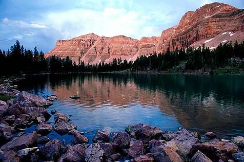 Deadhorse Lake at the head of West Fork Blacks Fork.
Hayden Pass/Highline Trailhead
The best trailhead for the hike is the Highline Trailhead located along State Highway 150 33.2 miles east and north of Kamas, or you could drive south from Evanston. You could also start at Mirror Lake, but you must pay to park there, and there isn't as much room to park.
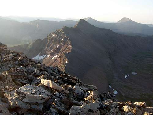
 Upper Rock Creek from the summit of Deadhorse Peak. Explorer and Squaw Peaks, in the background are higher, but less rugged than Dead Horse Peak.
Routes Overview
West Fork Blacks Fork RouteThis isn’t the easiest route, but because it is much shorter than the route from Rock Creek Basin, it would probably be considered the standard route, if there is such a thing on these almost unknown peaks.
The route goes up the beautiful West Fork Blacks Fork drainage to Dead Horse Lake and then climbed the rugged trail to Dead Horse Pass (which the trail often requires an iceaxe into August) before climbing the east ridge of Dead Horse Peak to the summit. Often it is easier to stay on the south of the ridge to avoid some of the more rugged sections. This route can be done in two long days, but three days is best.
 Dead Horse Peak (right) as seen from a tarn above Deadhorse Lake.
Rock Creek Route
This is the easiest route up Dead Horse Peak, but it is much longer than the route from West Fork Blacks Fork and is a 3-4 day trip. This route follows the Highline Trail to Rocky Sea Pass, goes over the pass and to the basin containing Boot Lake and Reconnaissance Lake before climbing to the summit.
The peak is not as rugged from this side, but the area is still full of beautiful peaks, lakes and meadows and is very scenic.
A variation of this route is to come up Rock Creek from Stillwater Reservoir, but that route isn’t quite as scenic and is a bit longer. The basin to the southeast of Dead Horse Peak (containing Continent Lake) could also be used and although longer, might be the easiest route on the mountain.
 This is Dead Horse Peak as viewed from Yard Peak. The Rock Creek side is on the right and is the shadowed face.
Other Routes
As mentioned, there are routes up the peak from Allsop Lake, but they are loose, dangerous, and exposed. Climbing on snow may make things safer if you are well versed in snow climbing.
Red Tape
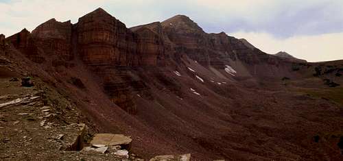
No permits are required. Normal wilderness rules apply. No permits are required. Dead Horse Peak is the slightly lighter colored peak on the left side of the photo just to the right of the buttress.
Camping
Highway 150 has way too many campgrounds to list. All are crowded on summer weekends and holidays. There are many informal campsites around the West Fork Blacks Fork Trailhead.Backcountry campsites are plentiful. Both the West Fork Blacks Fork and Upper Rock Creek areas have plentiful campsites.
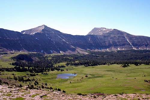 A view of Rock Creek Basin from Dead Horse Pass. As you can see, campsites are plentiful in the basins.
When to Climb
Mid-July through mid-September is the normal climbing season. This peak would be very challenging in winter, and would be a multi-day trip. I know of no winter ascents of the peak, but if you do please, please post any info.In winter, this would be a really long climb because none of the roads to the trailheads are open in the winter.
 Deadhorse Peak in early September.
Mountain Conditions
Contact the ranger station in Kamas for current road and trail conditions. Their phone number is 801-783-4338.Weather Forecast for Central Uinta Mountains
Here are some average highs and lows from the 12,139 foot elevation (3700 meters) in the Uintas (about the same altitude as the summit):
| MONTH | HIGH | LOW |
| JAN | 14 | -1 |
| FEB | 16 | 1 |
| MAR | 19 | 4 |
| APR | 27 | 11 |
| MAY | 35 | 18 |
| JUN | 45 | 25 |
| JUL | 55 | 32 |
| AUG | 53 | 31 |
| SEP | 45 | 24 |
| OCT | 34 | 15 |
| NOV | 22 | 8 |
| DEC | 17 | 3 |