
|
|
Mountain/Rock |
|---|---|
|
|
38.44760°N / 114.6696°W |
|
|
Lincoln |
|
|
Hiking |
|
|
Spring, Summer, Fall, Winter |
|
|
8860 ft / 2701 m |
|
|
Overview
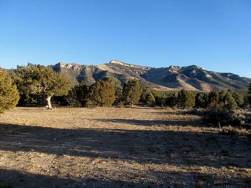
Victor Zhou's nice pic
Dutch John is a unique name for a mountain and may have been named for a miner who had a claim on it. There is nothing I can find about the naming of this mountain so I am speculating of course but being of Dutch ancestry myself, I kind of like the idea it was named after a person from the Netherlands.
Dutch John Mountain has close to 2400 feet of prominence and that makes this one the 120th most prominent mountain in the state of Nevada.
This mountain has outstanding access, it is just barely off of US 93 and even a sedan can get fairly close and although it is about 40 miles north of Pioche, it is nice to have a mountain in Nevada that you can climb without spending an hour or more on dirt roads.
The mountain is very striking as you approach it from the north, it dominates your view for many miles as you get closer and as you get closer, it just keeps getting bigger. Even my wife said "Wow" when she saw it the first time.
Getting There
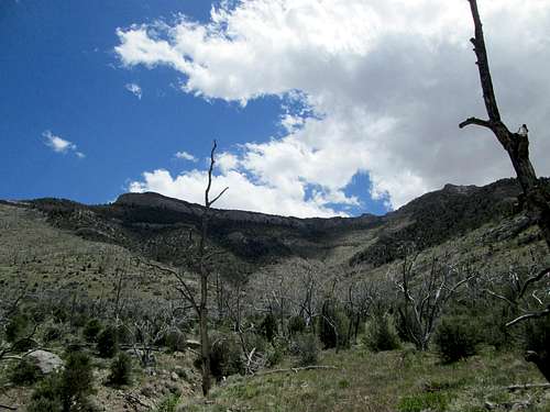
Looking at the west side
From Ely, head south on US 93 (fill up on gas) almost 70 miles to Muleshoe road. Coordinates are 38.4664 113.6450 (elev 6000 nad 27). Turn onto the dirt road and take it around the southern end of the mountain for about 3.4 miles. Just past Muleshoe Well (has a windmill), look for a road heading east. Coordinates 38.4636 114.6962 (elev 6350 nad 27) There is a big campspot there and the road continues beyond it but gets worse the further you drive. When you get uncomfortable with the paint scratching, park and walk from there. Be sure to GPS where you parked to help you find your vehicle on your return.
From Pioche, head north on US 93 to the same coordinates shown above.
Route
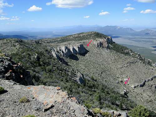
Route up west face that avoids the cliffs
To quote Eric Kassan (peakbagger trip report):
"This peak had quite a variety- route-finding through thick forest, route-finding to find a good route to the summit (there is no trail), loose rocky terrain, bushwhacking, crossing steep loose terrain, a little rock scrambling (class 3, though one could find and do tougher), and avoiding cliffs."
He pretty well summed up the route but to clarify it a bit, head up toward the west cliffs, working your way to the right side using some horse trails and aim for the open slope area which avoids going up through the cliffs as many have done. It is a bit easier way to the summit tableland but adds a bit of additional hiking once up there but well worth the extra effort.
Overall elevation gain from where we parked was about 2200' and five miles round trip. It does get very steep in places but you can avoid the cliffs and the steep chutes if you find the correct way up.
 Heading for the drainage
|  The gully on way up
|  Key slope to plateau
|
 Avoid the cliffs
|  Heading for the summit
|  Dutch John summit
|
Red Tape

Benchmark
When to Climb
This mountain is probably climbable in any season although in high snow years (fairly rare), you'd be best served to wait until the snow is gone as there are some very steep slopes to deal with. Summer can be very hot so if you attempt it in summer, carry a lot of water and watch for snakes. Spring is tick season so check yourself after dealing with this mountain in the springtime. This is wild horse country and ticks and wild horses go together in Nevada so be aware.SUMMIT VIEWS
 Looking west
|  Looking east
|  Looking north
|
Camping
We car camped at the large camp spot just up the road from Muleshoe Well. There were a lot of places you could camp but remember to pack out all your trash and leave the area in as good a condition as you found it. There is no water available in this desert environment so have plenty.
Weather
Pioche
Summit visitors
This isn't a mountain that many have climbed but a register placed in 1999 has been signed by the following:1999 - Gordon MacLeod,Barbara Lilley & Bill Sanders(they placed the register)
2002 - John Vitz (Calif)
2009 - Ken Jones (Washington)
2009 - Eric Kassan (Nevada)
2009 - Eli Hermansen (Utah)
2012 - Greg Jagielski (Utah)
2012 - Dennis Poulin (Ore) & Victor Zhou (Utah)
2013 - Adam Helman, Bob Packard and Richard Carey
2014 - Dean Molen and Dennis Poulin (2nd visit)
Interestingly enough, as you can see, most of the climbs of this occurred in 2009 and later. Only 4 people had ascended it up until Ken Jones made his visit. Ken mentioned that when he climbed it, he had snow to contend with and it made it a bit dicey in a couple of spots and that was in June. He didn't expect the snow that late in the season so sometimes you get surprises with Nevada mountains.

| 
| 
|