
|
|
Mountain/Rock |
|---|---|
|
|
38.93200°N / 114.8937°W |
|
|
White Pine |
|
|
Hiking |
|
|
Spring, Summer, Fall |
|
|
10120 ft / 3085 m |
|
|
Overview
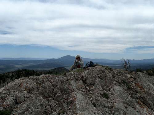
Dennis on the summit
This is a nice mountain that sees few visitors, very few indeed since it is overshadowed by the more visible and more frequented Ward Mountain to the north. The summit register was placed in 2003 and since then, only 4 others had signed it. Its worth sharing that Gordon MacLeod and Barbara Lilley placed the register in on June 9th of 2003 and the next visitor was John Vitz on June 21st 2003. After that, no one signed in until Brad Boester did in July of 2010, a full 7 Years. Then in 2012 Greg Jagielski hit the summit, making a route up the west side via Cottonwood Canyon. I had planned to accompany Greg on that visit but the weather was threatening and I was still tired from our ascent of Major-Schell mountain the day before. Greg can move at hyper speed while I do turtle speed so he managed to get up and down before the snow storm hit. Then Ken Jones hit the summit on May 29th of 2013 and Dennis Poulin and I followed his footsteps two weeks later on June 15th. That's it, since 2003, only 7 of us have signed that register. I've put pics of all the register pages in the pic section at the left. I'm hopeful this summitpost page might help others to find their way to the top and I'd appreciate it if those who use this information would sign the summitpost register here and contribute some pictures from their visit.
I haven't been able to find any information about the history of this mountain nor about mining activities that probably occurred nearby. One nice aspect of this mountain is its elevation, over ten thousand feet high and someday I would actively like to visit the summits of as many ten thousand foot high mountains in Nevada as I am able to. We did see several elk on our visit but lower down it appears that cattle are grazed in the area.
With a prominence of just over 2000', it comes in at the 162nd mountain with prominence in the State of Nevada. Just south of Ely, it could be combined with a visit to Ward Mountain and Major-Schell Mountain if you are interested in picking up nearby prominence peaks.
 Heading for the mountain Heading for the mountain |  Up there is the summit Up there is the summit |  Nearing the ridgeline on SW side Nearing the ridgeline on SW side |
Getting There
There are several possible ways that you could access this mountain but what worked for us was a route that Ken Jones kindly posted on peakbagger shortly before our visit to the mountain. Since I know this route works, I'll share it here. From Ely, we followed his fine directions and they worked great for us. This is what Ken had to say:"About 15.5 miles south of where Hwys 6 and 93 split in south Ely, at about virtual milepost 54.8 on US 6/50/93, find a road heading south-southwest. It goes by a Nevada Division of Forestry facility and a state prison early on. Zero your odometer at the highway, and proceed as follows (this drive requires high clearance and 4WD, at least when I was there):
0.0 Leave highway and pavement
4.0 Pass signed junction to the Horse and Cow Camp Loop, continue straight
5.7 Keep to the right and cross a cattle guard
8.1 Reach a T junction and turn left (south)
9.4 Turn right onto a lesser road, signed "White Rock" - high clearance advised
10.9 A mapped lesser road goes left, but keep right on better road
11.7 Keep right
11.8 Cross cattle guard
11.9 Keep left at fork
13.0 Reach South White Rock Spring - road has mud hole, and I crossed just downhill from road; road gets even rougher and I needed 4WD
14.3 Spur goes right, stay left/straight
14.5 Skip another spur to the right
15.2 Pass Summit Spring, continue straight
15.4 Reach saddle, go left on grassy track
15.6 I parked here in a clearing; in less muddy conditions you may be able to drive (with HC 4WD) along my GPS track to just below 9600'"
Ken's directions were really helpful and while the road was rough and required high clearance and even 4WD in a few spots, we were able to get further along the jeep track than he'd been able to go as we had few issues with wet or muddy spots. We could have actually taken the road all the way to its end but decided to park and walk it after reducing the distance and elevation gain by another 200 feet and probably about 1/2 mile.
Western Approach:
 Summit area Summit area |  Summit Benchmark Summit Benchmark |  Register Register |
Route
We followed Ken's directions to Summit Spring and found a rough 4WD track that headed west and upward. We followed that track to about the 9400' level and parked in a nice open area. Then we walked up the track to its end at 9600' and went cross country from there. Ken has posted a nice GPS track at peakbagger and I recommend that to you as it worked great for us. The end result was an easy hike of less than 800 feet and about a mile and a half each way. We had the summit's highest point waypointed and just worked our way up towards it.Getting over on the west side of the mountain enabled us to find a relatively easy way up through some ledges and rocks to the summit. Once on the rocky spine of the summit ridge, it was just a matter of merely finding our way over the highest spot where a benchmark, cairn and glass jar register bottle were located. The views were exceptional in all directions and worth the effort. Our descent was made interesting when we found a huge and deep hole in the ground that you wouldn't want to fall into. It would be tough to get out of and gave me the shivers thinking of descending the mountainside in the dark. As we got back closer to our vehicle, we saw two very fine elk walking the slope below us. They are beautiful animals and always a thrill to see while you are hiking.
Worth noting: It did look feasible on the map that Summit Spring might be also accessible via the road that comes from the Ward Charcoal ovens or up via Williams Creek, aiming for the Mahogany Hotel Springs area. You might want to check your maps for more enlightenment but if that worked, it would be a shorter way. If you try this way and it works out for you, please let me know so it can be added to this page.
I also noted that in an article posted by Joel Brewster in the Ascender may have attempted either the Ward Charcoal Kiln road or the Williams Creek road by this statement he made after he and Eric Kassan had ascended Ward Mountain: "We had plans of possibly hitting another peak on the way home, but after going partway up the long road to Egan Benchmark, the road soon became very rocky, rutted, and muddy as a stream was running down the middle of the road." Joel or Eric, if you read this, perhaps you could enlighten us with what road you guys tried.
Eric Kassan responded after his visit: "Anji and I tried driving out that way (via Mahogany Hotel Spring and Williams Creek), and it worked out very well- the road was slightly better that the one going south from the pass, though much longer, but much more scenic. Once in the Williams Creek drainage, we stayed on the most direct road back to Cave Valley Road. It looked vaguely familiar, so I'm pretty sure that is what Joel and I had tried before, but at a time when it was too wet."
 Looking NE towards Ely Looking NE towards Ely |  Northward towards Ward Mountain Northward towards Ward Mountain |  Hole in the ground Hole in the ground |
Western Approach via Sawmill Canyon

Cottonwood Canyon approach
Greg Jagielski had success from the west, via the town of Lund and then getting into Sawmill Canyon. I've attached a map he sent me of his route and that will give you an idea of how he did it. As you can see below, John Vitz also went up Sawmill canyon and followed a route up similar to Greg's.
Sawmill Canyon route by John Vitz. John provided me with this information so he approached the summit a different way:
" From the north side of Lund, wander around until you get on the Sawmill Canyon Road, which is pretty good into the canyon. Follow it as it get steep and brushy to where it turns south. I believe that I hiked up the western of the two ridges that lead to Point 9571. I don't remember any problems."
Red Tape
None that I am aware of. We saw no negative signage or indications that the road we used was closed to the public. I believe the mountain is located on BLM land but more information could be found at the BLM office in Ely.
Looking to the east
When to Climb
It is possible to climb this mountain in all seasons, depending on whether the snow pack is problematic for the access road. Greg Jagielski climbed it in mid January from the western side which probably was the best way to access it at that time of year but we accessed it in mid June although a good rainstorm could make the roads we used impassable. Evaluate accordingly, weather is the key on a ten thousand foot high mountain.
Click for weather forecast

Click for weather forecast
Camping
You could car camp just about anywhere but there are also some nice motels in nearby Ely.Visitors to the summit
While this peak is not often climbed, peakbagger has a listing of many of those who have visited. Click here for that information. You can also add Greg Jagielski, Barbara Lilley to the list.  Page 2 of the register
|  Page 3
|  Page 4.
|