Introduction
Every year I look forward with great anticipation to my annual Sierra trip. I used to live in the SF Bay Area and could sneak away to the mountains whenever I wanted. However I moved away a few years ago, and with limited vacation time I’m rarely able to visit the Sierra more than once per year now.
This year was particularly special. This year marked my 20th consecutive year of hiking and climbing in the Sierra Nevada with my good friend MarkZ, who introduced me to this beautiful range. This trip was a commemoration of our friendship and shared love of the mountains - a celebratory trip. We planned to travel 60+ miles from
Leavitt Meadows (Hwy 108) to Toulumne Meadows (Hwy 120) through the proposed addition to the Hoover Wilderness Area and the northern half of Yosemite National Park, exploring the Pacific Crest Trail for most of the way. To cap off our 20-year hike, we spent the last night at the beautiful Ahwahnee Lodge in Yosemite Valley.
Rob and Tom joined the trek this year, Mark’s 2 young cousins from the UK. None of my fellow team members are climbers per se, however I had my heart set on climbing 5 peaks during the 10-day hike.
Day 1: Horse in to Dorothy Lake (15 miles)
![Campsite at Dorothy Lake]() Campsite at Dorothy Lake
Campsite at Dorothy LakeMark and I had already hiked the entire West Walker River trail in both directions and had no desire to do it again. So we began our journey by packing in to Dorothy Lake on horse back with our 2 British companions. The 5-hour horse trip was painful as always but it got us to our destination twice as fast as it would have taken us to hike in with heavy packs.
No sooner had we gotten the tents set up but the weather turned blustery, with a few snow flurries and wind strong enough to cut right through you. Rob and Tom weren’t expecting that and seemed a bit shell shocked. Wide eyed, they started asking questions like, “Is it going to be like this every day?”, and “What is the fastest way out of here?” Chuckling to ourselves, Mark and I explained that there was no "quick way out". Fortunately, we were all dressed adequately enough for the weather and it did not get any worse than that.
(Topo Map)Day 2: Hike to Wilma Lake (7.7 miles) + Keyes Peak
![Keyes Peak]() Keyes Peak
Keyes Peak![SW Ridge of Keyes Peak]() Looking down on the SW Ridge
Looking down on the SW RidgeWith overnight temperatures just below freezing, breaking camp the next morning was a slow process. As the sun cleared the nearby ridge, the warmth of its rays invigorated us and we were soon on our way. Our destination this day was Wilma Lake, though I wanted to climb
Keyes Peak on the way.
About a mile from Dorothy Lake I bid farewell to the other guys, dropped my heavy pack, and broke off from the PCT to do my climb. The peak is about a mile and half off of the PCT through lovely Grace Meadow. I enjoyed both the climb and the time alone to reflect. The route is a very enjoyable Class 2/3 scramble, with little or no steep scree to navigate. The only notable event of the climb was a slight mishap I had while maneuvering up a small (4 ft) granite ledge. I stepped on what appeared to be a solid piece of trunk from a White Bark Pine shrub to gain the ledge, and ended up air-borne landing flat on my back when the wood cracked. Fortunately I suffered no major damage. (That’s my second misstep in as many trips, me, a guy who never trips or falls. I hope this isn’t a trend…) The climb took about 5 hours, after which I still had 6.5 miles to hike to my destination, with a full pack. I rolled into camp after dark at about 8pm, pleased with having gotten the first peak accomplished.
(Topo Map)Day 3: Hike to Kerrick Canyon (6.5 miles)
The following day’s hike took us up and over Bailey Ridge, across Tilden Canyon, and over Macomb Ridge to our next camp at Kerrick Canyon. This is beautiful country and it was a “rest day” for me in that there were no peaks to climb. Mark and I took as much weight as we could from the younger guys who were unaccustomed to carrying heavy multi-day packs.
(Topo Map)
Day 4: Hike to Benson Lake (6 miles)
I broke camp ahead of everyone else on Day 4 because I wanted to climb
Piute Mountain on the way to Benson Lake. The route from Seavey Pass was supposed to be an enjoyable but long Class 3 scramble. Since I was in the midst of moving from one camp to another, I opted for the shorter alternative described as a “broad grass/talus SE chute” to a notch along the NE Ridge. I’ve climbed my share of grassy/talus slopes over the years, however, when I arrived at the spot something about the route just didn’t appeal to me and I decided to skip the climb. Disappointed, I continued on to Benson Lake and made camp. The others arrived a little while later and we all settled into our new home.
After dinner, we began telling stories about past trips and experiences. I mentioned to Rob and Tom that I had a pretty high success rate in calling owls. They pretty much said, “Yeah, prove it”. So I demonstrated my owl call for them, “Hoo-hoohoo-hoo-hoo”. They reacted as expected, like I was insane. Low and behold a few seconds later I heard a response, far away and barely audible. I told them such and they really thought I had lost it. So I let out another hoot. A minute later the owl hooted again. This time it was clearly heard coming from the west shore of Benson Lake. I let out another call, and the owl soon responded from the
east side of Benson Lake. (Now the guys are becoming quite fascinated.)
![SW Ridge of Volunteer Peak]() Volunteer Peak
Volunteer PeakI called again and moments later the owl responded from a tree 50 feet from camp. I responded in turn and the owl flew into the tree directly above our campsite. By now it’s quite dark and time for bed. I discontinued my owl calls, however like all of my past experiences, it continued to hoot in the tree above us for at least an hour, determined to find the intruder (or mate?). Each time the owl hooted, my 2 British friends laughed uncontrollably. Sometime during the course of all of this, we had 2 Screech Owls visit us as well. Anyone hearing this surely must have thought this was the most bizarre night they had ever experienced in the wilderness, with “4” owls unrelentlessly hooting and screeching half the night.
(Topo Map)
Day 5: Hike to Smedberg Lake (4 miles) + Volunteer Peak
![Volunteer Peak, North Face]() Volunteer Peak
Volunteer Peak![Smedberg Lake]() Smedberg Lake
Smedberg LakeI again broke camp early the next day with the intention of climbing
Volunteer Peak on my way to
Smedberg Lake. I was feeling particularly strong, inspired by the interaction with the owls no doubt, and practically sprinted the 2 miles and 2,000’ elevation gain to the west side of Volunteer Peak. I dropped my pack and left a marker so that Mark could see where I departed the trail to begin my climb. An hour later, I was standing atop Volunteer Peak. The SW Ridge is an exceptionally enjoyable Class 2/3 climb on nice rock nearly the whole way. The skies were clear and the weather perfect for climbing. I was in heaven! That evening we enjoyed a spectacular sunset at Smedberg Lake.
(Topo Map)Day 6: Hike to Miller Lake (8 miles)
We had a long tough hike to Miller Lake the next day, up and over Benson Pass, across Matterhorn Canyon and the final steep climb up to Miller Lake. We nearly didn’t make it with the relatively heavy packs we were carrying. Tomorrow would be a much needed rest day for the group.
(Topo Map)
Day 7: Climb Whorl Mountain (12 miles RT)
![Whorl Mountain]() Whorl Mountain
Whorl Mountain![Secor s Chute on Whorl Mtn]() Secor's Chute
Secor's Chute![Sandy Walkway on Whorl Mtn]() Sandy Walkway
Sandy WalkwayDay 7 was a scheduled rest day; however I had slightly higher ambitions. For me, this was the highlight of the trip. I was to climb
Whorl Mountain, a peak that I had wanted to climb for years. I left camp at 7:45am, hiking 2 miles down the PCT before heading off-trail for 4 miles through Spiller Canyon. The weather was again perfect and the hike through Spiller Canyon quite beautiful. Most of the hiking was easy, but there were several places where hundreds of trees had fallen leaving quite the obstacle to navigate. It took me 3 hours to reach the SE side of the mountain. I was right on schedule! I stopped for 20 minutes to change into my rock boots and grab a snack. I did the same thing after finishing the climb. This would prove to be the only 2 times that I would sit down for more than a minute the entire day.
The normal route to the summit follows 3 chutes. You start up the leftmost chute, transition to the middle chute and ascend a bit higher, then transition to the rightmost chute to a large chockstone.
I started up directly below the point where I thought the leftmost chute began. I was well below the normal approach, a bench that traverses the peak from Horse Creek Pass to the north, and I had to negotiate more sand and scree than I anticipated on the lower part of the climb. I found the
leftmost chute based on the SP photos that I had seen and small cairns that someone had left. I made my way up the chute until I was pretty high and the chute started to disappear. There was supposed to be a ledge on the right leading to the middle chute, but I didn’t see it. In fact, everything to the right seemed very steep to me, and the route was forcing me further left than I expected. After a few Class 4 moves, I ultimately ended up way off to the left in a very broad chute. I knew I was off route but didn’t see an alternative. So I followed the chute as high as it would take me.
When I reached the ridgeline, I could see the
sandy walkway on the west side of the crest that leads to the summit, but it was well to the north of my position and impossible to reach unprotected. The ridge top also required exposed technical climbing, so that wasn’t an option. The best that I could do at this point was to make my way along the west side of the crest as far as I could go, then traverse back to the east side of the ridge to try to get back on route. I made it back over the ridge, which required a few short/easy but exposed Class 5 moves. I continued to make my way northwards on the east side of the ridge and finally found what appeared to be one of the chutes described in the route description. I climbed toward what I thought was the
chockstone only it was 5 times bigger than I anticipated. As I gazed into what appeared to be a dead end cave, I was convinced that I was still off route and decided to give up. I actually said out loud, “Damn it. This mountain beat me.” At 3pm, I didn’t have any more time to spend route finding. As I turned around to descend and head back to camp, I recognized the image of a picture posted on SP
looking down from the chockstone. I knew instantly that I was in fact on route. So I turned back around and figured out that the cave was not a dead end, but that there was a vertical opening inside of it that lead up through the chockstone. Elated that I had solved the puzzle, I made my way up through the chockstone, found the sandy walkway that cleaves the ridgeline, and dashed up to the summit.
![Sawtooth Ridge / Matterhorn Pk]() Sawtooth Ridge from Whorl Mtn
Sawtooth Ridge from Whorl Mtn
By now, it’s 3:20pm and I still have to descend from the peak and hike the 6 miles back to camp. I stayed all of 10 minutes to sign the register and snap a few photos, and then made my way uneventfully back down the mountain. Unfortunately, in my haste I left my sunglasses on the summit… I finally rolled back into camp at 7:30pm, nearly 12 hours after I had left, exhausted yet thrilled with having successfully climbed Whorl Mountain.
(Topo Map)
Day 8: Hike to Virginia Canyon (3.5 miles)
The next day was the easiest of the whole trip. Our packs were now getting a bit lighter and we only had 3.5 miles to travel. We moved our camp to a scenic spot where the PCT crosses Virginia Canyon.
(Topo Map)
Day 9: Hike to Glen Aulin (7.5 miles) + Pluto Dome
![Pluto Dome]() Pluto Dome
Pluto DomeThe hike to Glen Aulin through Cold Canyon on Day 9 was beautiful, but long and dry. As expected, we didn’t find any water after leaving Virginia Canyon. We made good time though, covering the distance in about 4 hours.
After setting up camp, I did an unexpected climb of
Pluto Dome, which is a granitoid dome that overlooks the Grand Canyon of the Toulumne. I started out just taking a short stroll and the next thing I knew I was standing on top of this very scenic peak… We spent the rest of the evening talking about our trip over a roaring campfire.
(Topo Map)
Day 10: Hike to Toulumne Meadows (6 miles) + Lembert Dome
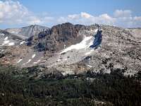
![Unicorn and Cathedral Peaks]() Cathedral and Unicorn Peaks
Cathedral and Unicorn PeaksAlas, our trip was coming to an end. We hiked the final 6 miles of our journey under beautiful clear skies. What a magnificent part of Yosemite to conclude our adventure, through the ever tranquil Toulumne Meadows with Cathedral and Unicorn Peaks beckoning to us in the distance.
It seems that Mark and his wife had schemed up quite a celebration for us. Upon reaching the trailhead, we were greeted by various family members and friends waiting with an amazing picnic for us! I had planned to finish our trip with a quick ascent of
Lembert Dome, but lost all interest with it as soon as I saw the feast they had prepared. Wouldn’t you know it, now of all times, Tom wants to go climbing! As he had never climbed anything before, I felt compelled to go with him on his quest to climb Lembert Dome. We virtually sprinted up to the summit and back, making the round trip in just over an hour, leaving us with plenty of time to assault the wonderful lunch that had been prepared for us before we had to disband.
(Topo Map)
The Final Celebration
Later that evening, the 13 people in our extended group reserved the “Captain’s Table” in the Ahwahnee restaurant. We had an incredible dinner! Red wine never tasted so good! It was a very memorable way to celebrate a life-long friendship and 20-years of awesome trips to the Sierra Nevada.
Norman Maclean once said, “Eventually, all things merge into one, and a river runs through it.”
He could just as easily have been speaking about a mountain range.


Comments
Post a Comment