An Unexpected Party
Although I have summited many peaks during the past few years, I had not considered myself a mountaineer. However, my love of mountains has been firm. Several months ago, I was researching various peaks to possibly climb in the United States. While doing so, I met a man named Jack online who had an interest in climbing one particular peak that I was also interested in climbing. It was not Gannett Peak. However, after we started exchanging notes, we discovered we were both State Highpointers and and both still had Gannett Peak on our respective “to do” lists. Gannett Peak is not a mountain to take lightly. Widely considered the second-most difficult State Highpoint to summit, the peak requires a combination of courage, skill, endurance, and determination for a successful climb. As Jack and I began discussing the possibility of climbing Gannett Peak, we started to believe that we each had attributes to form a formidable climbing duo. A plan was soon set into motion. Gannett Peak became our new target.
On the Doorstep
We spent the next few months planning our trip. The first major decision was which route to choose. One possibility was to pay the Wind River Reservation for passage through Ink Wells, but that would cost each of us a lot of extra money so we immediately discarded that option. That left us with two main possibilities: A western approach and an eastern approach. The standard route for the peak is via the western approach; a grueling 40-mile roundtrip hike and climb. Conversely, the eastern approach via the Glacier Trail is longer… 50 miles roundtrip… but has a shorter, less technical summit day and, hence, a stronger chance for a successful summit attempt. When Jack and I realized the eastern approach was only five extra miles each direction when compared to the western approach, but with a higher chance of success for summit day, the option for us was a no-brainer.
The second major decision was which timeframe to plan our trip. We knew we wanted to attempt Gannett Peak while much snow was still present on the mountain, and potentially while a snowbridge is present over the mountain’s infamous and dangerous bergschrund. However, we did not want to slog through 25 miles of deep snow to get to the summit. One distinct advantage of the eastern approach is a potentially earlier climbing season for Gannett Peak, as much of the Glacier Trail tends to melt out sooner than the western approach for the mountain. After reading multiple trip reports and discussing options with successful Gannett Peak summiters from the past few years, we chose late June for our climbing trip. Initially, this appeared to be a good plan. During late April, the temperatures in the region were unusually warm and a late June climb appeared ideal. However, unusual late Spring snowstorms struck the region from May to early June, dumping a lot of snowpack in the Wind River Range later during the year than normal. The late Spring snowpack was not melting away quickly, either, and only several days prior to our original planned start date we postponed our trip by three weeks, to mid-July.
A Warm Welcome
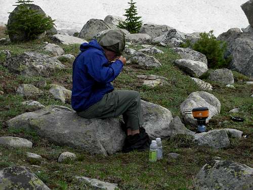
With Jack living in Pennsylvania and me living in Washington, either we could both take flights and then use a rental car for driving to/from the trailhead, or I could drive the nearly 1000 miles from my home and pick-up Jack at a major city somewhere along the way. I chose the latter option, as I did not mind driving long distances… most of my State Highpointing trips involved long drives… and the cost would be significantly cheaper. I picked up Jack at the Gallatin Airport in Bozeman, Montana, on Wednesday, July 8, and then we headed south together to Dubois, Wyoming. Jack had made hotel reservations for us in Dubois, and both our drive together and dinner that night gave us a lot of time to become properly acquainted in-person. I immediately liked him. He had the positive attitude and determination necessary for the intense trip that would begin for us the next morning.
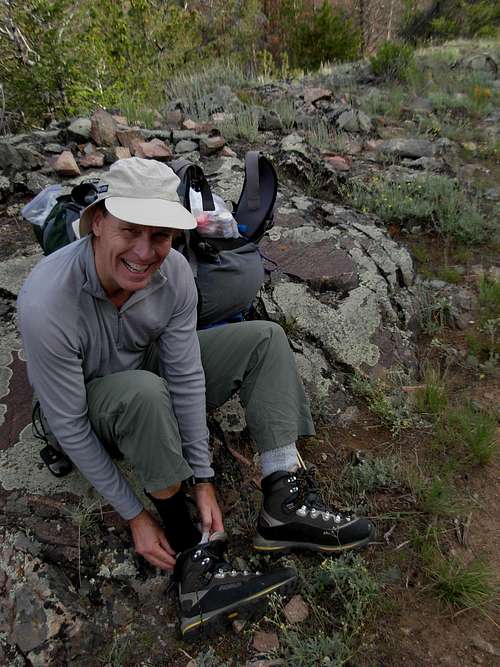
![Gannett Peak Trip - Good Spirits]() Posing At Trailhead
Posing At Trailhead
When we woke up early the next day (July 9), we each shaved one last time, pledging not to shave during our entire trip. This was an amibitious goal for me, as I had never gone more than 3-4 days without shaving since hair first started growing on my face. We arrived at the trailhead by 6:15 AM, heading out on the Glacier Trail at 6:40 AM. It was later than I would have preferred starting, but it was only the first day of hiking and we had plenty of daylight to work with. We took a pre-hike photo at the trailhead sign and we were ready for our adventure to begin.
Over Hill and Under Hill
![Gannett Peak Trip - Enjoying Scenery]() Enjoying The Early Scenery Along Trail
Enjoying The Early Scenery Along Trail
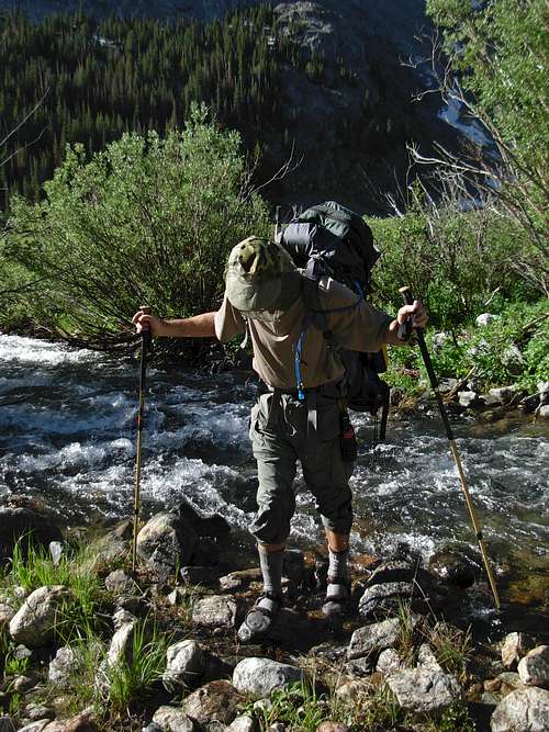
Make no mistake about it: Although the Glacier Trail is a very heavily used route, the condition of the trail is rough, rugged, and does not waste any time before encountering multiple types of terrain. When we crossed Torrey Creek early during our hike, it was a real revelation for each of us. The swiftness and depth of the creek made us a little nervous about the multiple creeks we would need to ford the following day. Fortunately, Torrey Creek has a well-constructed bridge and no ford was required.
![Gannett Peak Trip - Warning Signs]() Blisters Starting Already???
Blisters Starting Already???
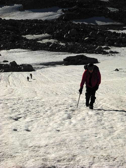
Within the first three miles, Jack had to stop because he felt a blister forming on one of his heels. I was very alarmed by this, as it seemed too early for blisters to start forming during what would become a long hike. Sparking my curiosity, I asked Jack how many times he had used his mountaineering boots. He told me “Five times, including on Wheeler Peak in New Mexico last month.” I knew Wheeler Peak was no Gannett Peak, and we would make multiple stops because of Jack’s blister pains, but I kept silent about the blister situation and tried to maintain a positive attitude. After passing Bomber Basin, the trail climbed approximately 30 switchbacks uphill before reaching open areas north of Arrow Pass at 10,000’ elevation. Although Arrow Pass always appeared close as we approached that location, it was almost de-moralizing how far away the high point of our first day truly was, due to the vast tree-less slopes and no visual gauges for distances. We arrived at Arrow Pass (10,895’ elevation) by 1:30 PM. One personal thing I realized which I had never noticed prior to this trip is that I actually seemed to be breathing easier above 10,000’ elevation than below it. Jack was shocked at how far I was able to travel with little food and water, despite having an ample supply. It was as if my body was adapting to the environment, which could either be attributed to genetics or training.
![Gannett Peak Trip - Arrow Pass]() Resting At Arrow Pass
Resting At Arrow Pass
We reached Double Lake, the second of four lakes along the Glacier Trail, by 4:15 PM. Jack wanted to stop and setup camp. This took me totally off-guard, as we still had over four hours remaining before sunset, were only slightly more than one mile away from the next lake, and were only halfway (11 miles) to our intended high camp with another tough day of hiking ahead of us. I had never stopped to setup a campsite so early in the day during a backpacking trip, and I thought it was the wrong decision to make. However, considering Jack’s limited exposure to high altitude and the onset of his heel blisters, I agreed with Jack’s decision and I found a nice campsite nicely situated along the lakeshore. I hoped with a good night’s rest, we would be ready for the long hike to the high camp the following day.
![Gannett Peak Trip - Double Lake Crossing]() Fording Outlet Of Double Lake
Fording Outlet Of Double Lake
The mosquitoes at the lake were HORRIBLE. They would swarm us at all times except when the wind was briskly blowing. They were especially aggressive while we were using my Jetboil cooking system to make our meals, attracted to the heat of the system. In regards to meals, several previous summiters recommended stashing a small cache of food at the first night’s campsite, wherever it might be, to lose a little pack weight for the ascent while at the same time saving food for the last day of the descent. Finding a proper, potentially bearproof, location, we stashed some food and marked the site with a cairn.
Fire and Water
![Gannett Peak Trip - Double Lake]() Double Lake
Double Lake
The next day, July 10, we woke up and began hiking by 7:00 AM. I wanted to start earlier, but that was out of my control. A group of four climbers (Steven, Rich, Ed, Tom) had camped near our site. We already knew about this particular group and had prior correspondence with them prior to the trip. In fact, Steven, the organizer of the group, even had made multiple attempts to convince Jack and I to join their party because of a similar trip plan and summit day. However, considering Steven had several different hiking objectives and planned for a high camp at a lower elevation than we did, Jack and I opted to keep the two parties separate while at the same time agreeing to potentially team together if both groups were attempting to summit Gannett Peak at the same time.
![Gannett Peak Trip - Star Lake]() Star Lake
Star Lake
Jack could still feel blisters, by this stage on both heels. His pace was progressively slowing during the day. After reaching a high point of 10,350’ elevation shortly after Star Lake, the trail switchbacked downhill and became more gentle-sloped for much of the remainder of the day. This is not to suggest the route became easier, as the various terrains encountered (rocky slopes, exposed tree roots, mudholes, stream crossings) made for some interesting moments. Also, Dinwoody Creek intimidated us a bit as we hoped we would not need to ford such a monster drainage further upstream.
![Gannett Peak Trip - Ink Wells Junction]() Ink Wells Junction
Ink Wells Junction
Shortly after passing the Ink Wells Junction (approximately 18.5 miles from the trailhead) at 1:40 PM, we finally caught our first glimpses of Gannett Peak. Around this time, we encountered several interesting people. First, a couple from Lake Stevens, Washington, coincidentally one of the closest cities to my home, was heading back towards the trailhead because they felt the Gannett Creek crossing several miles away was too dangerous. This had us very concerned, and we envisioned the rough waters of Torrey Creek and Dinwoody Creek that we had seen earlier. Second, we encountered a USFS worker (“Maddy”) monitoring the trail conditions. Unlike the couple from Washington, she did not anticipate any major problems crossing the streams further up the trail, although she was quick to point out she had yet to see them herself. However, she added that multiple parties had successfully summited Gannett Peak during the past week. Third, and most importantly, we encountered a group of six people from Colorado who had just summited Gannett Peak the previous day. They told us the creek crossings were manageable, the route up the mountain was well-defined from summiters the previous days, and that roping up was not necessary (and most likely not advised). However, what we also learned from these people, and other people we encountered on the trail, was that a storm system was supposed to hit the Gannett Peak area starting the following afternoon and possibly last for several days. This meant our best chance to summit would need to be the following morning, which also meant we had to reach as high of a high camp elevation as possible this day.
![Gannett Peak Trip - First View Of Goal]() Our First View Of Gannett Peak
Our First View Of Gannett Peak
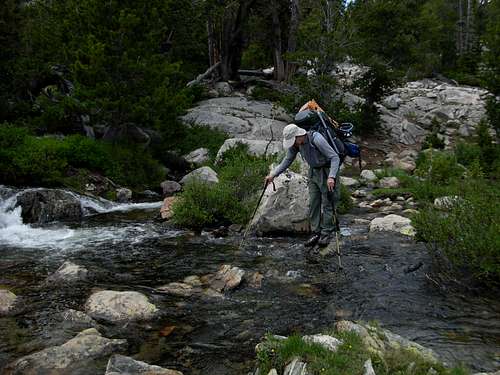
We continued on the trail and had many creeks to cross. Most of the creek crossings were minor, but eventually we had two major creek crossings to ford: Klondike Creek and Gannett Creek. For Klondike Creek, we each removed our boots and socks, and wore sandals (or in Jack’s case, flip-flops) for the ford. For Gannett Creek, which was the last major creek crossing for the ascent, we did the same. However, the water of that creek was so icy-cold that I was almost screaming as I ran onto the embankment on the other side. With all major trail obstacles now behind us, we proceeded to a high camp at approximately 10,400’ elevation, arriving by 7:00 PM. This was a lower elevation high camp than we originally intended, but Jack said he could not continue walking with his blisters aching and the hiking day was already longer than he would ever normally do.
![Gannett Peak Trip - Gannett Creek Crossing]() Fording Gannett Creek
Fording Gannett Creek
Similar to our campsite the previous evening, the mosquitoes at our high camp were horrible. As annoying as they were, Jack was surprised to hear me suggest the bugs on the Glacier Trail were not as annoying or plentiful as the ones I encountered at Eagle Mountain (Minnesota’s State Highpoint) during the previous Summer. It had been a long day, and soon after setting up camp and having dinner, we got ready to sleep. Jack, thinking about his blisters, believed a rest day the following day might be the best option. However, with reports that a storm system might be moving in the following afternoon that could last several days, we determined that the next day was our best chance for a successful summit attempt. Plus, it was unlikely during one “rest day” that the blisters would totally go away. Jack asked me, “Then are you prepared to drag my butt up that mountain tomorrow?” I wholeheartedly agreed, and our summit plans remained intact. However, our original plans intended for a early (2:00-3:00 AM) start time, and I suggested leaving a little later to give Jack more time to rest during the night.
Out of the Frying-Pan into the Fire
At 3:00 AM, we heard people walking by our tent. Steven called out to us, and told Jack and I that we really needed to start our summit attempt soon, to ensure we could reach the summit prior to midday storms and sun-softened snowy slopes. He also briefly mentioned that one of his partners got altitude sickness the prior day, which is the reason they had not camped further up the mountain. He then continued his ascent as we continued lying in our sleeping bags. Jack and I began getting prepared, he had breakfast (while I had a small snack), and we began our ascent up the trail at 4:15 AM.
The Glacier Trail actually continued beyond our high camp for another 1-2 miles, but much of that stretch was covered by snow and difficult to locate. In addition, the boot tracks from the previous days had been mostly melted by the previous day’s heat. We were slightly delayed by repeatedly stopping to make certain we were heading the correct direction. Eventually, I pointed out to Jack that I could see two headlamps in the distance ahead of us. We knew it was Steven’s group, but it appeared the headlamps were not moving much. In fact, we were gaining ground on them. By 5:15 AM, we reached Steven and Rich, sitting next to some large boulders. Ed and Tom had not made the ascent, as Ed caught altitude sickness and decided to turn around. For someone who had been so ademate about leaving early, I was shocked to see Steven not ascending. He told us he was waiting for the sun to rise and provide enough light to traverse over the boulder field ahead of them, near the base of the mountain. He was afraid of falling into a snow-covered rock-well in the darkness, which seemed odd to me considering the top ridge of the boulder field (where the “trail” was located) was not snow-covered and we were all wearing headlamps. Considering Steven had been the Gannett Peak twice before, his partner Rich did not seem to question Steven’s logic or familiarity with the route. As light began to fill the valley, the four of us headed towards and across the boulder field together. It was during this time that Jack and I learned that Rich was an inexperienced climber, and this was his firstever time wearing and using crampons. I felt that was very irresponsible of Steven to include an inexperienced crampon user on one of the most dangerous State Highpoints in the country. Ironically, it was Rich, not Steven, who was in good spirits, seemed to have a lot of energy, and seemed to a quick study. I instantly liked Rich, and his humor kept all of our spirits high during the climb.
![Gannett Peak Trip - Ascent]() Ascending Lower Slopes Of Gannett Peak
Ascending Lower Slopes Of Gannett Peak
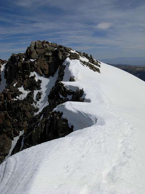
By the time we reached the base of the mountain, Steven had pointed out the intended summit route for me. What seemed odd to me was I did not find any traces of tracks from previous summiters via Steven’s route. However, upon examining the upper slopes, it appeared we could see boot paths leading up the mountain. Given the fact that Rich was inexperienced, and Steven and Jack were both walking slowly up the slopes, I took the initiative to lead the group and break the trail. Jack followed behind me, albeit very slowly, and I would essentially wait for him to catch up before proceeding up each section of the mountain. We looked to our left and could see two climbers returning to Bonney Pass from the summit. After seeing the Bonney Pass route from that perspective, Jack and I knew why so many people turn around on that approach.
![Gannett Peak Trip - Bergschrund]() Bergschrund, With Snowbridge Still Intact...
Bergschrund, With Snowbridge Still Intact...
When I finally arrived at the infamous bergschrund, the snowbridge along the main bootpath routes was still present. However, as I began to cross the bergschrund, part of the snowbridge collapsed. Fortunately, the bergschrund gap was not too substantial, I could reach the other side with my hands and ice axe, and I was prepared for calamities crossing there. None of the reports about the steepness of the slope above the bergschrund really did justice to describe it. This slope is STEEP. Much steeper than any snow/ice slope I had ever previously climbed. Thankfully, the bootpaths leading up the slope gave me a route to follow and I slowly created firm kick-steps during my ascent to assist Jack and the others behind him. When I reached the top of the slope, I sat off to the side near some rocks, to help prevent any accidental slides, waiting for Jack. I watched him cross the bergschrund and slowly begin his ascent of the steep slope. After a while, I walked over to the top of the slope and looked down. Something about Jack’s expressions and movement seemed strange. I called down to him, “Jack! Are you OK?” He looked up at me, paused, and said, “I’m out. Energy depleted.” He then began descending the slope. I made several attempts and offers to go help him off the mountain, essentially ending my summit attempt, to which Jack assured me he would be OK getting down on his own and pressed me to go onward to the summit. In theory, I was beyond the most technical portion of the climb. In reality, if a summit path was not already present, I probably would have turned around, anyway. In addition, Steven and Rich were still ascending a short distance behind us, and had a rope if needed during the descent.
![Gannett Peak Trip - View Above Bergschrund]() Ascending Steep Slope Above Bergschrund
Ascending Steep Slope Above Bergschrund
I have total respect for the decision Jack made. It takes a strong-willed person to go that far, travel across so many obstacles, and come so close to a goal (800’-900’ elevation from the summit, in this case) only to turn around. I have known people who have had broken fingers and toes, or other injuries, and would have continued due to “summit fever”. I am very proud of Jack; he knew his limits that day and made a difficult choice. It is one thing for a person to reach a summit, but it is meaningless if that person cannot return from the summit. During the final slopes and ridge of the mountain, I was able to have a great view of Jack and monitor his progress, which I continually did. As I neared the summit, my own progress was slowed by my constant concern and viewing of Jack. I felt very weird without him being there, as we had planned.
The Gathering of the Clouds
![Gannett Peak Trip - Summit Ridge]() Ascending Summit Ridge Of Gannett Peak
Ascending Summit Ridge Of Gannett Peak
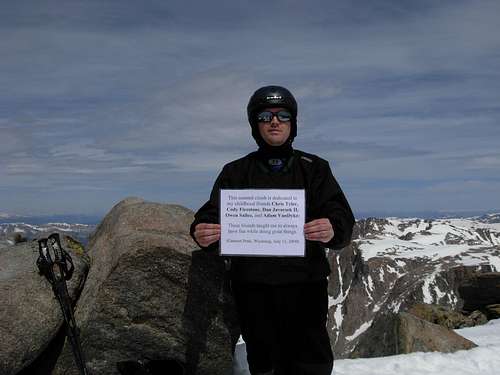
I reached the summit (13,804' elevation) of Gannett Peak, solo, on July 11, 2009 at 11:15 AM. Gannett Peak became my 39th State Highpoint, and in just slightly more than two years time. Having driven nearly 1000 miles, hiked and climbed very rugged terrain for 25 miles, traversing multiple glaciers and boulder fields, and overcoming many other obstacles, this was the most challenging and rewarding mountain summit I had ever attained. However, it felt a little empty being at the summit without my climbing partner with me. The views were spectacular, I was at the highest point in Wyoming, and I knew it was a major accomplishment, but I could not get him out of my mind. Within a few minutes of being at the summit, I turned around and was shocked to be standing face-to-face with another solo climber who I had never seen before. It was as if he arrived via magic, as I never once had seen him approaching. It turns out he took the western approach over Bonney Pass, but crazily (in my opinion) he did not have a helmet, pack, or ice axe with him. He said he had been on the mountain multiple occasions. We spent a few minutes taking photos. I watched the snowy and icy slopes of the mountain below us, and was astonished to watch large crevasses opening up within a ten-minute span. It was both impressive and alarming at the same time, as the snow conditions were obviously becoming sloppy under the hot sun. The other summiter commented that he had never seen such a rapid snowmelt happening. I also noticed that Steven and Rich had turned around and ended their summit attempt, ensuring that I would be descending the mountain solo… not my ideal choice by any means. Now 11:35 AM, it was definitely time to go.
![Gannett Peak Trip - Summit Pose]() Posing At Gannett Peak Summit
Posing At Gannett Peak Summit
I parted ways with the other summiter and began my descent. Although I have confidence in my abilities, I also have the realization of the real dangers on such a technical peak. Although being a solo glacier traveler is not what I wanted to be, and definitely not recommended, by being a soloist I am certain I actually took more time and used more caution than if I had a partner with me. I used multiple ice axe techniques during my descent. I never once glissaded. Instead, I would get low to the slope, facing outward, and use the following technique: Firmly plant ice axe into ground, then left plunge-step, then right plunge-step, then repeat. It was a slow process, but it was fairly safe and quite manageable under the circumstances. With my prior kick-steps already in place on the steep slope located above the bergschrund, I was able to maintain the same descent technique even on that slope, always remaining focused and ready to use self-arrest if needed. When I reached the bergschrund, the snowbridge was completely gone. I had to analyze my options. It was possible I could have skirted horizontally along the bergschrund edge until finding another snow-covered location, but I determined that would take me off-route and might present hidden dangers. Instead, I opted to jump across the bergschrund and be prepared to self-arrest. 1… 2… 3… and then I leaped over five feet, clearing the bergschrund but almost hurting my leg because of the steep angle of the slope. At that point, I breathed a sigh of relief, as I knew the most dangerous section of the route was now behind me.
![Gannett Peak Trip - Descent Route]() Looking At Descent Route From Summit Ridge
Looking At Descent Route From Summit Ridge
Despite the most difficult stretch of the route being behind me, I still used my “firmly plant ice axe into ground, then left plunge-step, then right plunge-step, then repeat” technique during much of the rest of the descent. I still never once glissaded, even when I found glissade tracks left behind by Jack, Steven, and Rich. Plunge-stepping seemed much safer to me (as it usually does), especially while descending solo. By 2:00 PM, I had caught up to, and passed, Steven and Rich. Apparently, it sounded like they turned around because they determined they did not have enough water for the summit climb. By 2:30 PM, I had finally reached Jack, who was now walking at a near snails-pace. He immediately started to say congratulations, to which I interrupted and told him to give me his backpack. I did not want to even talk about the summit. My only concern was for his safety, and I did not want all that extra weight on his already hurting feet, but he refused. I walked with him for a while, and we encountered a trio of USFS workers (“Maddy”, “Monica”, and “Ryan”) approaching us along the Glacier Trail. When Jack told them that he did not think he would be able to walk the remaining 21.5 miles back to the trailhead, they showed little empathy towards the situation and offered little advice. The only piece of advice worth exploring was for Jack to wear sandals during the descent rather than his mountaineering boots. Jack and I continued back to camp. He did not want to stop for first aid before then, so I went ahead to camp to prepare for his arrival.
![Gannett Peak Trip - Raincover Ice Water]() Using A Raincover To Soak Jack's Feet
Using A Raincover To Soak Jack's Feet
The first thing I wanted him to do was to take off his boots and socks, and then soak his blister-burning feet in ice-cold water. With a glacial-fed stream (Dinwoody Creek) nearby, ice-cold water was plentiful but having Jack walk back and forth to that water source was not feasible. The largest water-holding container we had was my Jetboil cooking pot, not enough room for one foot to rest in let alone two feet. I knew I had to think “out of the box”, and I thought about how my backpack’s raincover repels water… so perhaps it would hold water. I ran back and forth to Dinwoody Creek several times, filling up water containers and bringing them back to camp to fill the raincover. The idea actually worked. When Jack arrived back at camp, the plan worked perfectly. He seemed to appreciate the ice-water-in-the-raincover idea, and took advantage of that opportunity several times that afternoon. I loaned Jack my “Teva” sandals, as his flip-flops were not very usable for walking on rough terrain. My sandal size was one full size smaller than his, but I was able to stretch the straps out just enough to barely work for him. I had different forms of medication and bandages available, so we administered first aid to the blisters, which were now blisters-within-blisters and turning black, and Jack slept for several hours in the tent that afternoon. Thinking about how the USFS workers would not help us, I sat down next to Jack in the tent later that evening and stressed the point that, until anything happens to the contrary, we were in the wilderness alone and had to get ourselves out. Basically, we had to mentally put ourselves into survival mode. I proposed multiple options for us, including me taking shifts of carrying his backpack and then running back and getting my backpack, but he kept saying how he would not be able to walk out the remaining 21 miles from our high camp. We ultimately decided to seek out the outfitter that Steven’s group had interacted with, with the hope that he might be able to take him back to the trailhead via horseback, but that would mean Jack would need to walk at least five miles to the outfitter’s location… if we could even find it.
The Clouds Burst
![Gannett Peak Trip - High Camp]() View From High Camp
View From High Camp
The next morning, I made certain Jack’s equipment was all packed before mine and asked him to begin his descent without me, as even if he left before me I knew I could catch up to him and I knew we might need as much time as possible. He left at 6:00 AM while I was still tearing down the tent, and I left 15 minutes later. As I began my descent, I found fresh cougar tracks on top of boot tracks I had made only 30 minutes prior, next to a stream near our campsite. Perhaps needless to say, I did not waste any time continuing my descent after seeing those tracks. I reached Jack at 6:30 AM, talking to Steven at his campsite. Steven gave general directions of where to find Clayton Voss, a local outfitter, but not a specific location. However, we remained hopeful we could find the outfitter and we continued our descent. Within a few hours, we passed the campsite of Steven’s other two group members, Ed and Tom, who had started their descent the previous day after Ed succumbed to altitude sickness. Ed gave us very detailed directions of how to find the outfitter, and we thanked him for that.
![Gannett Peak Trip - Klondike Creek Crossing]() Jack Crossing Klondike Creek Wearing My Undersized Sandals
Jack Crossing Klondike Creek Wearing My Undersized Sandals
Jack did great walking as much as he did. Certainly, it was slow going, but he fought through the pain and remained focused on the hope that the outfitter could help him. He kept asking me what I was going to do, to which I repeatedly told him I was not going to think about what I was going to do until we found out if the outfitter could even help him. Jack’s safety and health came primarily before my own, as far as I was concerned. Hiking those five miles to the outfitter’s camp really was taking a toll on Jack. He grimaced in pain, slowly walking, and describing how both heels were extremely sore but that his left heel was puffed out and blackened. We found and arrived at the outfitter’s camp by 1:30 PM.
![Gannett Peak Trip - Outfitter s Camp]() Resting At Outfitter's Camp
Resting At Outfitter's Camp
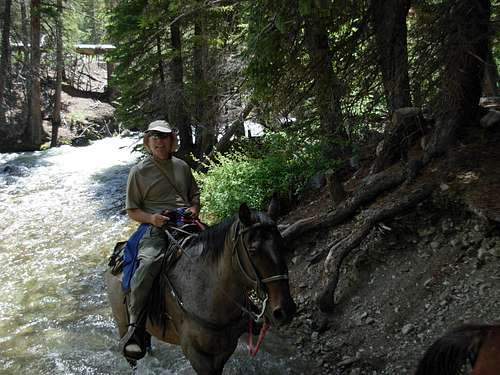
The outfitter’s wife, Mitzi, was sitting at the camp with Ed and Tom, who had passed us on the Glacier Trail shortly before our arrival. By pure luck, Clayton Voss was going to be having Mitzi return their horses to the trailhead the following day and we found out approximately two hours after our arrival that one of the horses could carry Jack’s backpack back to the trailhead… just like Steven’s group was having done. However, Clayton stressed there were no extra saddles available, which meant Jack would need to trek the final 16 miles on his own feet. After seeing Jack hobbling around the camp, barely standing at times, Clayton’s associate Bill agreed to loan Jack his personal saddle so that Jack would not need to walk back to the trailhead. Finally, it appeared Jack was going to be safely returning to the trailhead. Now I could start focusing on my own exit from the backcountry. Upon finding out the horses would only take five hours to travel the final 16 miles, I knew I had to get a jump-start on the descent because it would take me longer and I was not going to have Jack wait for me at the trailhead exposed to either blazing heat or thunderstorms. I knew I had to arrive back to the car, first. Clayton Voss mentioned that Jack’s horse would be able to take my hiking backpack as well as Jack’s, which would also help keep the weights balanced on each side of the horse. I removed the daypack section from my hiking backpack as well as my tent. Right then, Clayton Voss mentioned how when he goes elk hunting he only takes a rainfly for protection from rain. Thinking about this, and knowing my own abilities in the backcountry, I put my tent back into the hiking backpack and only removed the hiking backpack’s raincover. In addition to the clothes I was wearing, I took my windbreaker jacket, backpack raincover, trekking poles, camera, GPS, and daypack containing basic supplies (including Clif “Shot Bloks”, two energy bars, and two 20-ounce bottles of water). I was ready to leave at 4:30 PM, only four hours from sunset, and I wanted to see how far I could get that evening.
Riddles in the Dark
As I left the outfitter’s camp, I passed by a campsite now containing Steven, Rich, Ed, and Tom. I told them the plan for Jack and I, to which Steven asked where I was going to spend the night. I him if I could reach Arrow Pass by, or shortly after, sunset, I was going to go all the way back to the car. Steven thought I was crazy, but I figured the less time I spent alone in the darkness of the backcountry the better. Without a heavy (60-lb) hiking backpack weighting me down, I was making excellent time. A big thunderstorm started as I climbed the steep switchbacks up towards Star Lake, but I was mostly protected by treecover during that stretch of the route. Shortly after arriving at Star Lake at 6:00 PM, all the clouds in the sky seemed to vanish. I then darted down to Double Lake, arriving there at 6:25 PM and stopping to retrieve our hidden food cache (using the “pack it in, pack it out” wilderness motto as my guide). Once I reached Phillips Lake, I noticed the sky was still bright and cloudless. The two miles on either side of Arrow Pass have a lot of exposure due to no real tree protection, making that area a dangerous place to be during a storm. However, with no clouds in the sky, I new this might be my best opportunity. I arrived at Arrow Pass at 8:20 PM, just as the sun started hiding behind the mountains. Plenty of natural light was still available for a while after sunset, and I did not need to use my headlamp until I reached the “30 switchbacks” section of the route shortly before 10:00 PM. As I descended the trail, I made noises with my trekking poles by banging them against rocks, kicked some rocks down slopes to make loud noises, and routinely shined my headlamp all over the area… just to help prevent any potential bear or cougar encounters. I passed the Bomber Basin Trail junction at 10:40 PM, and I arrived back at the trailhead at exactly midnight.
![Gannett Peak Trip - Late Arrival]() Late Night Arrival
Late Night Arrival
Shortly before I arrived back to the trailhead, I thought I had seen some lights near the parking area which went black. When I arrived back at the car, I opened my driver’s side front door and trunk, and then stood by my trunk as I began removing my boots and socks (to change into a clean pair of shoes and socks). In the middle of me doing this, I could hear an automobile engine start and a truck suddenly raced up the road from nearly a block away. It parked in front of my car with its high-beam headlights on. Three young guys (probably somewhere in the 18-21 year old age range) hopped out of the truck and approached me. Two of them were drinking Budweisers while another stood and walked with his hands behind his back. I was cornered. I kept thinking, “I cannot believe this. I have gone through so many obstacles on this trip, only to be taken out by three young thugs.”
One guy in particular did the talking, only wanting to talk about Gannett Peak. I continued putting on my shoes, and closed my trunk (and locked it) as soon as I finished, always keeping my eyes on them. One of the guys went back to the truck. I slowly walked back to my driver’s side front door and sat down, still with my eyes always looking at them and my back to the car. The one guy kept talking about Gannett Peak and asking questions about the hike, but it felt like he was stalling me. As he spoke, I noticed out of the corner of my left eye that the kid who had been having his hands behind his back took out one hand and made a hand-signal to the guy at the truck. Right then, the main guy asked, “People don’t typically walk down the trail at night, like you just did, do they?” With no witnesses around the parking area, I knew I had to quickly take the opportunity to try to outsmart the kids. I responded, “I don’t know about that. My hiking partner is only a little bit behind me, and a big hiking group is coming down with him, too.” The kid paused, looked up at the dark hillside, and asked, “Really?” I stared him in the face and answered, “Now if you will excuse me, I really need to get back to Dubois to get some first aid supplies for an injured hiking partner.” I shut the door and the two guys walked back to the truck, looking up at the hillside. Once inside, I could see the third guy ask, “What happened?” and then all three looked up at the hillside. They drove away, but I could tell they only went a few blocks away. As far as I was concerned, I stood a better chance in that parking area than on the unfamiliar forest road leading to that parking area. Eventually, I could hear the truck driving away. I remained awake until about 1:30 AM, before falling asleep in my driver’s seat for five hours.
The Return Journey
The next morning, I drove to Dubois so I could finally have a cell phone signal again. I called my wife, my parents, my boss, and Jack’s wife. Knowing that Mitzi Voss and Jack would not be returning to the trailhead until sometime between 1:30-2:00 PM, I had plenty of time to explore the town. I first filled-up the fuel tank with gasoline, ate a breakfast burrito, and briefly washed-up in the gas station bathroom. Then I visited the “National Bighorn Sheep Interpretive Center”, Dubois Chamber of Commerce, and Wind River Ranger Station to waste some time. When I the interpretive center, a couple left just as I entered the building. They looked vaguely familiar, and then I was shocked to see they had signed the guest register and listed “Marysville, Washington” (the next-closest city to mine). Small world, I guess, even by Dubois standards.
![Gannett Peak Trip - Jack Horsebacking]() Jack On Horseback
Jack On Horseback
I drove back to the trailhead, arriving at 1:15 PM. I sat by the river along the Old Glacier Trail and waited for Jack’s arrival. Shortly after 2:00 PM, Mitzi, Jack, and the horses came into view and crossed Torrey Creek. As much of an adventure I had getting back to the trailhead area, I was a little envious of Jack’s adventure. Mitzi asked me what time I arrived at the trailhead, and when I told her midnight she looked back at Jack and said, “I told you so.” Apparently, with my look of determination and carrying little more than a daypack, she correctly guessed what I would do. It was just as well, as they had gotten caught in a bad hailstorm at Arrow Pass that morning, something I never had to contend with. After helping unload the horses and saying our good-byes, Jack and I went to Dubois for a celebratory meal: buffalo burgers, fries, and "Snake River Lager" beer. I'm not much of a beer drinker, but anything would have probably tasted good at that point. Then we started up our drive back towards Bozeman. We had allowed extra days for the trip, with Jack scheduled to fly back to Pennsylvania on Thursday (July 16), but he was able to change his schedule to that next morning (Tuesday, July 14). We stayed at a hotel in Bozeman, Montana, for most of the night before dropping him off at the airport and returning home. Jack is a great person. Even despite the hardships felt on the trip, we got along very well with each other and I have a lot of respect for him. Perhaps we will do other climbs in the future… with properly broken-in boots, of course.
As I write this trip report, the true accomplishment of summiting Gannett Peak has not yet sunk in. So many other things were happening during the trip that it might take a while to realize the full scope and intensity of the climb itself. But there is one thing I am certain of. After all I have done and all I went through on this trip, I finally now consider myself a mountaineer.


Comments
Post a Comment