
-
 16397 Hits
-
 79.78% Score
-
 11 Votes
|
|
Mountain/Rock |
|---|---|
|
|
39.80170°N / 76.2896°W |
|
|
423 ft / 129 m |
|
|
Overview
 Wildflowers
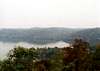
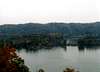
Hawk Point is one of the rare gems when it comes to mountains in southeastern Pennsylvania. Putting aside this summit’s modest elevation, this mountain/hill provides many interesting features. Located within the confines of Susquehannock State Park in southern Lancaster County, Hawk Point overlooks the Susquehanna River and Conowingo Reservoir which straddles the Mason-Dixon Line. With a location of less than an hour drive from Harrisburg, York, and Lancaster, this summit is readily accessible to anyone within south central PA. When compared to the rest of the Susquehanna drainage, this area is one of the rockiest and rugged along the entire length of the river. Hawk Point is focal point within this rugged scenery. With views to the south, west, and north, you’ll be treated to an interesting panorama of the largest tributary to the Chesapeake Bay.
Geologically speaking, Lancaster County has a very complex and diverse geologic history when compared to the rest of the state. The area around Hawk Point was very volcanically active and the evidence is everywhere. Of course it’s been quite a while since large volcanoes inhabited the area, but if you try to imagine it really carefully, maybe you’ll be able to picture what it might have looked like. The evidence on the slopes around Hawk Point can be found in the form of large chunks of Olivine which has crystallized and created a distinction from other rocks with its dark green coloration. You’ll also find pumice, muscovite, and some very nice quartz crystals along many of the trails. The hills within this area are all characterized by a few features as well. They all are very steep sided with flat broad tops. With the river cutting its way through the area, the steepness on the flanks of these hills is magnified even that much more. This area has many technical climbing locations with the most famous being Chickies Rock.
Within the state park you’ll find over five miles of hiking trails. Also, many trails of varying difficulty accommodate even the most novice of hikers. The most challenging is the Rhododendron Trail which climbs up to the overlook at Wissler’s Run. As you hike down/up the Rhododendron Trail you’ll see the huge dam which creates the Muddy Run Reservoir to the northeast of the park. Another interesting point near the trail is a pretty decently sized cave on the opposite hillside near the top of the trail. In the spring and summer you’ll probably have to look a little harder because of the trees, but it’s a very neat place to check out. As stated before, the views are vast from many places along the trail. The other best lookouts include of course, Wissler’s Run overlook and Hawk Point itself.
 |  |  |  |
Susquehannock State Park Overview
Susquehannock State Park is located within southern Lancaster County along the Susquehanna River. The park encompasses 224 acres on a wooded plateau overlooking the river. The park is known for its wonderful overlooks which is all thanks to the 380 foot high cliffs that drop to the river below. The park is also a bird watchers heaven. From osprey to eagles, this is a popular place to spot many different and rare species of birds on the east coast. Fine views of the Conowingo Reservoir exist as well. This reservoir extends for fourteen miles south to its dam in northern Maryland. Also from the summit of Hawk Point you can see the Peach Bottom Nuclear reactors which are cooled by the hydroelectric power generated from the reservoir. Upstream from Hawk Point can be found the Holtwood Dam, also within view of Hawk Point and Wissler’s Run Overlook. There are many recreational opportunities within the park to explore.LANDIS HOUSE HISTORY-
The Landis House is an old stone farmhouse standing near the center of the park on the plateau. It is named for its last owner but was built in 1850 by James Buchannon Long for two hundred dollars. The walls were built with stone from the area along with a cement covering and the house has a slate roof which is all original. The sixth owner of the house, Jacob Schoff, participated in the “Underground Railroad”.
 |  |  |  |
Bald Eagle Sanctuary
Mount Johnson Island was the first bald eagle sanctuary in the world and can be seen down river as the largest island to the south. Two eagles were originally nested there and since have yielded some offspring that have moved up river to the islands just below Hawk Point. Because of the beginning efforts on places like Mt. Johnson Island, more of us can now share the experience of seeing our national bird soar through the sky.Red Tape
There are no permits required to hike in the park. The only needed permit is for group camping within the park. You'll find plenty of room to park throughout the park's one main access road. For conservation purposes follow the “LEAVE NO TRACE” policy and you'll be fine.When To Climb
This mountain is climbable during all times of the year. It is much prettier in fall when the leaves are turning and less people are in the park.Camping
There is one campsite within the state park for tent use only. The organized group campsite can accommodate up to 300 people. For reservations call this toll free number: 888-PA-PARKSGetting There
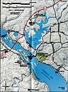
From Harrisburg:Take Interstate 83 south out of Harrisburg all the way to to York. Once you reach the southern part of York City get off on the exit for PA Highway 74 through Red Lion and Dallastown. Stay on this until you reach a turn off for PA Highway 372 on to which you will turn left. You'll then cross the Susquehanna River on a very high bridge and once you reach the other side there will be signs leading to Susquehannock State Park.
From York:
From downtown York get onto PA Highway 74 through Red Lion and Dallastown. Turn left onto highway 372 and continue across the high Holtwood Dam Bridge. From here signs will guide you into the state park.
From Lancaster:
From downtown Lancaster follow PA Highway 272 south through Willow Street until you reach the turnoff for highway 372. You'll travel approximately 15 miles from the downtown area before you reach the right turnoff for 372. From the turnoff, signs will lead you to the state park.
 |
Mountain Conditions
For current and up to date weather conditions click on the link below!weather.com