
|
|
Mountain/Rock |
|---|---|
|
|
35.91320°N / 81.8862°W |
|
|
Burke |
|
|
Hiking |
|
|
Spring, Summer, Fall, Winter |
|
|
4020 ft / 1225 m |
|
|
A Beauty Spot
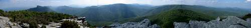
The Stunning Panorama from Hawksbill
Wow. Awesome. Amazing. Any one of these statements may escape your lips the first time you visit Hawksbill Mountain. I believe mine were, "Oh my God..." Located on the East Rim of Linville Gorge Hawksbill is not a giant of a mountain. I barely breaks the 4000' foot barrier. What makes this mountain so beautiful is location, location, location. To the west from its rocky summit is a drop of over 2000' into Linville Gorge. To the east is pristine northern reaches of the Pisgah National Forest. There are very few signs of man from the summit of this peak.

The "Hawksbill?"

Hawksbill Mountain
The slopes of Hawksbill are covered in a forest of mixed pine, rhododendron, mountain laurel and hemlock. There are no (summer) views from the 0.8 mile access trail until you reach the summit. Once at the top though you emerge onto a large open expanse of exposed granite dotted with stunted pines and low brush. There are few panoramas to be found in the southeast like the one from Hawksbill.
Getting There

FR-210
Access to the Hawksbill Mountain Trailhead is along FR-210 which runs along the East Rim of the gorge. The best way to reach FR-210 is off NC-181 about 4 miles south of the Blue Ridge Parkway. The road is paved at first but soon turns to gravel. It is 2.7 miles from the end of pavement to the parking area on the left. The road is usually graded well enough for most vehicles but can be rough during the winter and early spring.
You can access FR-210 farthur south off NC-181 about 7-ish miles from Morganton. This route gives access to the Table Rock area on the way to Hawksbill but can be slow-going and rough due to the heavier traffic headed to the Table Rock area.
Camping & Wilderness Advice

Linville Gorge
Hawksbill Mountain is located in Linville Gorge Wilderness Area.
Camping is allowed anywhere but a permit is required on weekends (Fri-Sun) and holidays between May 1 and October 31. You can obtain a permit by stopping by or writing the District Ranger Office at:
District Ranger
Grandfather Ranger District
109 East Lawing Dr.
Nebo, NC 28761
(828)652-2144
Hawksbill Mountain is not far from the main road so getting yourself in seroius trouble would take a quite a bit of bad luck. However, since this is a wilderness area, you will not find a single sign or blaze. That and the terrain deeper in the gorge makes rescue diffucult to darn near impossible. This means you should always bring yourself a MAP or COMPASS or BOTH. This is especially good advice if you plan on wandering deeper into the wilderness. You could take your family to the summit of Hawksbill but only those who know what they're doing should venture down into the gorge.
Area Trails
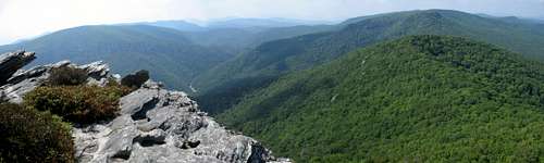 The View North up the East Rim
The trail to the summit of Hawksbill begins from the parking area on FR-210. After about .5 miles the summit trail breaks left just before reaching the Jonas Ridge Trail. From here the summit trail gets progressivly rockier and, after .25 mile, breaks out onto the ridge. There won't be much to see from this point so follow one of the numerous but overgrown trails to the right and make your way a short distance up to the open summit.
If you desire a bit longer hike you can follow the Jonas Ridge Trail north along the ridge from where it breaks off the Hawksbill Trail. At 0.6 miles a spur trail breaks right to FR-210. At 0.8 miles the Devils Hole Trail heads left 1.5 miles into the gorge. The Devils Hole Trail is an out-and-back hike. It ends at the Linville River in one of the least-visited sections of Linville Gorge.
The Jonas Ridge Trail continues north from Devils Hole Trail for another 1.4 miles. It climbs Sitting Bear(4080') & Gingercake(4120') Mountains with numerous beatiful views along the way. At 2.2 miles from the Hawksbill Trail the path ends at a grassy area that used to be the site of an old cabin. From here you have to retrace your route back to the parking area.
Online Resources
North Carolina National Forests
NC Natural's Linville Gorge Page
A good page for general info about the Linville Gorge Area
Linville Weather from Ray's Weather Center
Finding a good local weather forecast in the High Country can be hard to find. Ask any local Ray's Weather is the best!
National Geographic Trails Illustrated Maps
From this page you can browse National Geographics ever-growing series of excellent topo/trail maps. As of May 2006 they released one for the Linville Gorge/Mt. Mitchell areas (#779).
DWhike's Adventures - Shameless self promotion...come visit my website for more pics of Hawksbill Mountain and other places that I have wandered off to in recent years...