
-
 8285 Hits
-
 82.34% Score
-
 15 Votes
|
|
Area/Range |
|---|---|
|
|
46.87714°N / 10.86098°E |
|
|
Hiking, Mountaineering, Trad Climbing, Ice Climbing, Mixed, Scrambling, Skiing |
|
|
Spring, Summer, Fall, Winter |
|
|
12375 ft / 3772 m |
|
|
1 - Overview
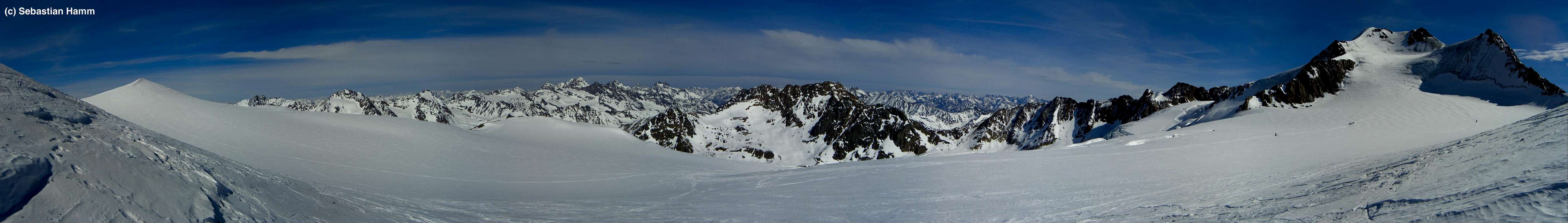
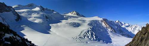 Wildspitze and Hinterer Brochkogel (Sebastian Hamm) |
Weisskamm (German: White Crest) is the central and highest subgroup of the Ötztal Alps. As the name implies, it is heavily glaciated and indeed it carries the largest consecutive glaciers of the eastern Alps: Gepatschferner and Mittelbergferner belong to the largest single glaciers and together with Kesselwand-, Vernagt- and Taschachferner the cover is complete. With Wildspitze and Weißkugel, Weisskamm is home to the two highest mountains of the Ötztal Alps, which at the same time are No 2 and No3 in the list of Austrian peaks after remote Großglockner in the Hohe Tauern Range.
Weisskamm is a broad ridge of roughly 20km length, which starts with the ski slopes to the west of Sölden and runs in WSW direction. Its highpoint, Wildspitze, is close to the centre of the ridge, while iits second culmination point, Weißkugel is located near its western end. In general it is difficult to distinguish different ridges or subgroups, since the summits don't exceed the big glacier field by far. This is a general feature of the Ötztal Alps - huge glacier covered sloped plains are broken by summits which rise for some 200m from the glaciers.
 Wildspitze |  Weißkugel |  Fluchtkogel |
Since it is the central feature of the Ötztal Alps, Weisskamm connects to almost all other subgroups of the range The separation from the other subranges is not very distinct, often there are high passes, which themselves are often higher than or almost 3000m high.
- To the south, Weisskamm is bounded by Venter Tal, Rofental and Hochjoch / Giogo Alto (2861m), which separates it from the Ötztal Alps Main Ridge. Upper Schnalstal / Val di Senales and Steinschalgtal / Valle delle Frane lead westward to Quelljoch (3349m), the saparation of Weisskamm and Saldurkamm.
- To the west the separation from Planeiler Berge is Bärenbartjoch (3302m)
- To the north Weißseejoch (2965m) separates Weisskamm from Glockturmkamm, Wannetjoch (roughly 3200m) from Kaunergrat and Pitztaler Jöchl (2996) from Geigenkamm.
- To the east Weisskamm runs out into Ötztal between Sölden and Zwieselstein.
 Wiesjagglskopf |  Weißkugel north ridge |  Südl. Sexegertenspitze |
Touristically, Weisskamm is best known for the Ski runs above Sölden, where roads run up to almost 3000m to make use of the glaciers around Karleskogel and Innere Schwarze Schneid. In the north, in Pitztal and Kaunertal, there are additional glacier ski runs while the southern ones near Hochjoch don't survive the summer months any more.
There are several panoramic hiking trails in the south of the range above Venter Tal but Weisskamm is more or less reserved for ski tourers in winter and mountaineers in summer. Apart from Wildspitze (and its vicinity like Hinterer Brochkogel) and Weißkugel the most popular mountains are the ones on the rim of Gepatschferner, namely Weißseespitze and Hintere Karlesspitze. Naturally, wherever there is a ski lift the mountains around it are climbed as well but most often you reach the summit by lift directly.
 Pitztaler Urkund |  Hinterer Brunnenkogel |  Fluchtkogel |
Historically, Weißsejoch and Hochjoch have been trade and transhumance routes between the northern and southern parts of the Ötztal Alps. Hochjoch in particular is still used for these purposes. Twice a year in Spring and Autumn, sheep are driven from and to the Südtirol Valleys across the saddles onto the meadows in Rofental in the north. Nowadays it is a big touristic attraction in both Rofen and Kurzras.
2 - Weisskamm on SP
  |
3 - The Summits
- Gaislacher Kogel (3050m)
![]()
- Äußere Schwarze Schneide (3257m)
![]()
- Innere Schwarze Schneide (3369m)
![]()
- Karleskogel (3107m)
![]()
- Pitztaler Jochkopf (3023m)
- Linker Fernerkogel (3278m)
![]()
- Rechter Fernerkogel (3298m)
![]()
- Tiefenbachkogel (3309m)
- Mutkogel (3312m)
![]()
- Weißer Kogel (3409m)
- Taufkarkogel (3367m)
![]()
- Wildes Mannle (3019m)
![]()
- Karleskopf (2901m)
![]()
- Grabkogel (3052m)
![]()
- Mittagskogel (3162m)
![]()
- Mitterkamm (3222m)
- Mitterkopf (3347m)
- Vorderer Brunnenkogel (3393m)
- Hinterer Brunnenkogel (3440m)
![]()
- Schluchtkogel (3472m)
- Wildspitze (N:3772m, S:3770m)
![]()
- Ötztaler Urkund (3556m)
![]()
- Hinterer Brochkogel (3635m)
![]()
- Vorderer Brochkogel (3565m)
![]()
- Schwarzkögele (3070m)
- Petersenspitze / Taschachwand (3484m / 3358m)
![]()
- Hochvernagtwand (3400m)
- Pitztaler Urkund (3201m)
![]()
- Hochvernagtspitze (3539m)
![]()
- Sexegertenspitzen
- Südliche Sexegertenspitze (3429m)
- Nördliche Sexegertenspitze (3350m)
![]()
- Südliche Sexegertenspitze (3429m)
- Schwarzwandspitze (3467m)
![]()
- Hintergraslspitzen (3270, 3325m, 3313m, 3417m)
- Rauhe Köpfe (2990m, 2880m)
- Fluchtkogel (3500m)
![]()
- Ehrichspitze (3425m)
- Dahmannspitze (3401m)
![]()
- Kesselwandspitze (3414m)
![]()
- Gulslarspitzen
![]()
- Hintere Guslarspitze (3151m)
- Mittlere Guslarspitze (3126m)
- Vordere Guslarspitze (3118m)
- Hintere Guslarspitze (3151m)
- Mutspitze (3257m)
![]()
- Hintereisspitzen
- Vordere Hintereisspitze (3437m)
- Mittlere Hintereisspitze (3451m)
- Hintere Hintereisspitze / Punta della Cresta Bianca (3486m)
![]()
- Vordere Hintereisspitze (3437m)
- Hochvernaglwand (3435m)
- Vernagl / Vernaga (3355m)
![]()
- Langtauferer Spitze / Punta di Vallelunga (3529m)
![]()
- Weißkugel / Palla Bianca(3739m)
![]()
- Innerer Bärenbartkogel / Cima Barba d'Orsa di Dentro (3557m)
- Innere Quellspitze / Cima della Sorgente di Dentro (3516m)
- Teufelsegg / Cresta del Diavolo (3227m)
- Im Hintern Eis / Punta della Vedretta (3270m)
- Steinschlagspitze (2861m)
- Adlerkopf (3200m)
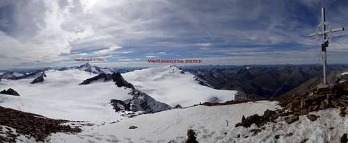
- Weißseespitze (3526m)
![]()
- Falginer Karlesspitzen
- Vordere Karlesspitze (3231m)
- Hintere Karlesspitze (3160m)
![]()
- Vordere Karlesspitze (3231m)
- Wiesjagglkopf (3130m)
![]()


4 - Getting There
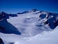
Gepatschferner from Fluchtkogel (Blaze334)
- Eastern Access
This is the easiest way to reach Weisskamm:
- Take the road through Ötztal Valley, which connects the Inntal Valley in the north with Meran / Merano in the south.
- At Sölden take the road into Venter Tal Valley which leads to the south side of Weisskamm
- Take the road through Ötztal Valley, which connects the Inntal Valley in the north with Meran / Merano in the south.
- Northern Access
- From Imst take the road into Pitztal Valley as far as you can get
- From Landeck take the road into Kaunertal Valley, again as far as you can get
- From Imst take the road into Pitztal Valley as far as you can get
- Western Access
- Take the road from Graun / Curon near Reschenpass / Passo di Resia into Langtauferer Tal / Vallelunga
- Southern Access
- From Vinschgau / Val Venosta take the road into Schnalstal / Val Senales until its end
- From Schluderns / Sluderno (also in Vinschgau / Val Venosta) drive into Matscher Tal / Val di Mazia
- From Vinschgau / Val Venosta take the road into Schnalstal / Val Senales until its end
5 - Accommodation
 |
On both sides of the border you have the choice among a lot of hotel rooms and apartments. Here is a selection of links:
- Ötztal accommodation
- Pitztal accommodation
- Kaunertal accommodation
- Vinschgau / Val Venosta accommodation
- More Vinschgau / Val Venosta accommodation
- Schnalstal / Val Senales accommodation
Mountain Huts
| Refuge / Hut | Height | Summer | Winter | Tel. | Thumbnails |
| BraunschweigerHütte | 2759m | mid June - end Sept. | self service for 11 | +43/5413/86236 |  |
| BreslauerHütte | 2844m | end June - end Sept. | self service | +43/5254/8156 |  |
| Vernagthütte | 2766m | end June - mid Sept. | beg. March - mid May | +43/664/1412119 |  |
| Hochjochhospiz | 2413m | end June - end Sept. | mid March - mid May | +43/664/540 25 74 |  |
| BrandenburgerHaus | 3272, | beg July - mid Sept. | n.a. | +39/0340/4154306 |  |
| Rauhekopfhütte | 2731m | beg. July - mid Sept. | self service for 12 | +43/664/5349044 | |
| Weisskugelhütte | 2542 | end June - mid Oct. | beg April - end May on weekends | +39/0473/633191 |  |
6 - Red Tape
Several Areas in the Ötztal Alps, Among them part of the western Weisskamm have been declared Ruhezone, Calm Zone. In these Zones Animals may not be disturbed in certain times of the year, mainly Spring and winter. Hunting is strictly forbidden, even entering the zones is not allowed. There will be signs along the regular hiking trails whenever you are entering one of these zones. Please follow the rules announced on them.7 - Weather Conditions
8 - Maps & Books
8.1 - Maps
The best maps are the ones by Deutscher Alpenverein (German Alpine Club) for Ötztaler Hauptkamm there are two:
- Ötztaler Alpen, Weißkugel
Map No: 30/2
1:25000
ISBN: 978-3928777391
- Ötztaler Alpen, Wildspitze
Map No: 30/6
1:25000
ISBN: 978-3928777452
Kompass has some very good overview maps, scaled 1:50000 which show all the neccessary trails but don't go into too much detail:
- Ötztaler Alpen
Kompass Map WK43
1:50000
ISBN: 3-85491-049-5
- Vinschgau / Val Venosta
Kompass Map WK52
1:50000
ISBN: 3-85491-058-4
8.2 - Books
- Ötztaler Alpen
W. Klier
Alpenvereinsführer
Rother Verlag
ISBN: 3-7633-1123-8
- Ötztal
H. & W. Klier
Rother Verlag
ISBN: 3-7633-4094-7
- Pitztal
H. & W. Klier
Rother Verlag
ISBN: 3-7633-4058-0
- Vinschgau / Ortlergruppe
Kompass Wanderbuch 950
Kompass Verlag
ISBN: 3-87051-404-3
Overview books (both out of print) with 20+ routes in the Ötztal Alps
- Ötztaler Alpen, Silvretta, Ferwall (Bergwandern und Bergsteigen zwischen Timmelsjoch, Reschen und Arlberg)
S. Schnürer
BLV München 1990
ISBN: 3-405-13171-5
- Bergsteigen in Südtirol Band 2 (zwischen Bozen und Reschen)
S. Schnürer
BLV München 1982
ISBN: 3-405-12212-0