
|
|
Canyon |
|---|---|
|
|
40.43111°N / 109.16839°W |
|
|
Hiking, Trad Climbing, Scrambling, Canyoneering |
|
|
Spring, Fall |
|
|
Overview
So, do you like really remote peaks and territory? This is a really nice surprise. Pull open any guidebook to Colorado and Utah with the hikes and climbs marked, and notice the big blank spot in Northwestern Colorado and Northeast Utah. The peaks in this area are incredibly spectacular and almost completely ignored, despite the fact that it offers some of the best scenery in the lower 48 states. There is enough exploring here to keep one busy for years.There are all kinds of spectacular canyons here as well. From big and scenic to tight slot canyons, this area has enough exploring left for years. There are literally dozens of seemingly completely unexplored slot canyons in the area.
Hog Canyon is one of those canyons. It wasn't descended in its entirety until June 2016.
The canyon is an impressively rugged gorge cutting through thick sandstone layers in Dinosaur National Monument. It also guards its secrets well and most of the canyon is seemingly inaccessible. The lower end of the canyon is a gentle and friendly place with a crystal clear stream gurgling through ambient grassy meadows. A century ago, Josie Morris homesteaded the area and kept the lower part of the canyon as a corral since animals couldn’t go very far up the canyon.
Although I had been hiking in Dinosaur National Monument since at least the early 1980’s, Hog Canyon was the earliest of the technical canyons that I attempted in the Monument. This was in April 2003. It took four tries over a 13 year period to finally descend the canyon.
As mentioned, the very bottom of Hog Canyon is warm and inviting, but with big scenic walls, but the upper end of the canyon has a huge headwall. What lay between these two locations was a big question mark until 2016. I knew that it wasn't a tight and classic slot canyon, but I still wanted to descend the canyon and its impressively deep gorge.
We discovered that the canyon was both a beauty and a beast. If you want to descend it, here is the information.
 Me on the last stage of a 400+ foot drop in Hog Canyon (Dinosaur National Monument) yesterday. We made the first descent of the canyon, but didn't get too many photos. It was beautiful, but difficult; 11 hours to go two miles.
  The pleasant and easy section of lower Hog Canyon. It is totally different from the upper and middle sections!
 Getting There
Lower TrailheadTo get to the trailhead, you must first drive to the Dinosaur Quarry Visitor Center in Dinosaur National Monument, which is east of Vernal. Use a Utah Road map for the drive. After obtaining updated information (the visitor center will have no information on climbing the mountain itself, but is helpful on road and park conditions) from the visitor center, drive east on the Cub Creek Route and turn left at sign for Josie Cabin and Hog Canyon.
 McKenzie and Holly scrambling up the approach on the east rim of Hog Canyon. This isn't far from the trailhead.
Upper Trailhead
Follow direction above, but turn right on the gravel Blue Mountain Road and follow it to the top of the plateau. With a good map in hand, you want to head west towards the Yampa Plateau along dirt roads which get progressively rough as you head west. The road eventually turns into a 4wd road. Park just before the road drops into Docs Valley. the road dropping into Docs Valley is extremely rough and washed out.
 Hog Canyon Map.
Route
These directions are very brief as it is assumed that all canyoneers descending the canyon will have experience and route finding ability. There are at least six rappels and several 5th class downclimbs. A minimum of two 60 meter/200 feet ropes are requires as well as several slings and rappel rings. An easy section of Middle Hog Canyon. The narrows can be seen far below.
Top Down
From the trailhead, follow the old road down into Docs Valley and then north and west around Point 7613 and to the head of the drainage draining into Hog Canyon. Follow this drainage downstream, while negotiating several obstacles such as brush, boulders, and minor drop offs. You will eventually reach the headwall of the canyon, a huge pourover and drop of several hundred feet.
 A zoom shot of lower Hog Canyon as taken from high on the bench near the headwall.
From the big drop, retreat back up canyon until you can climb west up to the first bench above the big drop (there is a bench at the same level as the big drop, but I don't know if it goes). Follow this bench west to it's end.
There is a secure tree that makes an anchor for stage one of the 400 foot drop. All anchors are done with trees or bushes. (I stuck my rope on the 2nd stage and it is still there. If you find it, I'd appreciate it being returned!).
Scramble down canyon, staying in the drainage. There are several downclimbs and rappels, but none are as high as the initial drops.
 Rappel #5.
 Last Rappel.
Once you are at the bottom of the last rappel, there is still lots of scrambling and boulder-hopping, but the major difficulties are over. Once you reach the spring, a good trail takes you to the lower trailhead.
Plan on most of a day to complete this route.
Options
A really good rock climber might consider an attempt of reversing our route, but it won't be easy.
As an alternate route, you can climb to the rim from the lower trailhead, staying well away from Hog Canyon so you don't get cliffed out, and then descend.
 We got cliffed out staying too close to the canyon rim.
 When to Climb
Spring or Fall are the best times to descend this canyon. The canyon faces south and there is little shade, so the heat in summer can be intense. The road to the trailhead might not be open until May, so winter would be difficult. Kessler in Hog Canyon during a hot day in June.
Red Tape
Federal law protects all archaeological sites. Do not disturb them.Park entry cost $20 per vehicle in 2016.
Treat the canyon with respect.
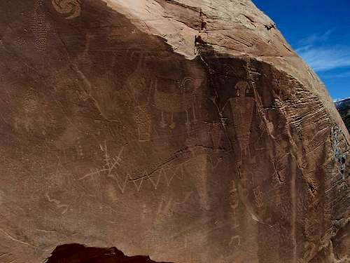 Petroglyphs not far from the mouth of Hog Canyon. Please treat the area with respect.
 Camping
Split Mountain campground and Green River Campgrounds aren't that far from the trailhead. Split Mountain Campground is now only a group site. For more information call the park headquarters at 801-789-2115.Canyon Conditions
Contact the rangers at the Dinosaur National Monument Headquarters at 801-789-2115 for updated conditions.Here is a LINK to the monument web page.
WEATHER FORECAST FOR HOG CANYON
Weather and climate data for the Dinosaur Quarry is below. *National Weather Service Data 1958-2004.
| MONTH | AVE HIGH | AVE LOW | REC HIGH | REC LOW | AVE PRECIP (in) |
| JAN | 30 | 4 | 60 | -39 | 0.51 |
| FEB | 39 | 11 | 66 | -40 | 0.62 |
| MAR | 54 | 24 | 85 | -15 | 0.65 |
| APR | 65 | 33 | 89 | 10 | 0.78 |
| MAY | 77 | 41 | 103 | 20 | 0.86 |
| JUN | 88 | 49 | 105 | 30 | 0.61 |
| JUL | 95 | 55 | 110 | 35 | 0.62 |
| AUG | 92 | 53 | 106 | 35 | 0.64 |
| SEP | 82 | 44 | 103 | 20 | 0.98 |
| OCT | 67 | 32 | 93 | 2 | 1.06 |
| NOV | 49 | 22 | 74 | -10 | 0.60 |
| DEC | 35 | 10 | 61 | -33 | 0.56 |