
|
|
Route |
|---|---|
|
|
46.38696°N / 7.39861°E |
|
|
Hiking |
|
|
Most of a day |
|
|
easy |
|
|
Overview
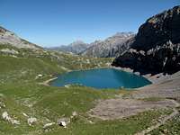
The route I'm describing here is a round trip that's set in the beautiful and spectacular alpine surroundings of Lenk im Simmental, not difficult at all - there are well-marked and sign-posted paths all along the way - and very typical for the bernese Alps. It can be easily done in six hours, with rests on the Iffighorn summit and the Wildhorn Hut. I did it in late summer, in fantastic weather. The highest point reached is the grassy summit of Iffighorn, 2378 meters, which is maybe not a spectacular summit in itself, but offers a great view over a large part of the bernese Oberland. One starts and ends this tour in Iffigenalp upon 1584 meters, 8 km south of Lenk. View from the path to the Iffigsee mountain lake and towards the Wildhorn hut
This particular route, which entices in summer by the contrasts of water, rock and rich green, is also very well known as a skiing tour in winter - if anybody has winter photos of this area, please feel free to attach them to this page!
Getting There
Lenk im Simmental, which is very close to the world-famous resort of Gstaad, is a lovely and peaceful mountain village with several excellent hotels, open all year around. Just a quarter hour's walk from Lenk is the tiny Lenkseeli lake, from which you can often enjoy views like this!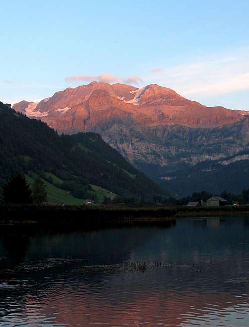 The Wildstrubel in alpine glow seen from the Lenkseeli
Nearest airports: Zürich, Basel, Geneva
Coming by car from Zürich: Follow the motorway N1 to Bern, then the N6 to Spiez. Exit at Spiez and follow the road to Zweisimmen. At the roundabout in the center of Zweisimmen, turn left and head for Lenk, which is reached after another 13 km. In Lenk, turn right and follow the road 8 km up to Iffigenalp (the road is slightly rough here and there). Distance Zürich-Iffigenalp: 210,7 km, duration: 2h 40 min.
Coming by car from Basel: Take the motorway N2 in the direction of Bern/Zürich/Luzern; at crossroads switch to the N1 in the direction of Bern, then continue as indicated above. Distance Basel-Iffigenalp: 183,2 km, duration: 2h 23 min.
Coming by car from Geneva: Follow the motorway N1 as far as above Lausanne, then switch to the N12 direction Fribourg-Bern and follow it until Bulle, exit the motorway here and follow the signs to Jaunpass-Boltigen. In Boltigen, turn right and pass on to Zweisimmen. From here, continue as indicated at the top. Distance Geneva-Iffigenalp: 181,1 km, duration: 2h 34 min.
Coming by means of public transportation: From Zürich: Take the fast direct train bound towards Interlaken or Visp-Brig as far as Spiez, change here to the regional train to Zweisimmen, then change to the MOB train to Lenk. In Lenk, use one of the post-busses that commute regularly between Lenk and Iffigenalp. From Basel: Take the fast train bound for Interlaken or Visp-Brig, alight in Zweisimmen and continue as indicated above. From Geneva: Take the fast train bound for Sion-Brig-Milano as far as Montreux. Here, change to the MOB train to Zweisimmen (a fairly slow but very enjoyable trip through the Pays d'Enhaut!) and in Zweisimmen, change to the MOB local train to Lenk. From here, take the post-bus up to Iffigenalp.
Route Description
 On the path between Iffighorn and Wildhorn hut
Start in Iffigenalp, 1584 meters. Follow the path SW up the valley and the 500-meter-rise to the Iffigsee upon 2065 meters. Continue following the path high up above the northern shore of the lake, following the signs indicating Tungelpass-Lauenen. At crossroads, after ca. 1 km, turn to the right and follow the path leading straight up to the Iffighorn upon 2378 meters. From Iffigenalp to Iffighorn it takes about 2,5 hours. Go down from the summit the same way until the crossroads mentioned, then follow the right-hand path leading high up above the Iffigsee, through a high valley and a 100-meter-rise to the Wildhorn hut upon 2303 meters (see the External Links section), the base for an ascent of the Wildhorn (3248 meters) and quite spectacularly situated in a scree and moraine environment. This section reqirues something between 1,5 and 2 hours. From the hut, go back to crossroads, turn right and follow the path (the same path as coming up) past the Iffigsee back down to Iffigenalp. For this I would count 2 hours.
 View to Schneidehorn and Wildhorn from the Iffighorn
 Looking back to the Iffigsee lake, with the Wildstrubel showing in the background
 The high valley leading to the Wildhorn hut
 View from the top of the Iffighorn to the Wildstrubel and the bernese pre-alps
I should like to mention an alternatve: one can also first go up to the Wildhorn hut (there is a direct path leading along the scree-covered east shore of the Iffigsee and then straight up the valley to the hut), then up Iffighorn, and follow the path leading down the broad, hill-like ridge named Hohberg from the summit straight to Iffigenalp. There are no difficulties on this descent either and one has a lovely panorama for a long part of the way!
Essential Gear
Apart from the basics - good mountain shoes and good weather protection - no extra equipment is required.External Links
Information about the Wildhorn hut (in german and french)The mountain inn at Iffigenalp (in german)
Weather forecast for Switzerland
Information about Lenk
On this page you will find timetables (PDF) of the buses commuting between Lenk and Iffigenalp, as well as to other places in the area around Lenk.