
-
 9827 Hits
-
 83.1% Score
-
 16 Votes
|
|
Mountain/Rock |
|---|---|
|
|
36.49910°N / 115.948°W |
|
|
Nye |
|
|
Hiking, Bouldering, Mixed, Scrambling |
|
|
Spring, Summer, Fall, Winter |
|
|
6565 ft / 2001 m |
|
|
Overview

Getting There

Continue on HWY 95 for 11.3 miles.
Make a left turn onto the dirt road. Drive on this road for 5.9 miles.
You will reach a fork with a sign marking County roads 553 and 555. Take the right fork (553).
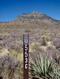
Continue driving for 3.8 miles and take a left turn onto 553C. This is just a little bit past the main cliff you can see on Jaybird’s SE face.
Drive on 553C for 0.1 miles and then you will reach a T-Intersection, which is 553A.
Turn right onto 553A. Drive for 0.4 miles and you will see a small area to park on the left side of the road.
NOTE: This should be done in a high clearance vehicle. Once you are there you might be tempted to take 553A North instead of going back to 553C and back onto 553. There are some areas just around the parking area where if one isn’t careful you could tip your vehicle over the side. I highly suggest driving out the way you came in.
Red Tape
There is none. Jaybird is on National Forest Land.Camping
Basic hotel accommodations can be found at Indian Springs, about 12 miles south on HWY 95 from the dirt road.There are no developed campgrounds around Mt. Stirling or Jaybird. You can find some over in Kyle and Lee Canyons around Mt. Charleston.
Primitive camping can be enjoyed in the area around here and Mt. Stirling. There is no water.
When to climb
Mountain Conditions for the Spring Mountains can be obtained by contacting the Kyle Canyon Visitors Center. Their number is 702-872-5486.
The Hike
Refer to the Jaybird from the Southeast route. This is the shortest route to the summit.Summit Shots
 |  |