
|
|
Mountain/Rock |
|---|---|
|
|
33.64100°N / 116.5711°W |
|
|
Riverside |
|
|
Hiking |
|
|
Spring, Summer, Fall, Winter |
|
|
6868 ft / 2093 m |
|
|
Lions?
 Did someone say "lion?!"
The views along this section of the PCT are breathtaking; the entire Santa Rosa range to the south, the San Jacinto Wilderness to the north, the Coachella Valley to the east, and Garner Valley, Thomas Mountain along with Lake Hemet to the west all seen quite clearly year-round. Many of the Hundred Peaks Section peaks in the 7000’ range are found here and easily accessed off the PCT.
Named by the USFS in 1960 after our native California Mountain Lion (Felis concolor), also called catamount, cougar, panther, and puma. Lion Peak avails its summit as an easy access off the Pacific Crest Trail. Being near the southern most end of the San Jacinto range, this peak affords clear views of Pinyon Flat and the Santa Rosa Mountain range more than San Jacinto. The dense pines at the summit are partially to blame as are the taller peaks to the north. Neighboring Pine Mountain and Devil’s Rockpile are in constant view and provide a significant landmark.
Lion Peak is a relatively small peak regarding its mass; it is barely ¼ mile in width at its widest. As the northeastern face provides the easiest ascent, albeit Class 2 near summit, all other sides are strewn with large boulders and/or thick forest. Lion’s southwestern flanks proudly exhibit a wonderful array of gigantic boulders and granite walls; access not granted from summit due to steepness and brush.
Lion Peak added to HPS list in 1961.
OK, I have seen plenty of mountain lion paw prints out here before!
Driving There
From I-15, north or southbound, you can exit in Temecula onto Winchester Road (Hwy 79N) and head north to Hwy 74E and continue on through Hemet and up the slope on pleasant winding mountain roads, complete with competition "S-curves" to Mountain Center. Once you reach Mountain Center at the intersection of Hwy 243 to Idyllwild and Hwy 74 to Palm Springs, stay to your right and on the 74. In approx 8.5 miles, you will reach Morris Ranch Road on your left, a fire station sits on the corner. Turn left here. Cedar Springs trailhead.
Or you may exit in Temecula onto Hwy 79S and drive east toward the San Jacinto Mountain range for approx 20 miles, then turn left onto Hwy 371 for Anza. In another approximate 20 miles up a long slow grade to about 4500' through dry rocky terrain, passing the Temecula Olive Oil Company ranch and Cahuilla Casino, you will reach Hwy 74 bound for Palm Springs to the east and Mountain Center to the northwest. Turn left at Hwy 74, there is a nice restaurant on the right hand corner, Paradise Corner Cafe; probably the ONLY good place to eat for many, many miles. Approx 3 miles after turning left, you will come upon Morris Ranch Road on your right with a fire station on the corner, turn to the right here. You will pass a sign for the trailhead to Thomas Mountain on your left just prior to reaching Morris Ranch Road.
Once on Morris Ranch Road, drive approx 3.75 miles, passing the Joe Scherman Girl Scouts of America Camp and many mobile homes. On the right, you will come to a gate with a sign for "Cedar Springs Trail." Park in the vicinity and be sure to post your National Adventure Pass.
Hiking In
From the gate at Cedar Springs Trail trailhead on Morris Ranch Rd, begin your 4-mile trek to Pine Mountain. You will have no choice but to stay on “The Trail” due to the barrage of “no trespassing” signs, wire fences and gauntlet of gates (there are 4 of them). There are even picnic tables and a trash can along the way.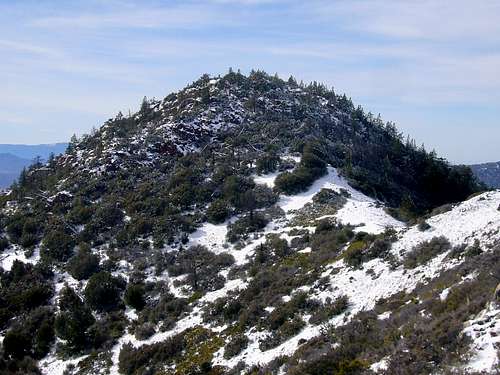 Lion Peak from the PCT.
At the third gate, you will finally be entering the National Forest boundary and feel you have escaped the confines of bureaucracy, but wait….one more gate…. The gentle switchback trail takes you to the PCT for another 1.5 miles; great view of the canyon and surrounding area along the way, but as this portion of the trail remains in the sun, take care to protect yourself from the heat and rays. The only running water can be found dribbling from a pipe in the clearing near the picnic tables.
At the saddle of PCT and Cedar Springs Trail junction, turn right and continue to march east, then south for approx another 1.5 miles, passing Little Desert and Pyramid Peak. If you’re interested, there will be a small pile cairn on your right for climbing trail to Pyramid Peak. Otherwise, continue on PCT just passed Pyramid Peak for another mile. You will drop slightly into another saddle between Pine Mountain and Lion Peak. At this point, continue straight onto shoulder of Lion; there is an obvious cairns on the right side of the PCT. March up shoulder in southwestern heading, passing a couple more clear cairns, keeping them on your left and press on through the woods. Take care, as there are many many large downed trees for the next 50-60 feet of elevation gain. Ascent will turn to Class 2 boulder scrambling.
 Lion's cozy summit.
Summit is marked with large boulders and a couple of dead trees (along with the living ones). Register can is stashed between boulders. Enjoy the view to your southeast…that’s about all you can see.