
|
|
Mountain/Rock |
|---|---|
|
|
33.81228°N / 116.65644°W |
|
|
Riverside |
|
|
Hiking, Mountaineering |
|
|
Spring, Summer, Fall, Winter |
|
|
9369 ft / 2856 m |
|
|
Overview
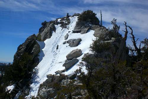 The Summit
Yale Peak is a striking unnamed peak located in the San Jacinto Mountains, part of the Peninsular Range. It is SE of its more popular neighbor, Cornell Peak. Cornell and Yale Peak both appear as rugged pinnacles when viewed from Round Valley. Most people simply pass it up along their way to San Jacinto Peak. However, Yale Peak makes a nice side addition when climbing San Jacinto Peak or if you are just in the Round Valley Area. Also, the views from this peak are amazing, with drop dead views of the desert and of the of the rest of the San Jacinto Mountains.
As mentioned above, this is an unnamed peak. However, it is referred to as "Yale Peak". Read this thread regarding it's name. Bob Burd referred to it in a trip report as "Bloody Pinnacle" (read the trip report and you will know why). Other various names have been used, but from what I have found out and found from others, it is commonly called Yale Peak after the college mostly likely due to the fact that Cornell Peak is also named after a college.
Yale Peak has around 180ft of prominence and is roughly .40 miles SE from Cornell Peak. The easiest route up is Class 3, which can be found on its NE and NW slopes. Its southern face is a vertical 300ft wall.
Route Info
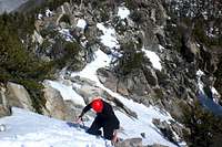 Down Climbing
 The Tricky Section
By far the easiest way to access this peak is by the Palm Springs Aerial Tram. However, it can also be accessed via any other trail that leads to San Jacinto Peak.
If your coming from Humber Park (Devil's Slide), you will need to cross over Wellman's Divide down into Round Valley. Continuing a little further you will reach Tamarack Valley. From here, head East (maybe NE) to a saddle that is between Harvard Peak (a sub peak of Cornell Peak).
From any of the trails that come up the South face of San Jacinto, you will need to traverse San Jacinto on down into Round Valley (these routes are probably the longest routes possible to get to this peak)
From the Palm Springs Aerial Tram, head West until you reach the saddle between Harvard and Yale. As said before, this is the shortest and easiest route. Its a little over a mile from the tram to the saddle.
Once at the saddle, you can begin climbing Yale's NW face. An easy route should appear that traverses NE. Follow this and it leads you to a little ridge. Once atop the ridge, the summit block will come into view. It gets quite steep and a little exposed. This is a Class 3 route.
Without snow, you will have alot of rock and manzanita to contend with. In the winter, snow will cover up most of this.
 SE Face Routes
 NW Face Routes
Camping
 Facilities
Camping is located very close in Tamarack Valley or in Round Valley. In the summer, these campgrounds fill up fast. See the ranger station for more details. Always bring plenty of water.
Red Tape
A Wilderness Permit is required for entering theMt. San Jacinto State Park. These can be attained online or at the ranger stations.Also, to park at trailheads (with the exception of the Tram, an Adventure Pass is required.
Getting There
 The Three Pinnacles
From Idyllwild-
Humber Park (Devil's Slide)- From Hwy 243, take a right (if your heading north) and take a left (if your head south) onto Pine Crest Ave. Then take a small right at S. Circle Dr. Then take a left at Fern Valley Road. Follow Fern Valley Road all the way to Humber Park.
Marion Mountain Trail- Head North on Hwy 243. After a few miles, there will be a sign on the right side. Follow that to the Trailhead.
For the Palm Springs Aerial Tram, click HERE for directions.
External Links
San Bernardino National ForestSan Jacinto Ranger District
54270 Pine Crest
P.O. Box 518
Idyllwild CA 92549
(951)-659-2117
Mt San Jacinto State Park
29505 Hwy 243
P.O. Box 308
Idyllwild CA
(951)-659-2607
Mt San Jacinto State Park
For info on current condition, check out the Mt San Jacinto Message Board.
For weather conditions, click THIS LINK.
Misc
If you have any addition information or pictures not already on this page feel free to post them. Thanks!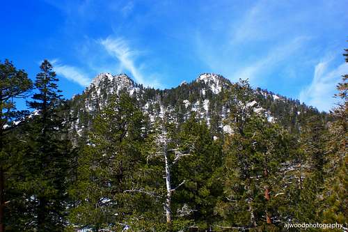 Yale and Harvard