Previously in Four months in Peru: A Peruvian fiesta, struggling with deep powder and making new friends.
A lazy day
![The center of Cuzco]() Cuzco
CuzcoI'm oblivious at first, but then I realize that I'm an anomaly and I begin to smile. All the other tourists take pictures of just about everything in Cuzco, while I simply stroll around the vibrant city, soaking up the atmosphere, and completely forget to take out my camera. It's not that I'm a philistine, it's just that I'm still on cloud nine after my memorable trip to the Cordillera Vilcanota. And, granted, the historic buildings in the town center are pretty enough, but they are simply not in the same league as the breathtaking mountains I just came from.
After all the strenuous exercise, I was enjoying a well deserved rest day. My main goal, apart from doing nothing? Well, if you happen to find yourself in this part of the world, you just have to visit Machu Picchu, right? I had not made any arrangements yet, so now was the time to do so.
Planning to see Machu Picchu
The Lonely Planet guide[1] had a lot of practical information, so I knew I could go there and see Machu Picchu by myself. I would not need a guided tour of the ruins, let alone a complete package from Cuzco.
In the sacred valley, close to the site, lies Aguas Calientes, also known as Machu Picchu village. As I would learn, it's very much a tourist town, with all the usual trappings. Almost everybody passes through there, apart from those on the Inca trail – and even those, come to think of it, if only on their way out. If you're not on foot, you can only reach the town by train.
Frequent shuttle buses operate to drive everybody up to the entrance gate of the sacred site. Alternatively, you can walk from town. Although I couldn't find out quite how long it would take – the numbers I found ranged from 40 minutes to an hour and a half – that's what I decided I would do.
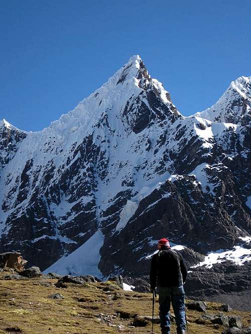
![Machu Picchu]() Machu Picchu, with Cerro Huayna Picchu in the background
Machu Picchu, with Cerro Huayna Picchu in the background
A much bigger hill right next to the site is Cerro Machu Picchu. I didn't know if there would be any red tape for that as well, but being a 1.5 hour hike up, I didn't expected all that many enthusiasts. And, last but not least, close to Aguas Calientes and just east of Machu Picchu is Putucusi, highly recommended in the Lonely Planet guide ("allow three hours"). That settled it. I would travel there early enough climb Putucusi in the afternoon of my arrival, and go see the ruins the day after. Yesterday, Iván had introduced me to his friend Nanci, who ran her own small travel agency. I stopped by her office today, explained my wishes – just transportation and basic accommodation in Aguas Calientes aka Machu Picchu village please – and left the rest for her to work out.
![Pachanta from the southeast]() Hiking in the Cordillera Vilcanota
Hiking in the Cordillera Vilcanota
I turned in early that evening. While my hotel was a step down from Casa de Melgar in Arequipa, it wasn't bad. The bed was soft, and the shower had an endless supply of hot water.
Broken ladders
Serving breakfast takes forever, and then I learn that there is a limit of no more than two rolls! I decide that when I get back here I'll get a room without it; I'll make my own. Besides, I'll be flying soon and I'm way over the luggage weight allowance, so eating some of my own supplies will help.
Shortly after ten o'clock Nanci collects me at my hotel, and we walk the few blocks to the departure point of the minibuses to Ollantaytambo, or Ollanta as most people call it, the end of the road in the sacred valley. I must still be tired, because I doze off a few times during the ride. From Ollanta, the voyage continues by train. Alongside the steep valley walls we catch glimpses of the glaciers on some of the high peaks of the Cordillera Urubamba and I have no trouble keeping my eyes open now.
Half past two the train arrives in Aguas Calientes, where, to my surprise, I'm picked up at the station. Together we walk to my simple hotel. As I would learn later, I should have paid a bit more attention to where we were going.
The guy who picks me up at the train station says that the track to Putucusi is out of order, but if I wish, I can have a look for myself. Sure, of course I wish! I drop off my gear and before long I'm on my way again.
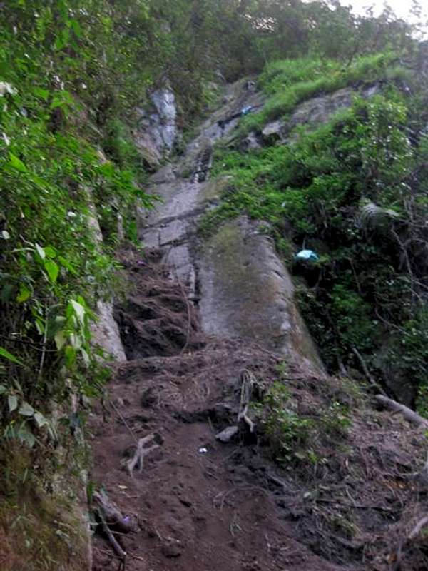
The lush vegetation is trying to overgrow the trailhead, but I know where to look and have no trouble finding it. After gaining some 100 m in altitude the trail arrives at a steep section. The Lonely Planet guide had predicted there would be ladders along the route, and as a matter of fact I had already passed a few. However, apart from some wooden remains, at this point there is nothing but a thick steel cable hanging down. After having a good look, I start climbing the rocks with the help of the steel cable and, occasionally, the broken parts of the ladders. Carefully I work my way up. It is steep and somewhat wet, and without the cable it wouldn't be possible. This section must have been why the man said that I couldn't go up Putucusi. And for hikers, sure, the track is impassable, but with good balance and a good head for heights it's not too bad.
According to my altimeter, it is 503m from the start of the track to the top. The first part of the route is actually on a different mountain, connected to Putucusi by a saddle around 280m below the summit; Putucusi itself is too steep for hiking trails lower down. The lower part is in a lush, thick forest, but from the saddle upwards the vegetation is not quite as dense, and you can see the summit. Once you're there, you can enjoy striking views of Machu Picchu as your reward. Unfortunately, late in the day I'm staring into the sun, which makes it hard to get good pictures. I reckon the best time for that would be early in the morning. But I won't come back here; I have other plans for tomorrow.
![Jungle flower on Putucusi]() Jungle flower
Jungle flower
On my way down, between the saddle and the broken ladders, I'm surprised to meet someone else on the trail. His name is Johnno. He and a friend had simply happened to see the trailhead and wondered where it would lead to. I tell him he still has 300m to go ascend, without serious difficulties, but there isn't enough daylight left for it. It's already approaching five o'clock, and sunset would be in half an hour or so. Nevertheless he continues up, as I go down. After carefully descending along the steel cable, I join Johnno's friend. He had started climbing the cable too, but then decided he didn't like it and is waiting for his buddy now. A few minutes later, Johnno comes down too. Perhaps he had gone to the saddle, seen how far he still had to go and turned back.
I leave them behind and hike back to town. I get there around half past five, but the walls of the sacred valley are steep, and you don't really see the sunset. It just gets dark, quickly.
I follow the Lonely Planet guide again, this time for dinner advice. I chose Indio Feliz, and I wholeheartedly recommend it; the food is outstanding!
It's too early
I had set my alarms – cell phone and wrist watch – at 4:10 and 4:15, but when they went off, I didn't feel like getting up yet and turned around in my bed. Two hours later I woke up again, feeling a lot better. Just past seven I was on the move. While it had not been a conscious decision, it proved that I simply was not motivated enough to climb Huayna Picchu to sacrifice a few hours of sleep for it.
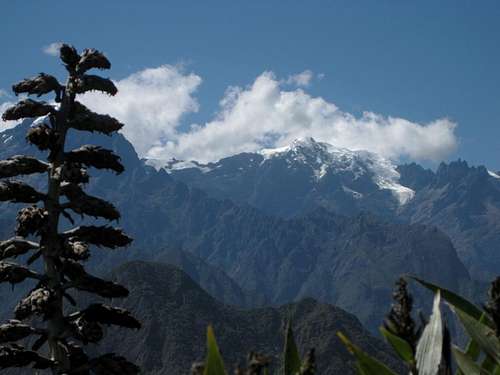
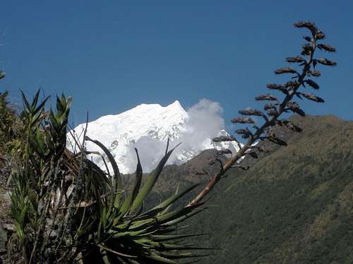
![Putucusi from Machu Picchu]() Putucusi
PutucusiIn the beginning, walking to Machu Picchu meant following the same road as the shuttle buses. I didn't find it particularly interesting. Fortunately, after the inauspicious start, it soon got better. A steep footpath worked its way up the slopes, crossing the road every so often. The trail leads through the lush forest, with plenty of views into the sacred valley below, and to Putucusi on the other side. And there were lots of flowers that I had never seen before.
It took an hour and a half to get to the entrance of Machu Picchu. I had expected a line, but I could go right in. Since I had read that taking food into Machu Picchu is not allowed, I had polished off all my fruit before entering. Later I saw people eating all over the place, so apparently the rule is not enforced rigorously. Pity, because where people eat, they often leave traces, and it was no different here. Not a good job by the authorities responsible for the preservation of Machu Picchu for future generations.
I explored the ruins for a couple of hours. There were plenty of guided groups as well as people on their own, but it wasn't crowded. It was pretty impressive, but, to be honest, the hike up to Cerro Machu Picchu was the best part. Granted, having great views down to Machu Picchu had something to do with that, but, at least as good, higher up, the distant glaciated mountain tops of the Cordilleras Urubamba and Vilcanota came into view. I never get bored by a sight like that. Maybe I'll come back and climb them someday.
I hiked down to Aguas Calientes pretty fast. I had to, because I had a train to catch, but after picking up my luggage at my hotel it turned out to be a challenge to find the station again. I should have paid more attention yesterday. Nowhere did I see a sign and, sure enough, I took a wrong turn. The town is not big enough to get lost though, and I quickly realized my mistake. I caught my train just in time.
The 'Vistadrome', as it was called, was rather different from my ride in. To my surprise, the staff put on a show. It was a mix of folklore and fashion show with the obligatory items made of alpaca and vicuña wool. It was well executed, humorously and stylish. Whether anybody actually bought something, I don't know, but if not, the presentation was not to blame.
At dusk the train reached Ollanta. Nobody was waiting for me this time. I dug up my cell phone and saw that I had missed a couple of calls. I was just about to call myself, when the phone rang. It was Nanci. There was a problem, so my planned ride was not there; could I take another one? "Sure", I said, because several drivers had already offered their services.
Shortly after arriving at my hotel in Cuzco, she dropped by to explain what had gone wrong, and to return some money – for the transport, and because my hotel in Aguas Clientes was not 30 US $ but only 30 soles – which I hadn't even noticed. It's always nice to meet honest people. We went out for dinner together, and it got rather late.
Traveling
I had breakfast in my room, eating from my own supplies, and with some fresh rolls of great tasting
pan integral at a small local bakery-slash-coffee shop (the real deal, not the type you'll find in Amsterdam).
Well ahead of time I was at the airport. At check-in my big bag was 2 kg over the limit, but it got waved through. With my also way too heavy small bag, and all my pockets full of stuff, I passed more checkpoints. The final one before the gate brought a surprise. There was an X-ray machine, so I put the bag on the conveyor and emptied all my pockets. At the other side someone asked who the owner of that red bag was? Well, that was mine.
The machine had shown my climbing ropes in there, and the officer said that that was not allowed. He took them out of the bag and set them aside. Obviously, that didn't make me happy, nor did I understand the reason why. That made me nervous. What rule might there be against climbing ropes in hand luggage? And if they were not allowed, could I then please check them in? That would cost me all right, since my ticket only allowed one piece of check-in luggage and I was over the limit already, but they were far too expensive to leave behind.
He told me to wait.
I wondered why. I couldn't do anything while I waited, but figured that I wouldn't want to fly without my ropes; I would rather suffer the long bus ride instead. Ten minutes later he grabbed the ropes and asked me to follow him. He went around the corner, to a quiet place, and said I could take the ropes back to the check-in counter if I gave him 20 soles (7 $). My smallest bill was 50. Obviously he didn't give me any change, let alone a receipt. I didn't have time to argue, I had to rush back to the LAN counter now. Fortunately, Cuzco airport is small. Still, all this brought me back at the counter pretty late, with extra luggage. But luck was on my side now. I guess they must have thought that the sooner I would be back at the gate, the better, or the flight might get delayed, for they quickly slapped a label on my ropes and sent me on my way, without charging me for the excess weight.
The message I received a few weeks after my complaint
We are writing to inform you, on behalf of tourist information and assistance; that after sending a letter to CORPAC Cusco, explaining the details about your claim; we have received their argument on June 22nd, 2011.
In the argument they apologize for all the inconveniences, they explained that after the investigations, they haven't identify the people that asked you for the money, however they have decided to fire a group of people who worked the day of the happening.
We appreciate your attention and if you have any consult, do not hesitate to contact us.
Without further incident I arrived in Lima. I had ample time to catch the night bus to Huaraz, and that would eventually mean bad luck for the corrupt officer. At first I went to the LAN counter to make some enquiries. I learned that there was indeed a rule against ropes in hand luggage, but that was not the end of it. They directed me to a counter for travelers with complaints, where I filled out a form with my experience at Cuzco airport. Not that I expected to ever see my money back, it's just that I hate corruption. In fact, I didn't expect to hear anything about it anymore, but a few weeks later I got an e-mail: as a result of my complaint, people had been fired! Perhaps my experience was not the first one, or the reaction would be rather over the top. But I like to think that Peru is a fraction less corrupt now.
Nevertheless, I still don't have a clue why ropes should not be allowed as hand luggage...
Huaraz
The night bus to Huaraz turned out to be very comfortable. It had plenty of leg room, and the seats reclined very far. It was a big difference with the one I had been on two weeks before, from Arequipa to Cuzco. I slept like a baby this time!
When I woke up, it was light already and we were driving in the streets of Huaraz. Minutes later we arrived at the terminal. I selected a place to stay close to the bus station, Aldo's guest house, simply so I wouldn't have to carry all my belongings too far.
After dropping my stuff, I checked out the town. I put up notes at various places, stating that I was looking for climbing partners. The Casa de Guías turned out to be closed – it was a Sunday.
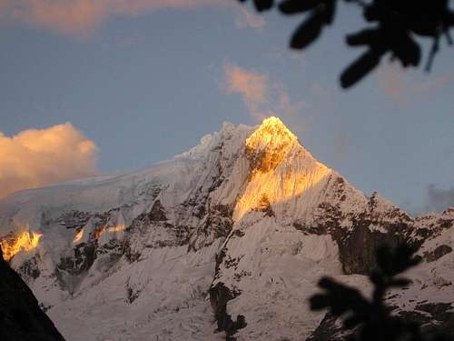
![Sunset on Vallunaraju]() Vallunaraju from Huaraz
Vallunaraju from HuarazOne of the places I visited was Edward's Inn. A friendly guy opened the door and welcomed me. It was Edward, the owner of the place and until recently an active mountain guide himself. Now he was tending to his hotel business, but he still knew the mountains very well. We talked, and I concluded that Urus, Ishinca and Pisco would all be potential future solo objectives, but for my first climb, I settled on Vallunaraju (5686m): it was climbed often, so there should be a clear trail on the glacier, which wouldn't be heavily crevassed. The base of the mountain was easy to reach by taxi, and I could then make my way to the summit early the next day. There might be a refuge under construction at the end of the road, but if I wanted to know more about that, I should ask at the Casa de Guías tomorrow.
The best book for climbing in the Cordillera Blanca is the one by Brad Johnson
[2]. I brought it from Amsterdam, but you can buy it all over Huaraz. The book doesn't cover everything, but still quite a lot. For Vallunaraju, unfortunately, it only describes the North ridge route, while the normal route is more or less from the south. But I had a map
[3], a few simple directions, and expected a trail to follow once I would reach the glacier.
Off route
The next day, Casa de Guías would open at 9:30. That was too late; I didn't want to wait so I would forego that.
At the National Park office, I bought a ticket to visit the park, and filled out some paperwork to obtain a permit to climb Vallunaraju unguided. The people at the office were friendly and helpful. The permit was free, but I had to show my alpine club membership card to get it: it's considered proof that you know what you're doing. A scary thought, if you think about it, but at least it prevents the totally unprepared from getting in trouble.
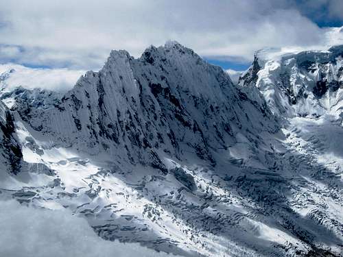
![Ranrapalca]() Ranrapalca from Quebrada Llaca
Ranrapalca from Quebrada Llaca![Lupine and Ranrapalca]() A lupine along the trail, with Ranrapalca in the background
A lupine along the trail, with Ranrapalca in the backgroundSomewhere along the road to the Llaca valley, not far from the mountain, my taxi was stopped. Someone, presumably a park ranger, asked to see my passport, park ticket and climbing permit. He studied it closely, but found everything in order and sent us on our way again.
![The southern edge of the glacier on Vallunaraju]() The edge of the glacier
The edge of the glacier
The Llaca valley is dominated by the steep walls of Ranrapalca. It didn't look easy or safe to climb, just beautiful. The refuge was indeed under construction. There were some tents around, but there was still plenty of daylight. It was impossible to miss the obvious trailhead, a few hundred meters before the end of the road, so I started making my way up the mountain. There are small trees, shrubs and flowers along the trail.
After hiking and scrambling up a few hundred meters on the steep slopes, the terrain levels out somewhat. So far, the clear trail through the shrubs has been easy to follow, but now it continues on slabs. There are plenty of cairns marking the way, until shortly before I reach the edge of the glacier, at around 5000m. There are some flat spaces on big rocky slabs, and there is running water, so I could camp here, but I see no trail ascending the glacier anywhere, and there is only steep ice to get on it. This doesn't look like the normal route to me, but I see no cairns anymore either.
![Slabs on Vallunaraju]() Slabs
Slabs
I decide to follow the edge of the glacier, staying on the slabs, and head towards the south west. The slabs are not difficult to negotiate, but I don't see any signs of a trail or a camp site for quite a while. I lose a little bit of height. Eventually I spot a couple of small lakes further down, and what looks like a small tent on the far shore of the closest one. According to my map there are a few lakes at 4606m. As I work my way down to the nearest lake, the slabs get steeper and steeper. At one point I start feeling a bit uncomfortable, clinging to the rocks. I mean, the climbing is not too difficult, but here I am, soloing somewhere off the normal route, and all that keeps me from falling off these slabs is the friction of my boots. I don't have any margin for error and there won't be anybody coming along soon in case I have an accident and need help.
I unstrap my big pack and let gravity take over. It slides and tumbles some 30 meters before it stops. I'm glad that that wasn't me falling down! It looks like it has ended up in a wet spot, but I'll deal with that later. Right now I must make sure that I get down safely, preferably much slower than my pack. However, my decision proves to be a good one. Without the heavy weight on my back it's much easier. I'm focused, making sure I don't make a mistake. Before long I rejoin my pack. Even before reaching the lake, I find a big flat spot, with running water almost next to it, and put up my tent.
Looking at the terrain, and judging by my altimeter, these lakes can't be the ones on my map though. And when I check later, I find they are clearly visible with Google satellite view, and lie between 4800 and 4900m.
When I unpack, everything still seems to be dry. My pots and stove have a few new dents to show for the experience, but when I light it, it still works. No harm done.
![A tranquil lake south of Vallunaraju]() A tranquil lake, early next morning
A tranquil lake, early next morning
|
Success
I did it! In five hours I had reached the top! My first summit in the Cordillera Blanca!
![The two small glacial lakes south of Vallunaraju]() Looking down from the saddle
Looking down from the saddleI had not left early that morning. Being alone, I wanted to see what I was doing, so an alpine start was out of the question. At first, below the glacier, there was a trail of sorts. It aimed at a saddle, north by northwest of my camp site. A bit higher up, in a boulder field, the trail faded. I saw a large strangely shaped boulder – would that perhaps be a cairn? A bit of easy scrambling brought me up there, but no, it was a natural shape, not a cairn.
Now that I'm here, it looks like I can easily make my way upwards, trail or no trail. Soon after I reach the glacier. The terrain is not steep at all. I follow the border between ice and rocks for a while, and, sure enough, before long I come across tracks leading up onto the glacier. Made by one person, by the looks of it. I follow it on ice and hard snow. Soon it gets steeper and I have to put on my crampons. And then the trail suddenly ends! From what I know, and looking at the map, the normal route must be somewhere further north, so that's where I go. And indeed, without trouble I soon pick up a trail again.
Then I spot two descending climbers in the distance. It's still early. If they've been to the summit, they must have started well before sunrise. However, before our paths cross, they go down a different way. Apparently my trail isn't the normal route yet. And that's how I learn that the normal route does not start at the south end of the glacier, which is what I had been doing, but comes from the south east.
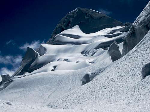
![Big cornice high on Vallunaraju]() Ice
Ice![Climbers descending Vallunaraju]() Climbers descending
Climbers descendingNow that I'm finally on the normal route, I have a trail as big as a highway to follow. Going up, I meet several guided parties coming down.
Twice I have to cross a not particularly wide crevasse with a snow bridge. I don't test them but simply step straight over to the other side.
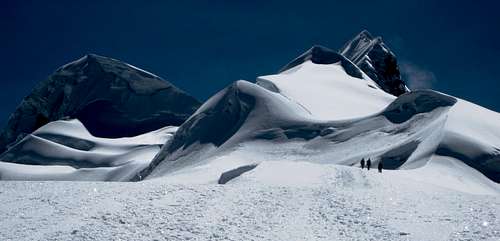
![Vallunaraju Sur]() The south summit
The south summit![That looks like a big cornice on the summit of Vallunaraju]() Fortunately, the true summit is just a bit further back, and a lot safer to reach. If you look closely, you can see the trail go to the lowest point on the ridge, well right of center. After crossing the bergschrund and a very short steep section, the trail continues on the other side of the ridge, exposed, but at a safe distance from the dangerous drop.
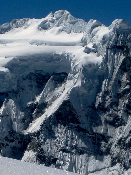
Fortunately, the true summit is just a bit further back, and a lot safer to reach. If you look closely, you can see the trail go to the lowest point on the ridge, well right of center. After crossing the bergschrund and a very short steep section, the trail continues on the other side of the ridge, exposed, but at a safe distance from the dangerous drop.![Ice sculpture on Vallunaraju]() A glacier with a bite
A glacier with a bite
As I had seen clearly yesterday, from downtown Huaraz, Vallunaraju has two summits. The route passes by the lower south summit to the saddle. There is a short steep section here, immediately followed by an exposed ridge. For a moment I think it leads to the summit, but it's only a false one. However, the true one is only minutes away, and for the last section the trail gets much wider again.
Right after I arrive on the summit, the clouds start to move in. I barely have time to take a couple of pictures of the steep faces of Ocshapalca and Ranrapalca before I find myself in a whiteout. A pity for the views, but apart from that it's no problem. The trail is so obvious, I won't need more than one meter of visibility. The only tricky bit might be where I would have to turn right, the point where I had joined the main trail lower on the glacier.
Luckily the clouds only cover the very top of the mountain. Even a little bit lower, visibility gets fine once more. And during my descent, off and on the twin summits of Vallunaraju come into view again. Getting back to my tent takes no time at all. Sure, the snow is somewhat softer now, but only the top layer and that doesn't slow me down.
Early in the morning, after drinking a lot at breakfast, I had started out without water, so by the time I got back to my tent, rehydrating was my top priority. Although by now it wasn't particularly early anymore, after eating a bit, I decided to pack up camp and start my descent. I wasn't expecting to make it to Huaraz, but if I could camp by the road, I could catch a ride early tomorrow. By four o'clock I was on the move again.
Being off the normal route, I had to find my own way. Instead of climbing back up the slabs from where I came, I hiked around the lake – and as I passed what I had yesterday mistaken for a tent, I saw it was only a big rock! There were traces of a trail, which I followed, but it faded away. The rugged, undulating terrain was covered with a mix of rocks, tussock grass and low shrubs. The vegetation wasn't really dense though, so I just traversed the mountain to the north, staying well below the slabs, in the knowledge that I had to cross the regular trail sooner or later.
Although I couldn't see the lower part of it, I spotted a couloir that I thought I could descend. It wasn't where I had come up, but it would certainly be shorter. At first, the going was easy, but it got steeper and steeper. Realizing that it had become too dangerous, I was forced to scramble back up again.
Somewhat further north I saw another steep gully that looked good – but history repeated itself, as lower down once more I didn't like what I saw. My attempts to get down quickly had backfired, and I had only been wasting time and energy. By now the sun was about to go under.
![Sunset on Ranrapalca]() Alpenglow on Ranrapalca
Alpenglow on RanrapalcaAs I knew, it was a full moon tonight. That definitely helped a lot. To avoid tripping, I switched on my headlight when it got dark, so I could see what was right in front of me. Even after sunset, I tried to descend another couloir. Soon I wasn't hiking anymore, I was climbing down. The final straw came when a rock came loose and fell away from under my feet. That's it, I thought, this is too dangerous, and I made my way back up again, to where the slopes were gentler.
Instead of getting off the mountain, all I wanted now was simply to find a place to spend the night. There were plenty of small streams, so water wasn't the problem, but although the terrain wasn't steep, it was not exactly flat either, and there are shrubs all over the place. I was tired by now, and quite slow, especially when I had to go up. However, I wasn't tired enough yet to simply roll out my sleeping bag; I still wanted a spot to put up my tent.
I resorted to traversing the slopes once more. I figured that eventually I had to come across the trail – or did I already miss it somehow? In the mean time I kept an eye out for a place to camp. And then, finally, I found the trail. I still had no place to camp, but I could follow the trail down this time, much faster than going cross country, and I could put up my tent when I would get down to the valley.
But I got a second lucky break: there was a clear flat spot, just big enough for my tent, right next to the trail! And as if that wasn't enough, minutes earlier I had passed a small stream. After a late dinner, I finally hit the sack just after midnight.
Back to civilization
![Camping on the slopes of Vallunaraju]() Camping on the slopes of Vallunaraju
Camping on the slopes of VallunarajuI slept in late today and that sure felt good after yesterday's trials and tribulations. I didn't start walking until around ten o'clock. After descending no more than 250 m, I got a surprise: I had to get down a steep rocky section. Sure, I had come up this way two days ago, but going down is a different matter!
![Quebrada Llaca]() Quebrada Llaca
Quebrada Llaca
I lowered my backpack on a piece of cord. It wasn't long enough, so my pack had to suffer another tumble. As I down climbed after it, it proved to be easier than it looked. Mostly it was climbing by friction, trusting my soles again. But I certainly was happy that I didn't have to do that by moonlight! A little bit lower another, easier scrambling section followed and soon after I reached the road in the Llaca valley. I started walking towards Huaraz, but didn't have to go far before I got a ride back to town.
Back in civilization, the place where I had stayed before was full. I didn't mind; I gathered all my belongings and took a taxi to Edwards Inn. There were plenty of free rooms. Edward runs a simple but clean hotel, mostly with hot water. The greatest asset of the place is Edward himself though. He knows the mountains very well and is enormously helpful. In the coming months, I would keep coming back to stay there and ask his advice on whatever adventure I was planning next. And his mom bakes mean pancakes in the morning!
The story continues here: Stumbling through the mountains, dental problems and visiting the local hospital
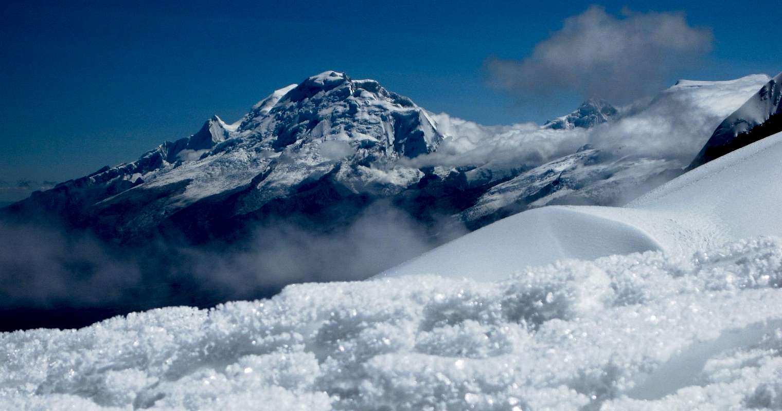
![]()
Huascarán from Vallunaraju. I'm enjoying the view, but in the back of my mind I'm hoping to get a chance to climb it later...
Books and maps
[1] Lonely Planet guide Peru, 7th edition, 2010, ISBN 978-1-74179-014-6.
[2] Classic Climbs of the Cordillera Blanca, Brad Johnson, 2009 revised edition, ISBN 978-0-9758606-1-8.
[3] Alpenvereinskarte Cordillera Blanca Süd (Perú), 2005, ISBN 3-937530-05-3.


Comments
Post a Comment