
|
|
Mountain/Rock |
|---|---|
|
|
38.66120°N / 119.898°W |
|
|
9415 ft / 2870 m |
|
|
Overview
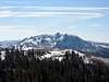
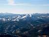
Markleeville is not the busiest peak as its higher neighbour Round Top sees much more visitors. This is hard to understand as Markleeville Peak is a fine peak in itself and also offers nice views of its surroundings. The approach to the mountain is straightforward because just a couple of years ago, the Blue Lakes Road was paved. Markleeville Peak also make for a nice winter snowshoeing adventure.
 |  |  |  |
Getting There
This mountain can be climbed from almost all sides. A western approach from the Blue Lakes Road allows for the shortest climb. From the intersection of CA-89 and CA-88 in the Hope's Valley (Pickett's Corner) head west on 88 for about 3 miles until the turn-off onto Blue Lakes Road to your left. Follow the road for about 7 miles until you are straight west of the southern ridge of the mountain. Start your hike here and gain the ridge before you head north up to the highpoint. This is the southern approach. For an approach from the north, follow Blue Lakes Road for 6.5 miles unti an old looging road turns of on your left hand side. Follow that road, which after less than a mile will fork off as a pack trail to your left and continue as logging road up the mountain. After another 0.5 miles or so leave the road and head south straight up to the obvious ridgeline. From the ridge you can easily gain the summit to the east.
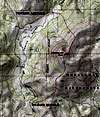
See map of these two approaches in the "photo" section of this page.
Another way to climb this mountain is from the Grover Hot Springs State Park (see routes for the description).
 |
Red Tape
In the winter you need a California Snow-Park pass to park at the Hope Valley Snow Park (Nov-May). The cost for the pass is $5 for a day and $25 for the season. It is good to get a season pass because it allows you to park at many other trail heads in the area. Places that are close by that sell them are the Shell station in Meyers and the the Kirkwood gas station. Check the Snow Park website for more information. In the summer you can park for free. This peak lies in National Forest Land so a permit is not needed.
When To Climb
The mountain can be climbed all year around. However, the approach is much longer in the season as Blue Lakes Road is closed and one has to park at the Snow Park lot. Also in the winter, when you snowshoe on or along Blue Lakes Road, watch out for snowmobiles.
Camping
The Eldorado National Forest's website has good information on camping.
Mountain Conditions
Check the Eldorado National Forest for
For latest information on avalanche conditions go here.
For a forecast of the greater Lake Tahoe area, consult this page.