
|
|
Mountain/Rock |
|---|---|
|
|
41.86855°N / 115.84082°W |
|
|
Elko |
|
|
8792 ft / 2680 m |
|
|
Overview


East of Mountain City in remote northeastern Nevada lies the Bruneau Range, also known as The Mahoganies, a minor range that trends southwest to northeast for about 17 miles. Merritt Mountain, with an elevation of 8,792 feet, is the range high point. With a prominence of 2,372 feet, Merritt ranks #119 on Nevada’s list of 172 prominence peaks. The naming of this peak is unknown to me – if someone could shed some light on it, I’d sure appreciate you dropping me a message.
The toughest part of Merritt Mountain is the drive in. Just south of the summit are Points 8,768 and 8,754, the latter of which has two small antenna arrays and support structures which are visible from the access road far below. What makes the drive a bear is not the condition of the road, which does have some areas where high clearance is a must and maybe a couple of spots where you’ll need 4WD, but overall is not too bad. There was a stretch of 2 miles or so where the going was very slow due to the large number of cattle on or near the road. (more on this under “Getting There”) The vegetation growth on the sides of the road that made for narrow passage in some areas only exacerbated the situation. As careful as I was, I still nearly hit a calf that jumped into the road in front of me.
Considering that a road leads close to the summit, I had a hard time believing that Merritt’s most recent visitor was more than four years ago – that was John Vitz in June 2006. During that visit, John placed a makeshift summit register to replace the existing one that now has fungus growing on the register inside the jar, and probably did in 2006. According to John’s entry in the new register, someone had previously placed the other jar upside down, allowing moisture intrusion. So there are now two jars and registers on the summit. I had a heck of a time getting the lid off of the jar, and that might explain the shortage of entries in the register. Though tempted to peek at the other register, I decided to leave well enough alone.
There are nice all-around views from the top of remote Nevada, most notably the views to the northeast into Idaho of Bruneau Canyon and to the east of the Jarbidge Mountains that tower over the small mountain town of Jarbidge.
 Summit view to NW. Summit view to NW. |
 Summit view to NE. Summit view to NE. |
 Summit view to E. Summit view to E. |
Getting There
One mile south of Mountain City on NV-225 (Mountain City Highway), turn onto the Forest Service Road and head east. After about 3.8 miles, take the 4WD that veers to the left – you’ll see a #33 marker at this intersection with a #934 sign to the left of it. This road will continue east for another 5 miles before curving left and heading north, where you’ll see a gate after about 1.5 miles after the road curves to the north. After about 3.5 miles on the 4WD, I started seeing a lot of open range cattle milling about on and near the road; this continued for 2+ miles. I mention this to emphasize that you have to take extra precautions when driving in areas like this, especially where you can’t see beyond the curves of the road. After passing through the gate, it’s another 2.5 miles to the terminus of the road near the radio facility. You can stop at any point along the road south of Merritt’s summit and it’s just a quick trip to the top. Although there is no trail, the route is very obvious and easy. If you choose to park at the end of the road, it’s still only 0.6 miles one-way to the summit. Round-trip gross elevation gain is 270 feet (150 feet on ascent, 120 feet on descent) from this point.This route is almost entirely on USFS-managed lands.
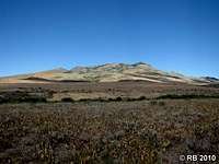 Merritt from access road. Merritt from access road. |
 Open range. Open range. |
 Narrow section. Narrow section. |
 Patsville.
As a possible side trip, you could visit the ghost town site of Patsville, just 1 mile south of the Forest Service Road turnoff from NV-225. As with so many Western ghost towns, Patsville began and ended with mining. Patsville had only a brief existence, beginning in 1932 and ending in 1949 after the nearby Rio Tinto Mine played out.
Please refer to the below maps for the driving route.
 Route map 1 of 4. Route map 1 of 4. |
 Route map 2 of 4. Route map 2 of 4. |
 Route map 3 of 4. Route map 3 of 4. |
 Route map 4 of 4. Route map 4 of 4. |
Maps
BLM Surface Management Status Quad (1:100K scale) – Jarbidge MountainsOrder through BLM at 775-753-0200 or online