
|
|
Mountain/Rock |
|---|---|
|
|
48.71010°N / 117.2867°W |
|
|
6784 ft / 2068 m |
|
|
Overview
Now close your eyes and spell the name of this mountain. Did you screw it up?Molybdenite Mountain: easy to say, hard to spell.
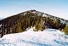
Molybdenite Mountain is located in the northeastern corner of Washington in the Selkirk Mountains. It is a sprawling mountain trending East-West with four distinct tops, the highest of which is at the west end. If you look on a Washington gazetteer map its location immediately jumps off of the page. The highest point is 10 miles west of the Idaho border and 18 miles south of the Canadian border. The highpoint ranks 96th in prominence in the state (2344P). The next-higher peak (the peak that "holds its prominence") is 6,880+ ft Salmo Mountain 17 miles to the NNE (see this picture). The Noah's Saddle from which Molybdenite's prominence is calculated is 5 miles to the ENE on the Harvey Creek-Granite Creek Divide.
Much of the lower flanks of the mountain have been logged. The associated logging roads allow for close approaches but, thankfully, the summit ridge appears to have been left alone. There aren't many peaks in NE Washington that would qualify (in my opinion) for inclusion on summitpost. The major ones (Gypsy Peak and Abercrombie Mountain) have already been added only because they are also county highpoints. Otherwise, they too might have been neglected. Although, Gypsy resides within a wilderness and Abercrombie is a large mountain with very large prominence. Molybdenite's highpoint West Summit once had a lookout at its top. Now all that remains are a few beams and the rusted Osborne Firefinder platform. There are also two poles with odd contraptions at their tops. I'm not sure what they were (may have been riblets for a tramway). Was there a molybdenite mine at or near the summit? I saw no evidence of such but there was snow on the ground.
 |  |  |  |
What is Molybdenite?
I checked the USGS database and there is only one mountain with molybdenite in the name in the United States. (There is also a Molybdenite Creek in the Toiyabe National Forest of North-Central California.) What is molybdenite? Molybdenite is a mineral also known as molybdenum disulfide. It has a blue-gray metallic luster and its texture is greasy. One of its major uses is as an ingredient in lubricants--especially for aircraft engines. Mines for it in the U.S. can be found in Utah, New Mexico, and Arizona. Everything you wanted to know about molybdenite can be learned here and here is a picture of what it looks like.
Getting There
There is a sturdy logging road that runs all the way around the south, west, and northwest sides of the peak. In summer, this road will allow for the closest approach to the west end of the massif. In winter or spring you may have to walk this road from a lower elevation depending on where the snowline is. A trail apparently ascends to the West Summit from the northwest. I did not see this trail (I climbed up the south side). There is also apparently a trail that runs east to west along the entire length of the mountain. This trail would offer a pleasant alpine and sub-alpine mosey but the distance to the highest point at the western end will be more than 6 miles compared to 2 or 3 from the westside road. To get to the logging road in question the first order of business is to get yourself on the correct (east) side of the Pend Oreille River, which runs past the west side of the peak. Bridges across the river are not everywhere.If you will be coming from the south (like from Spokane or Newport), the first and best crossing is at Usk 26 miles south of Molybdenite. Consult a map for more information. Once across the river at Usk, drive north on Le Clerc Creek Road (through the Kalispel Indian Reservation). In about 20 miles from the river crossing, just north of where the river makes a distinct bite to the east, East Fork Le Clerc Creek Road junctions off and extends up the East Branch of Le Clerc Creek. In 0.9 miles go right at the wye and in another 4.3 miles go leftonto FR-1936 at the next wye. In another 7.5 miles is the junction of FR-1936 and FR-1935. FR-1936 is the one that extends all the way around the west side of the peak. FR-1935 extends all the way around the east side of the peak. The latter is used to access the ridge crest trail, which starts near here (c. 5,100 ft) about where the road nearly crosses the divide.
If you will be coming from the west or north, drive the highways to the bridge crossing just southeast of the town of Ione. Once across the bridge, continue east on Sullivan Lake Road for about 6 miles to a junction on the right (2,852 ft). This is the northern terminus of FR-1936 (or it might be signed "FR-1933: West Branch Le Clerc Creek Road". Drive this road up the hill for about 0.6 miles to a 4-way junction (might not quite be a 4-way; the left and right turns might be staggered). Go left (east) onto FR-1936. Follow FR-1936 up and around toward Molybdenite. If you follow it around far enough you will come to the FR-1935 junction described in the previous paragraph. Also, if you wish to do the ridge crest trail off of FR-1935 (see previous paragraph) you can get to it quicker from this approach by continuing east up Sullivan Lake Road for about 1.9 miles to where the northern terminus of FR-1935 junctions on the right.
 |  |
Routes
If coming from the south, you can drive FR-1936 to here (5,004 ft) where the road turns sharply at a saddle. The summit is only 2 miles from here. Hike ENE for a few hundred yards along an abandoned road or in woods to the 5,100-ft saddle between Tioga Creek and White Man Creek. You may see a lot of flagging or a thin swath cut through the small trees. This is the National Forest Boundary. Look close and you will locate survey plates on trees. A major logging operation has added roads in this area and there is a junction at this saddle. You can then continue WNW up the obvious road or go straight north cross-country. Eventually (at about 5,500 ft) the roads come to an end and the travel becomes easy semi-open forest then sub-alpine hiking.Time on foot = 2 hours; Gain = 1,800 ft.
If coming from the west or north, you can continue all the way around on FR-1936 to the start-point described in the previous paragraph or you can choose a shorter route from the road north or northwest or west of the summit. The first possibility is from 5,000 ft here where the road crosses Paupae Creek. This crossing is about 1.2 miles north of the summit. You would need to hike initially west through forest to the North Ridge then follow it to the summit (2 hours). The next possibility is from 4,800 ft approximately here. This is where my Benchmark mapbook shows the beginning of a trail extending up to the summit. From here the gain and distance will be greater. The next possibility is from the west side of the summit wherever might look most feasible. FR-1936 tops out at 5,100 ft here. You could take the spur from there east toward the summit. I don't know the state of this road but I imagine even if it's overgrown it will still be viable. The summit is only a short distance away.
The ridge crest route from FR-1935 starts at about 5,100 ft here. My mapbook shows the trail extending up to the ridge then following it all the way to the West Summit. The terrain distance amounts to approximately 7 miles with the following total gain: +1300 -400 +400 -400 +600 -200 +700 = +2,000 net.
 |  |  |
Red Tape
There is no red tape that I can think of. The summit is within the Colville National Forest. Lower west and southern flanks are private timber land probably. I saw nary a gate.When To Climb
The main difficulty is access. In winter you will surely be stymied by snow over the roads far from the summer start points. In this case, probably the shortest route would be from Lake Sullivan Road on the north (there are farms up that road so it must be open year-round). In the spring the trilemma of snow and mud and muddy ruts will be your biggest stymie concern. There are plenty of trees (at least for the southern approach) to provide shade for lingering snow. In summer you should have no trouble getting to the regular start-points. Logging trucks should be heeded all year (mainly a weekday problem).Camping
Molybdenite Mountain can be climbed in half-a-day so there is no need to camp. If you must, there are plenty of creeks to feed your camel's back but the extreme upper slopes would probably be dry.Mountain Conditions
Ione weather forecast (nearest town)localized mountain forecast
Views from the Summit I
 |  |  |  |  |
Views from the Summit II
 |  |  |
External Links
- Bunchgrass Meadow automated weather sta.
The National Weather Service operates an automated observation station at Bunchgrass Meadow, located off the east end of Molybdenite Mountain. Located at elevation 5,000 feet, one can get real-time hourly observations of the mountain conditions. Equipment measures temperature, precipitation, snow depth, and more.
dluders - May 21, 2005 1:53 pm - Hasn't voted
Untitled CommentThe National Weather Service maintains an automated observation station at Bunchgrass Meadow, located just east of Molybdenite Mountain at elevation 5,000 feet. Click on this link for hourly observations (temperature, precip, snow depth, etc.): Bunchgrass Meadow .