
|
|
Mountain/Rock |
|---|---|
|
|
36.78511°N / 118.39888°W |
|
|
Fresno |
|
|
Spring, Summer, Fall |
|
|
12887 ft / 3928 m |
|
|
Overview
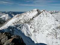
Mount Rixford is located in the middle of the Gardiner-Kearsarge Divide in Kings Canyon National Park, a scant eight tenths of a mile east of the popular John Muir and Pacific Crest Trails. The peak offers excellent views north into popular Rae Lakes basin, as well as to many other summits and lakes in the surrounding the area. Notable peaks visible from Mount Rixford include University Peak, Mount Tyndall, Mount Stanford, Mount Kaweah, Mount Brewer, Mount Clarence King, Split Mountain, and many others.Though Mount Rixford is only a short distance from Glen Pass (and the John Muir Trail) the west ridge involves some traversing over disagreeably loose rock, and it is far from the forefront of most JMT hikers’ objectives. Consequently most ascents of Mount Rixford are dayhikes or short overnight trips from nearby Onion Valley. Trips beginning in Onion Valley reach the summit from either the south slopes west of Kearsarge Pass or in connection with nearby Mount Gould via the east ridge.


Getting There
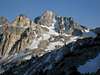
 Rixford from Mt Gould
 Route Map
Mount Rixford is best approached from Onion Valley in Inyo National Forest or Roads End in Kings Canyon National Park. Onion Valley is the easier, more scenic, and most popular option.
Onion Valley (36.77247° N, 118.34091° W)
Turn west off Highway 395 in the center of Independence onto Onion Valley Road (also labeled Market Street). Follow Onion Valley Road 13 paved miles to reach the trailhead at the end of the road.
Roads End (36.79616° N, 118.58342° W)
Turn east off Highway 99 in Fresno onto Highway 180 towards Kings Canyon National Park. Simply follow the highway 92 miles all the way to Roads End in the back of the canyon (37 miles past the park entrance). Take care not to miss the left turn 21 miles from Highway 99 to stay on 180. If coming from the south, Highway 180 is best reached by using Highway 137 or 198 to connect to Highway 63 northbound in Visalia.
Approaches
The routes to Mount Rixford include mostly class 1 travel with cross-country class 2 to 3 ascents to the summit. Mileages listed here are for the east ridge from Onion Valley and the south slopes from Roads End.| Route | Distance | Gain | Description |
|---|---|---|---|
| Onion Valley via Kearsarge Pass | 5.8 miles one-way | 4,400 feet +800 feet on return | This is the usual approach, as it involves the most on-trail travel, the shortest distance, and the highest trailhead. The scenery along this route is also varied and fantastic. The trail is well marked at the junctions encountered. From Onion Valley follow the trail over Kearsarge Pass. From Kearsarge Pass, either ascend the class 2 south ridge of Mount Gould to reach the east ridge connecting to Mount Rixford or continue on the trail with a slight descent to the south slopes above Bullfrog Lake. |
| Bubbs Creek Trail from Roads End | 14.8 miles one-way | 7,900 feet +0 feet on return | The route from Roads End is very straightforward, with no major obstacles and bridges over Woods Creek two miles into the route. The scenery is nice but not as spectacular as over Kearsarge Pass, however, as 10 miles of the route simply follows Bubbs Creek through a canyon from Kings Canyon to Vidette Meadow. Simply follow the signs to Bubbs Creek, pass Junction Meadow, and turn left (north) at Vidette Meadow onto the John Muir Trail. From the John Muir Trail you can turn towards Kearsarge Pass to reach the south slopes or continue to Glen Pass for the east ridge. |
Routes
The most common routes to the summit are listed here, although there are alternatives. The northeast and southwest sides of the peak have loose rock, with a few short, loose cliffs to manage on the southwest side (making the south slopes a preferred alternative). | South Slopes – Class 1-2 Ascend the broad southern slopes from just about anywhere above Bullfrog Lake. The travel is not difficult at all yet offers excellent views to the south, especially at sunset. Simply keep going up until you reach the summit. |
 | East Ridge – Class 2 This route is popular for those visitors also including a trip to Mount Gould on their visit. The route up Mount Gould from Kearsarge Pass is straightforward class 2 (with class 3 summit blocks). From Mount Gould first cross the summit plateau to the west and then follow the ridge towards Mount Rixford, bypassing the highpoint in between on the left. Keep to the south side of the ridge as necessary when difficulties arise. There are a few rock bands to cross mid-route, but nothing difficult. |
 | West Ridge – Class 3 This option is most likely to be used if completing a portion of the John Muir Trail over Glen Pass. From Glen Pass drop your pack and keep southwest of the nearest pinnacle over lose rock to a notch on the ridge west of Mount Rixford. Cross through the notch to a saddle and follow the straightforward moves up the west ridge to the summit. |
Red Tape
 Kearsarge Pass
Entrance Fees:
There are no fees if starting from the Onion Valley Trailhead in Inyo National Forest. Roads End lies in Sequoia National Park, however, and an entrance fee is required. The Sequoia and Kings Canyon fee page has full details.
Wilderness Permits:
No permits are required for day trips but overnight trips require one throughout the year. For trips out of Onion Valley in Inyo National Forest permits can be picked up at the White Mountain Ranger Station in Bishop or the Mt. Whitney Ranger Station in Lone Pine. Quotas are in place May 1 through November 1. Check the Inyo National Forest wilderness permit website for the most current information and reservation availability. There is a high quota for this trail, but reservations are still recommended as this is a popular PCT and JMT resupply point. In Kings Canyon National Park, the Bubbs Creek Trailhead has quota of 25 people per day in place from late May through late September each year. Outside the quota season permits can be self-issued anytime at the Roads End Permit Station, otherwise they must be obtained from the same location during open hours. Check the Sequoia and Kings Canyon permit page for full details on hours, the reservation process, and reservation availability.
Food Storage:
Bear canisters are required, both in Onion Valley and this area of Kings Canyon National Park. There are bear boxes in the area in Kings Canyon National Park, but they are for PCT and JMT through hikers only.
Campfires:
Fires are prohibited everywhere in Onion Valley and above 10,000 feet in Kings Canyon National Park. Vidette Meadow is at 9,500 feet.
| Inyo National Forest Wilderness Permit Office 351 Pacu Lane, Suite 200 Bishop, CA 93514 Wilderness Information Line: (760) 873-2485 Permit Reservation Line: (760) 873-2483 | Sequoia & Kings Canyon National Parks Office 47050 Generals Highway Three Rivers, California 93271 (559) 565-3341 |
When to Climb
The roads to the trailheads are not plowed in winter, consequently spring through fall are the most realistic times for a visit. In early season snow is present at higher elevations, but those familiar with snow conditions should not have any difficulties. If planning a winter ascent, Onion Valley would have the better approach.
 |
 |
 |
 |
 |
 |
Camping
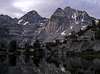
 Rae Lakes
Backcountry camping options are abundant at the many lakes or streams from either trailhead. Excellent options include Kearsarge Lakes, along Bubbs Creek, or the very popular (and crowded) Rae Lakes to the north, among many others.
Roadside camping is not allowed at Roads End, but dispersed camping is permitted not far away outside the park in Sequoia National Forest if approaching from the west. If starting in Onion Valley there are many scenic dispersed camping options along Onion Valley Road.
There is an established campground in Onion Valley, as well as Upper Grays Meadow and Lower Grays Meadow on Onion Valley Road. Reservations are available and recommended. The Inyo National Forest Camping page has further details.
In Kings Canyon there are four established camping locations (Sheep Creek, Sentinel, Canyon View, and Moraine) with over 300 total sites available. All but Sentinel are open on an as needed basis, making it sometimes difficult to spread out even when usage is low. Each campground has full amenities, costs $18/night, and all sites are first-come, first served. The Sequoia and Kings Canyon Campgrounds page also lists other sites in the area.