
-
 25301 Hits
-
 86.85% Score
-
 23 Votes
|
|
Mountain/Rock |
|---|---|
|
|
40.94503°N / 122.89925°W |
|
|
Trinity |
|
|
Hiking, Scrambling |
|
|
Summer |
|
|
8162 ft / 2488 m |
|
|
Overview
 Siligo Peak and Deer Lake from Deer Creek Pass
Providing some of the best views in the region for the least amount of effort, Siligo Peak is virtually unknown to all but the well-informed Trinity Alps enthusiast. A hike to the top and around the flanks of the mountain provide some of the most spectacular and memorable vistas anywhere in northern California. Views include the granite heart of the Trinity Alps, the Scott Mountains in the northern part of the range, the surrounding peaks of the Red Trinities, the Stuart Fork of the Trinity River and Deer Creek drainages, the southern Klamath Mountains, Mt. Shasta and Lassen Peak. All of this can be obtained by climbing the short but moderately steep southern flank of the peak, as well as hiking the spectacular Four Lakes Loop trail.
Siligo Peak, along with its neighbor Gibson Peak form a substantial granite intrusion into a region generally characterized by red serpentine and peridotite. The two mountains stand as sentinels over the upper reaches of Deer Creek Canyon. Four glacial cirques, oriented along the points of the compass, have been gouged into the sides of Siligo Peak. Each cirque contains an exquisite glacial lake. These four lakes form the core of the fantastic Four Lakes Loop.
Geography
 The Red Trinity Alps with Siligo Peak on the far left
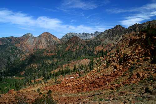
Siligo Peak is one of numerous summits in the Trinity Alps range of the Klamath Mountains. The Trinity Alps themselves can be divided into three distinct regions. In the west are the vast Green Trinities. This area is composed of steep canyons, roaring rivers, sharp ridgelines, and utter solitude. The "green" appellation is derived from the vast stands of virgin timber found in this area. The White Trinities, the granite core of the range is where the associate with the Alps is derived. This area occupies the center of the Trinity Alps. East of the granite heart of the range, rising above Trinity Lake, are the Red Trinities. The name comes from the color of the serpentine that composes most of the mountains in this section. Numerous excellent peaks over 8,000 feet as well as an enviable number of lake basins are found in the Red Trinities. While the Red Trinities are generally characterized by red serpentine and peridotite, there are numerous granite intrusions. Among the most notable are Siligo, Gibson and Granite Peaks.
Four Lakes Loop
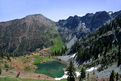
 Siligo Peak and Luella Lake
See the Four Lakes Loop page for more details.
Siligo Peak is the focal point of the Four Lakes Loop, one of the most scenic and interesting trails in the Trinity Alps. One has two options for getting to the beginning of the loop. The shortest route is to hike the Long Canyon trail to Bee Tree Pass and then traverse the base of Gibson Peak to Deer Creek Pass, where the loop begins. Long Canyon is a steep but spectacular trail with side trips possible to Bowerman Meadows and Anna and Billy-Be-Damned Lakes. The route passes through the upper stretch of Siligo Meadow just before reaching the Four Lakes Loop. Numerous excellent campsites are found in this area. This route is about seven miles.
The second option for getting to the loop is to hike up the Stoney Ridge trail to Stonewall Pass and then continuing through Van Matre Meadow, over Little Stonewall Pass and then through Siligo Meadow. One must climb once more up to Deer Creek Pass. The total distance for this route is 8 miles. Although this route is longer with a bit more climbing, it makes a better trip since one has a chance to climb Granite Peak, Red Mountain, and Middle Peak, as well as a chance to camp at Echo Lake.
 Seven Up and Gibson Peaks above Luella Lake
The Four Lakes Loop can be hiked either clockwise or counter clockwise. It makes no significant difference but I prefer clockwise since the descent into cirques containing Diamond and Luella Lakes are much more interesting from this direction. The loop is 5.2 miles long. From Deer Creek Pass, once traverses the Deer Lake cirque, climbing up to a saddle. One hikes north up the saddle to the top of Siligo Peak. Continuing the loop, Summit Lake becomes visible to the south, with Red Mountain looming in the distance. Eventually another saddle is reached and the Diamond Lake cirque spreads out to the north. The granite heart of the Trinity Alps rises dramatically to the west above the deep blue Diamond Lake. A short climb out of the cirque brings one to another saddle. The strikingly clear Luella Lake becomes visible, with Seven Up Peak and Gibson Peak towering across Deer Creek Canyon. The transition between the serpentine of Seven Up Peak and granite of Gibson Peak is a unique and interesting geologic phenomenon. From Luella Lake, the trail descends into Deer Creek Canyon and passes through the lush Deer Creek Meadow, with Gibson Peak a constant and impressive presence. A stiff climb leads out of the meadow and up to Deer Lake, which lies directly beneath Siligo Peak. Another climbs leads back up to Deer Creek Pass and the end of the loop. Siligo Peak is visible from nearly every section of the trail, with continually changing perspectives on the granite peak.
Getting There
Stoney Ridge TrailFrom Weaverville drive north on Highway 3 to the signed turnoff for the Stoney Ridge trailhead. The turnoff is shortly after the Stuart Fork bridge. Follow the dirt road six miles to the trailhead.
Long Canyon Trail
rom Weaverville drive north on Highway 3 to the signed turnoff for the Long Canyon Trail, north of the small community of Covington Mill. Follow the road to the trailhead.
Red Tape
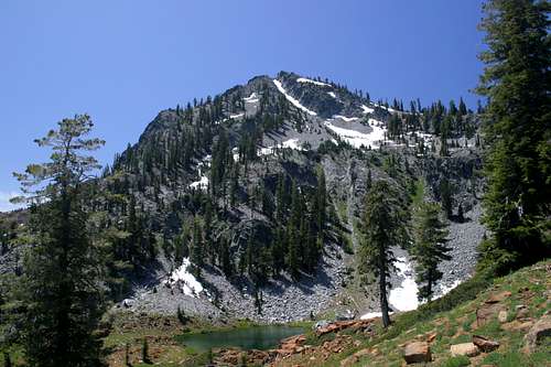
 Siligo Peak and Deer Lake
Siligo Peak is located in the Trinity Alps Wilderness. Normal wilderness rules and ethics apply. A campfire permit is required by the forest service.
Shasta-Trinity National Forest
3644 Avtech Parkway
Redding, CA 96002
(530)226-2500
Weaverville Ranger Station
P.O. Box 1190
360 Main Street
Weaverville, CA 96093
(530) 623-2121
Camping
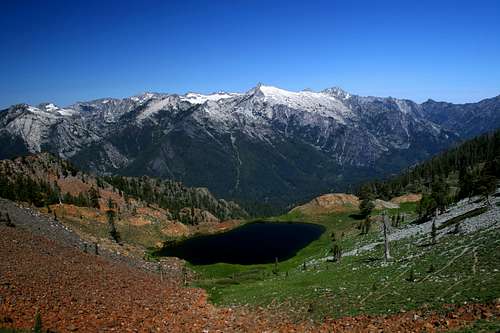 The granite core of the Trinity Alps rises beyond Diamond Lake, on the slopes of Siligo Peak
The USFS operates numerous campgrounds around Trinity Lake. Most are within easy striking distance from either the Stoney Ridge or Long Canyon trailheads. The Stoney Point campground is closest to the Stoney Ridge trailhead while either Alpine View or Preacher Meadow campgrounds are close to the Long Canyon trailhead.
There are numerous excellent campsites along both approach trails. Each of the four lakes in the Four Lakes Loop has descent campsites, but it is preferable to camp in Siligo Meadow or Deer Creek Meadow or even at Echo Lake and then hike the loop and summit Siligo Peak on as a day hike.