
-
 155641 Hits
-
 98.89% Score
-
 92 Votes
|
|
Area/Range |
|---|---|
|
|
41.00020°N / 123.048°W |
|
|
Spring, Summer, Fall |
|
|
9002 ft / 2744 m |
|
|
Overview
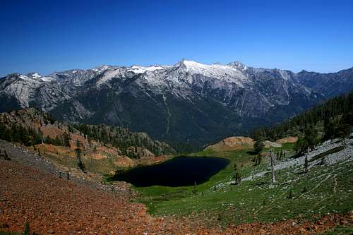
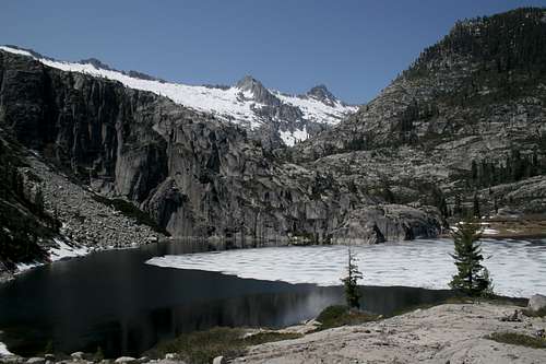
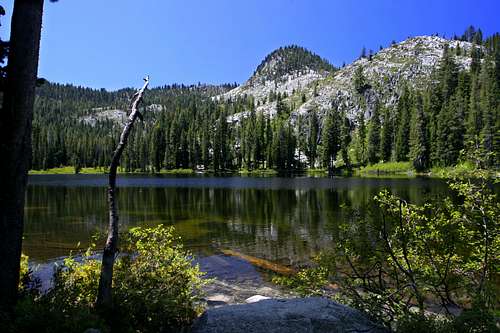
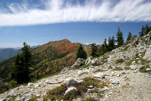
The heart of the Trinity Alps from Diamond Lake
A mountain fastness locked away deep in the penetralia of northern California's Klamath Mountains; the Trinity Alps are a mysterious alpine paradise that offers up some of the western United States' most spectacular, rugged and wild terrain. From unusual red peaks to vast stands of virgin timber to jagged granite turrets, the Trinity Alps are at once reminiscent of the more well known regions like the Sierra Nevada, yet are distinctly unique, with incomparable spectacles. Indeed, this is one of the great American wilderness regions. Few places offer such limitless vistas, spectacular peaks, rugged landscapes, varieties of terrain and biodiversity and sense of vastness as the Trinities. Yet, despite the superlatives, the Trinity Alps receive relatively few visitors. It is not unusual to arrive at one of the more popular destinations in the Trinities and find no one present. The unsung back country is isolation personified. However, whatever intangible qualities the Trinity Alps may have to recommend them, it is the alpine scenery, the ever seductive combination of conifer and meadow, rock and ice and the serene, frightening siren of falling water that will define the Trinities.
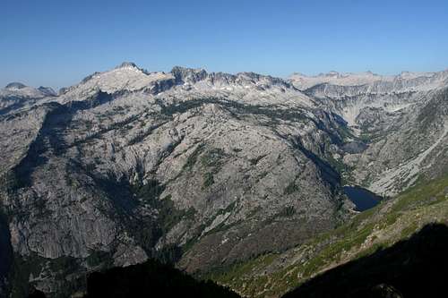
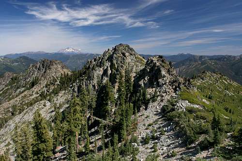
The core of the Trinity Alps from Sawtooth Ridge
Variety is one of the outstanding features of the Trinity Alps. This is manifest in both the geology as well as the flora and fauna. In geologic terms, the range is usually divided into three regions: the Green Trinities, the White Trinities and the Red Trinities. This reflects the varying rock composition in different regions of the wilderness. The plant life also displays stunning variety. 20 species of conifers are documented in the area. This is demonstrated in the small Russian Wilderness, just north of the Trinity Alps, where 17 different species of conifers have been observed in one acre. This is more than anywhere else in the world. Animal life is also diverse. Rare creatures such as the wolverine have been sighted in the Trinities. Trinity County, where most of the Trinity Alps is located, is among the highest in Bigfoot sightings. The mountains here are so rugged and lightly traveled that it is easy to see a creature like the sasquatch living there unnoticed, if one did exist.
Sawtooth Peak from the Boulder Creek Lakes basin
The Trinity Alps is a vast wilderness, encompassing 525,627 acres over parts of three national forests. Little is visible from roads. In truth, a very small part of the wilderness is practically explored on day hikes. The Trinities are a backpacker's wilderness, with over 600 miles of trail. One must penetrate deep into the range and spend several nights in the backcountry to experience the sights these mountains have to offer. One could spends months on the trail and not expend all the trip possibilities available. It should also be noted that, in spite of the abundance of trails, this land is truly wild. Only two peaks in the high eastern half of the range have "maintained" trails to the top and there are numerous "scrambles" (routes so rugged or precipitous the Forest Service refuses to officially recognize it as a trail). Indeed, it is the mystery of mountains seldom seen that is not an insignificant part of the Trinity Alps allure.
 |  |  |  |  |  |  |
 |  |  |  |  |  |  |
History
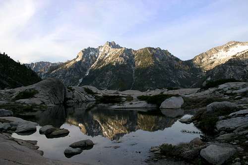
Middle Peak beyond a pool near Echo Lake
The Wintun Indians originally settled the Trinity Alps region. In the early nineteenth century American explorers began to encroach. The famous mountain man Jedidiah Smith passed through the region during his traverse of the western coast of North America. A few years later The Reading Expedition explored the region. Major Reading incorrectly thought the Trinity River flowed to Trinidad on the coast, thus giving the river, mountains and county their name. In truth, the river flows into the Klamath River near the present day Yurok Indian Reservation.
Gold was discovered in 1848 and hordes of prospectors soon poured into the region. Weaverville sprang up quickly and was soon the base of operations for gold miners. Settlements were established deep in what is now the Trinity Alps Wilderness. Evidence of this history can be found in many places, including Canyon Creek. McCay Camp was originally a miner’s camp. In the upper canyon, just below the outlet falls of Lower Canyon Creek Lake, several large iron pipes can be seen in the creek. These are the remains of the nineteenth century Stonehouse mining operation. Even greater evidence of this past can be found in other parts of the Trinity Alps, such as Papoose Lake.
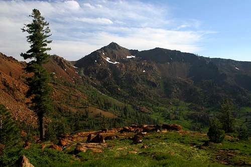
Thompson Peak and Wedding Cake above Upper Canyon Creek Lake
Logging began late in the area. Consequently, most of the Trinity Alps consist of virgin timber. This is particularly dramatic in the Green Trinities, but numerous other locations in the Red and White Trinities also boast some enormous old growth trees. Logging in the Trinity Alps was permanently prohibited when the area was designated the Salmon-Trinity Alps Primitive Area. It was designated wilderness by the 1984 California Wilderness Act.
Cattle ranching has also been a part of the Trinity Alps, primarily in the northern part of the range, in the Scott Mountains region. Ranchers from the Scott Valley drive their cattle up to lush grasslands during the summertime. Other areas in the Trinities, especially the Stoddard Lake area have seen significant ranching activity in the past, though this has decreased significantly.
Geographic Context
Billys Peak, the Trinity Divide and Mount Shasta
The Trinity Alps are located in one of the great, forgotten mountain ranges of the American west. Ask people about the Klamath Mountains and you are likely to get a blank stare. The Siskiyous are well known in southern Oregon and a few people are familiar with the Trinity Alps, but the Klamaths are practically unknown to the general public. Stretching from the North Yolla Bolly Mountains, west of Red Bluff in California, to the Kalmiopsis region of the Siskiyous in southern Oregon, the Klamaths comprise a massive uplift of several million acres, with numerous subranges including the Trinity Alps, the North Yolla Bollys, the Marble Mountains, the Russian Range, the Eddy Range, the Red Buttes, and the Siskyous. The composition of the mountains is a mélange of rock types ranging from granite to marble to serpentine.
Draining these ranges in California are the fantastic Trinity, Salmon, Scott and Klamath Rivers, all classic mountain drainages. In Oregon, the Ilinois, Applegate and Chetco Rivers drain the Siskiyous. Numerous other substantial waterways also flow through the Klamath Mountains. The Klamath Mountains has the highest concentration of federally designated Wild and Scenic Rivers. Quick observation of a map will indicate that the Klamath Mountains is a large grouping of wilderness areas separated by deep canyons containing wild rivers.
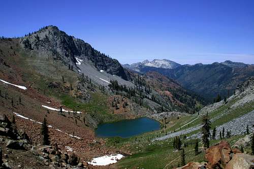
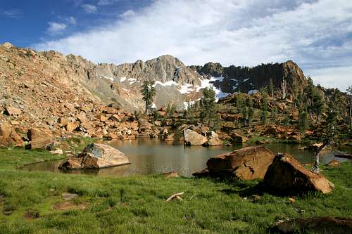
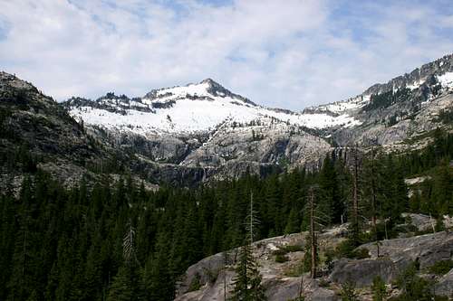
Siligo Peak and Deer Lake
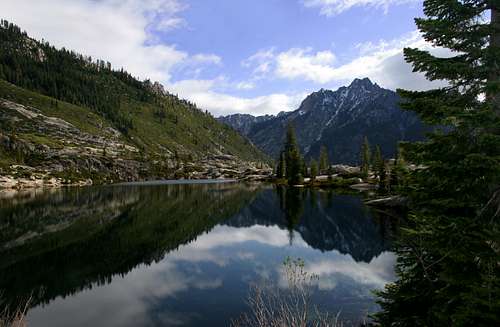
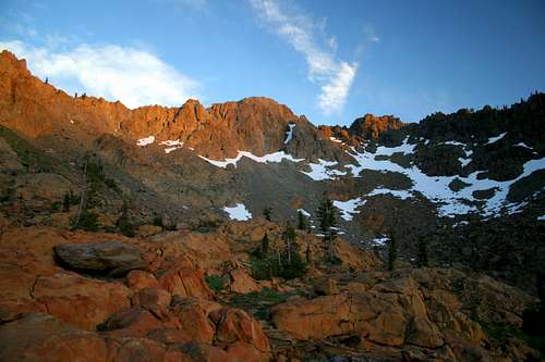
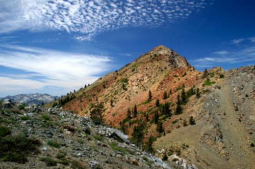
Aside from Mount Eddy, the Trinity Alps are the highest range in the Klamath Mountains. The Trinities themselves can be divided into three distinct regions. In the west are the vast Green Trinities. This area is composed of steep canyons, roaring rivers, sharp ridgelines, and utter solitude. The "green" appellation is derived from the vast stands of virgin timber found in this area. In the east, rising above Trinity Lake, are the Red Trinities. The name comes from the color of the serpentine that composes most of the mountains in this section. Numerous excellent peaks over 8,000 feet as well as an enviable number of lake basins are found in the Red Trinities. Sandwiched between these two attractive regions is the heart of the Trinity Alps, the White Trinities. So-called because of the stark, white granite found in this area, this is the home of the range's highest peaks, largest lakes and most spectacular mountain scenery. It is because of this region that the Trinity Mountains are justly elevated to the Trinity Alps.
The Trinity Alps Wilderness
The Trinity Alps Wilderness contains several different regions within its vast territory. In addition to three distinct subranges, the Trinity Alps are also divided into three subregions. While the subranges reflect the geographic nature of the mountains, the subregions reflect use trends and appearence and is a much more subjective division of the range.Trinity Alps Subranges
The Trinity Alps are divided into three subranges; the Trinity Alps proper, the Scott Mountains and the Salmon Mountains. These subranges are determined by which watersheds they are a part of.
Trinity Alps
Caribou Lake Basin, in the Trinity Alps proper
The Trinity Alps are the largest, tallest and most spectacular part of the Trinity Alps Wilderness. This region is drained by numerous rivers and creeks that ultimately flow into the Trinity River. Nearly all of them flow southward or eastward, intersecting the Trinity as it flows down the eastern flank and southern flanks of the range. Major tributaries include the New River, the North Fork of the Trinity River, Canyon Creek, the Stuart Fork of the Trinity River, Swift Creek and Coffee Creek. The eastern half of this region, between the North Fork and the Trinity River above Trinity Lake, contains the most lakes and sees the most recreational use. Even so, this area is vast enough the absorb many people and still provide and excellent wilderness experience.
East Boulder Lake in the Scott Mountains
The Scott Mountains
The Scott Mountains begin far to the east of the Trinity Alps at China Mountain, where the range merges with the Trinity Divide. While the Trinity Divide contributes its waters to the Trinity, Sacramento and Shasta Rivers, the Scott Mountains form the Divide between the Trinity and Scott Rivers. The range stretches for nearly 20 miles east to west, terminating in the west at Carter Meadow, where the Salmon River Watershed begins. Only the western half of the Scott Mountains are encompassed in the Trinity Alps Wilderness. Nearly two dozen lakes are found in that portion of the Scott Mountains that lies within the wilderness boundary. The Pacific Crest Trail makes its only appearance in the Trinity Alps here, traversing nearly 19 miles of the Scott Mountains crest. Craggy Mountain and Eagle Peak are the only named peaks in the Trinity Alps portion of the Scott Mountains. Nearly all the peaks (Craggy being one of the exceptions) are composed of red peridotite.
Long Gulch Lake, one of only two lakes of significance in the Salmon Mountains
The Salmon Mountains
The Salmon Mountains are similar to the Scott Mountains in that they are found north of the Trinity Alps proper and are encompassed in the Trinity Alps Wilderness. Other than these two attributes, the two ranges could not be more different. While the Scott Mountains reach above 8,000 feet in some areas, the Salmon Mountains rarely exceed 7,000. Only two lakes, Long Gulch and Trail Gulch, are large. The few remaining lakes are little more the frog ponds. The range is much more heavily timbered the most of the Trinity Alps. Consequently, they are usually categorized into the Green Trinities.
Trinity Alps Regions
The Trinity Alps have a complex rock composition. The wilderness is divided into three regions based to some degree on the rock dominant in each area. As stated previously, these divisions are the Green, White, and Red Trinities. The division established by these regions are artificial and reflect the appearance of the region rather than the actual geographic relationship of the mountains.
Thurston Peak is one of the high points of the Green Trinity Alps
Green Trinities
The Green Trinities get their name from the vast forests of virgin timber covering the western portion of the wilderness. Sometimes called the Salmon Mountains, this area is composed of a seemingly unending series of ridges and canyons. A few significant peaks and ridgelines are found here. Notable among these are Salmon Mountain, the Humboldt County highpoint and Thurston Peak, a California prominence peak. Other important peaks are Limestone Ridge and the Devil's Backbone. The most popular trail in the area is the New River Trail and the route leading to the top of Salmon Mountain. In this area "popular" is a relative term, since few people venture into this region and solitude is guaranteed. There are a few small lakes scattered throughout this part of the wilderness, although none of them are as large or spectacular as those found in the eastern half of the Trinity Alps.
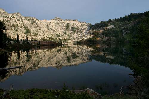
Upper Rush Creek Lake is craddled by Monument Peak in the White Trinities
White Trinities
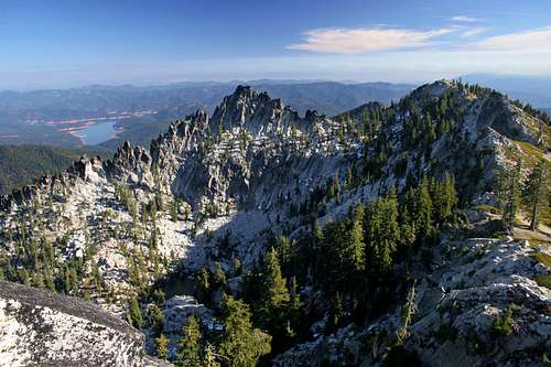
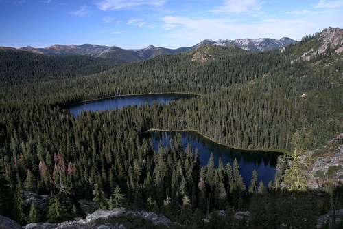
This is the heart of the Trinity Alps. Composed of granite and dominated by soaring, jagged peaks, the White Trinities are what people have in mind when they compare the Trinity Alps to Yosemite or other parts of the Sierra Nevada. It is this area that gave the region its alpine name. Radiating out from Thompson Peak, the highest point of the Trinity Alps, are several dramatic canyons topped by the highest peaks in the range. Thompson Peak also contains the only active coastal glacier in California. The core contains several excellent lakes, including the gorgeous Grizzly and Papoose Lakes, the enormous (72 acres) Caribou Lake, the spectacular Emerald and Sapphire Lakes, and the popular Canyon Creek Lakes. These lakes feed several of the largest drainages in the Trinity Alps, including the North and Stuart Forks of the Trinity River and Canyon, Rattlesnake and Grizzly Creeks. Spectacular waterfalls abound in this area. The potential for rock climbing is virtually unlimited here, although few routes have been established. This is the most popular part of the Trinities, but solitude is still easily obtained here.
The Red Trinity Alps from Stonewall Pass
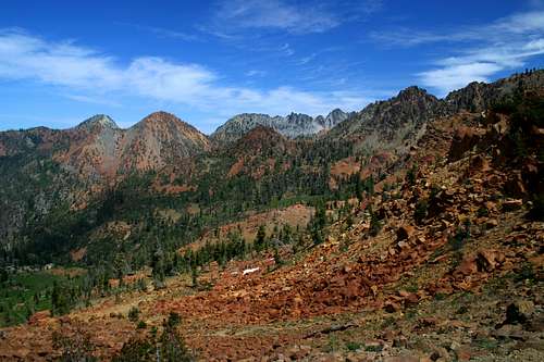
Red Trinities
This is the most complex part of the Trinity Alps. The "Red" appellation comes from the red serpentine and peridotite rock. This is perhaps most evident when standing on Stonewall Pass from which the red hued peaks stretch out to the north. It is important to note that there are still significant intrusions of other kinds of rock. Significant examples of granite in the Red Trinities include Siligo and Gibson Peaks as well as the unnamed "Tangle Blue" peaks and Granite Peak. Sandstone also occurs in the Echo Lake area. The Red Trinities are not only a melange of diverse rock types, but also of diverse sub-ranges. Particularly notable is the divide between the Trinity River and Scott River watersheds. The area in the northeast corner is referred to as the Scott Mountains, which form the headwaters of the Scott River, which flows through Scott Valley into the Klamath River. Numerous lakes are found in the Scott Mountains, as is the seemingly out of place sagebrush. The PCT traverses 17 miles of this section of the Trinity Alps.
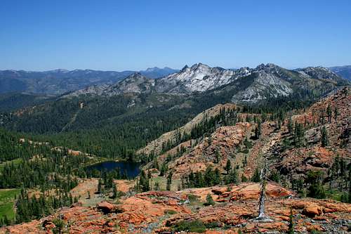
Peaks
Sawtooth Peak reflects in the waters of Boulder Creek Lake
Alpenglow on Middle Peak
The Trinity Alps boasts an exceptional number of peaks, both named and unnamed. Thompson Peak, at 9,002 feet, is the highest in the range. Several peaks in the Canyon Creek area fall just short of this elevation. Only one high mountain, Granite Peak, has a trail to the summit. All other peaks in the Trinity Alps require off trail scrambling and climbing. Most can be summited without any technical effort. The following are the named peaks that exceed 8,000 feet:
Thompson Peak (9,002 ft)
Mt. Hilton (8,964 ft)
Caesar Peak (8,920 ft)
Sawtooth Peak (8,886 ft)
Wedding Cake (8,592 ft)
Caribou Mountain (8,575 ft)
Gibson Peak (8,400 ft)
Sawtooth Ridge (8,278 ft)
Siligo Peak (8,162 ft)
Seven Up Peak (8,121 ft)
Craggy Peak (8,098 ft)
Middle Peak (8,095 ft)
Granite Peak (8,091 ft)
Little Granite Peak (8,043 ft)
Black Mountain (8,019 ft)
There are dozens of other unnamed peaks that exceed 8,000 feet, particularly in the Canyon Creek area and the southern stretch of the Red Trinities. Most of these are seldom visited, despite their accessibility from route leading to more prominent peaks. There is an overabundance of peaks in the 7,000 foot range. The following are some of the more prominent summits that exceed 7,000 feet. The list is by no means exhaustive.
Red Mountain with Monument Peak in the distance
Red Mountain (7,928 ft)
Battle Mountain (7,919 ft)
Sugar Pine Butte (7,861 ft)
Red Rock Mountain (7,853 ft)
Packers Peak (7,828 ft)
Eagle Peak (7,791 ft)
Monument Peak (7,771 ft)
Tri-Forest Peak (7,681 ft)
Thumb Rock (7,697 ft)
Deadman Peak (7,617 ft)
Ycatapom Peak (7,596 ft)
Thurston Peak (7,572 ft)
Weaver Bally (7,504 ft)
Pony Mountain (7,478 ft)
Mumford Peak (7,346 ft)
Billys Peak (7,342 ft)
Snowslide Peak (7,320 ft)
Unofficially Named Peaks
Tapie Peak above Boulder Lake
There are a few peaks in the Trinity Alps that have generally recognized names that have not yet been recognized officially. The most prominent of these peaks is Caesar Peak, just north of Thompson Peak. This massive summit is the second highest point in the Trinity Alps. The current USGS map identifies the peak but most other maps leave the peak unnamed. It is uncertain when the name became recognized officially but it has generally been called various permutations of Julius Caesar Peak, including Caesar Peak, Caesar Cap, Julius Caesar Mountain, Mount Julius Caesar etc. Beta on this peak is scarce.
Billy's Peak Lookout is another unofficially named summit. It is only 67 feet shorter than Billy's Peak, but the two summits are separated by a 1,000 foot saddle. Confusingly, a Forest Service lookout tower was perched on the nameless granite peak east of Billy's Peak. Thus, the unnamed summit became known as Billy's Peak Lookout. A trail leads to the summit.
Trinity Journal Mountain, located just south of Sawtooth Peak, was named decades ago after the newspaper in Weaverville. Other prominent unofficially named peaks include Tapie Peak, above Boulder Lake and Mount Temple, the large crag seen above Siligo Meadows.
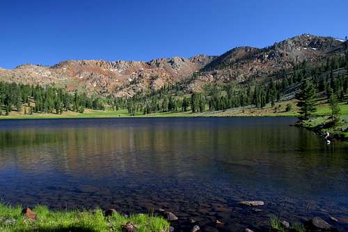
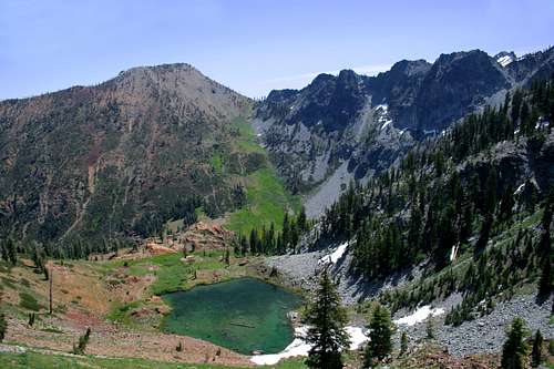
Lakes
Tangle Blue Lake
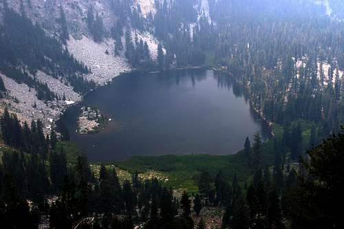
One of the best features of the Trinity Alps is the number of great lakes. Although some lakes are found in the Green Trinities, they are generally small and murky. In contrast, the White and Red Trinities contain dozens of excellent lakes. Most lakes offer great fishing. The lakes in the White Trinities are generally large and are found in high, peak-lined cirques. Caribou Lake, at 72 acres, is the largest in the Trinity Alps. The Red Trinities have more lakes, but they are smaller. Granite Lake (on the back side of Gibson Peak) and East Boulder Lake (32 acres) are amongst the largest in this area. What these lakes lack in size, they exceed in beauty. The Four Lakes Loop exemplifies this. Sunset from Echo or Diamond Lakes is an event not easily put out of mind.
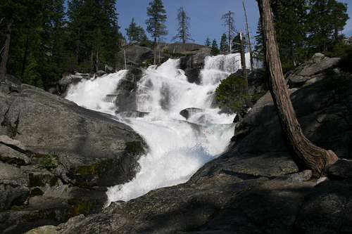
Waterfalls
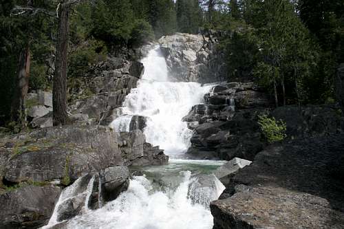
Canyon Creek Falls
The Trinity Alps harbor some of the best waterfalls in California. Grizzly Falls, located beneath Thompson Peak is one of the most spectacular waterfalls to be found anywhere. The Canyon Creek area is also famous for its numerous excellent waterfalls. Some of the best waterfalls are located off Canyon Creek in the Boulder Creek Lakes basin. Most notable of these is a three hundred foot free fall pouring out of the lakes outlet. Outside of these two areas, most of the waterfalls are unnamed. Nonetheless, most of the creeks in the Trinities have substantial cataracts and waterfalls and are worth exploring.
Trailheads
Trinity River from the East Weaver trailhead
There are over 50 official trailheads leading into the interior of the Trinity Alps. Most of these are located along Highway 3, off of Coffey Creek Road and on the Cecilville-Callahan Road. Some of the destinations off these roads include:
Stoney Ridge Trail
Four Lakes Loop
Granite Lake
Long Canyon
Caribou Basin (Caribou Lake)
Stuart Fork (Emerald and Sapphire Lakes)
Boulder Lakes group
Tangle Blue Lake
Two of the most popular trailheads, Canyon Creek and Hobo Gulch, are located off of Highway 299, west of Weaverville.
Trailhead Map

Getting There
Red Mountain from Granite Peak
Paved roads form a ring around the Trinity Alps. Highway 299 provides access to the southern area. Heading north from Willow Creek, Highway 96 skirts the western boundary of the wilderness. Leaving Highway 96 and heading east is the precarious Salmon River Road. At the village of Cecilville this route improves and becomes the Cecilville-Callahan Road. At the town of Callahan this route intersects Highway 3, which heads south and intersects HIghway 299 at Weaverville.
Highway 299 is the main artery connecting Eureka and Redding. This highway is accessed off of Highway 101 at Arcata in the west while it intersects Interstate 5 at Redding. If coming south from Oregon, it is possible to take Highway 3 at Yreka. However, unless one is planning on accessing trails in the northern part of the Trinity Alps, it is faster to continue on to Redding and take Highway 299. The Coffey Creek Area is probably about as far south as one should consider advisable if planning on taking Highway 3 from the north.
Camping
Stoddard and McDonald Lakes provide numerous campsites
There are dozens of USFS campgrounds on all sides of the Trinity Alps. The Rush Creek and East Weaver campgrounds are closest to Weaverville on Highway 3. The Junction City campground is the the nearest to Weaverville on Highway 299. The free Ripstein campground is a short distance from the Canyon Creek trailhead. Dispersed camping is available along many of the unpaved access roads leading to trailheads.
Red Tape
Red Mountain above Van Matre Meadow
Boulder Creek Lakes basin
The Trinity Alps is encompassed in the Trinity Alps Wilderness. Normal wilderness rules and ethics apply. A campfire permit is required by the forest service. No campfires are permitted in the Boulder Creek drainage.
The Trinity Alps Wilderness contains parts of three National Forests.
Shasta-Trinity National Forest
3644 Avtech Parkway
Redding, CA 96002
(530)226-2500
Weaverville Ranger Station
P.O. Box 1190
360 Main Street
Weaverville, CA 96093
(530) 623-2121
Klamath National Forest
1312 Fairlane Road
Yreka, CA 96097-9549
(530) 842-6131
Salmon River & Scott River Ranger Districts
11263 N. Highway 3
Fort Jones, CA 96032-9702
(530) 468-5351
Six Rivers National Forest
1330 Bayshore Way
Eureka, CA 95501
(707) 442-1721
Lower Trinity Ranger District
Highway 96
P.O. Box 68
Willow Creek, CA 95573
(530) 629-2118
Pacific Crest Trail
Mt. Shasta and Mt. Eddy from the PCT in the Trinity Alps
The Pacific Crest Trail (PCT) extends 2,650 miles from Mexico to Canada. Of that distance, only 18.9 miles crosses the Trinity Alps. The trail avoids the high core of the Trinities, instead passing through a part of the Red Trinity Alps in the extreme northeast corner of the wilderness area. The PCT traverses the long ridge of the Scott Mountains. Along the way the trail passes numerous great lakes that provide excellent diversions and campgrounds. The trial reaches the summit of 7,790 ft. Eagle Peak and skirts and passes within easy striking distance of the gorgeous East Boulder Lake basin. Views of Mt. Shasta are constant and spectacular. Numerous day hikes can be created from various parts of the PCT. Prior to reaching the Trinities, the trail passes near the summit of Mt. Eddy and passes through the Deadfall Basin. After leaving the Trinity Alps, the PCT continues north, through the Russian Wilderness. Access to the trail is off of Forest Highway 93, west of Callahan and off of the Marshy Lakes Road which connects to Highway 3.
Trinity Alps Names
Seven-Up Peak and Dolomite Ridge beyond Luella Lake
The pioneers in this region were unimaginative in the way they named the landmarks they observed. Trinity Alps names tend to be straight ahead, no frills affairs. Canyon Creek is an apellation that hardly does justice to the spectacular granite canyon. Mountains tend to be "______ Peak" or "_______ Mountain", usually lacking a distinctive moniker. Ycatapom Peak is the most significant deviation from this pattern. Trinity Alps lakes are even worse. While Billy-Be-Damned and Tangle Blue Lakes are the exception to this rule, most lakes in the Trinities have an unfortunate and confusing set of names. For example, the Boulder, East Boulder, West Boulder, Upper Boulder Lakes are not to be confused with the Big and Little Boulder Lakes or the Boulder Creek Lakes.
If the name of a destination does not inspire you, persevere and be reassured that most destinations in the Trinity Alps are spectacular and the lackluster name may have discouraged others from going there too.
Additional Information
Big Marshy Lake and the unnamed "Tangle Blue Peaks"
Sunset at Lower Caribou Lake
Print Resources
The Trinity Alps remain relatively unknown to most Americans, even most Californians. Nonetheless, they are growing in popularity. This is reflected in the fact that four hiking guides exist for the wilderness. Each has good information and between the four of them a thorough idea of what possibilities the Trinities offer can be synthesized. Even so, there is little information on the Green Trinities, which remain thoroughly empty of people.
Maps
The usual USGS quads are available for the Trinity Alps. Another good option is the USFS trail map for the Trinity Alps Wilderness. This map is large and cumbersome, but still a very good resource for the area. The Trinity Alps is a good candidate for a new, high grade trail map.
Logistical Centers
Weaverville is the gateway community to most of the Trinity Alps. It has a great supermarket (with a Starbucks for the foo foo coffee junkies) and numerous hotels of varying levels. There are several good restaurants as well. Most of the best trailheads are accessed from Weaverville along Highways 299 and 3.
Callahan is the largest community near the northern part of the Trinity Alps, specifically the Scott Mountains region and the northern access point for Grizzly Lake. No services are found in Callahan except a Forest Service ranger station and a small convenience store. Etna, 13 miles north on Highway 3, is the closest source of goods.
Willow Creek is the best source of supplies for the western part of the range.
Current Forecast
Current NOAA / National Weather Service Forecast for Mount ShastaSpring 2009 Conditions
Trinity Alps Map
East Half
The eastern half of the Trinity Alps is the tallest, most rugged part of the Trinity Alps Wilderness. The White and Red Trinities are found here. The region has dozens of lakes and numerous peaks exceeding 8,000 feet, including 9,002 foot Thompson Peak, the second highest point in the Klamath Mountains. The northern part of this area is part of the Scott Mountains region.

West Half
The western half of the Trinity Alps Wilderness is usually referred to as the Green Trinities. This area is lower and contains far fewer lakes than the eastern half. The area is characterized by large north-south ridges and vast stands of ancient forest. The northern part of this region falls into the Salmon Mountains region.

External Links
Middle Canyon Creek Falls
- Shasta-Trinity National Forest
- Klamath National Forest
- Six Rivers National Forest
There is an unfortunate paucity of good information for the Trinity Alps on the internet. Hopefully the Forest Service will improve their online resources in the future.
jartelt - Feb 15, 2018 11:10 pm - Hasn't voted
Additional external linkI just wanted to suggest adding a link to the External Link section of the Trinity Alps page. I wrote up a report describing my backpacking trip to Emerald and Sapphire Lakes in the Alps and think it could be useful to some. Here is the link: https://backpackersreview.wordpress.com/trip-reports/trinity-alps-emerald-lake/