
-
 49325 Hits
-
 80.49% Score
-
 12 Votes
|
|
Route |
|---|---|
|
|
40.94386°N / 122.89925°W |
|
|
Hiking, Scrambling |
|
|
Spring, Summer, Fall |
|
|
Overview
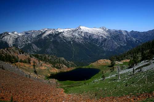 The Trinity Alps from above Diamond Lake.
The Trinity Alps contains some of California’s best and most spectacular trails. Outside of the Sierra Nevada, few areas in the Golden State can rival the ruggedness and spectacular vistas found in this vast and relatively unknown wilderness.
The Trinities constitute the heart of the Klamath mountains, an incredibly rugged range found in northwest California. The Klamaths are an very diverse range, composed in a spectacular mélange of rock types including granite, peridotite, serpentine, limestone, sandstone and marble. Most of these are found in the Trinity Alps, but granite, peridotite and serpentine are most common. Most of the granite is found in the core of the Trinities, in the Canyon Creek area. This is generally referred to as the White Trinities. To the east, red peridotite and serpentine are most abundant, although there are significant granite intrusions. This area is referred to as the Red Trinities.
The Four Lakes Loop is probably the most spectacular trail in the Red Trinities, and certainly holds its own against the best trails in the White Trinities. It contains some of the best vistas to be found in northwest California, passes some of the prettiest lakes, climbs an excellent peak and is generally exciting in nature, perched precariously high above the four glacial basins it travels through.
The Loop is the primary route to climbing Siligo Peak.
Access
 Siligo Peak and Deer Lake from Deer Creek Pass
The Four Lakes Loop can be accessed via four different trails. Although the loop itself is 5.2 miles long, the shortest route to the beginning of the loop is 6 miles. The result of this is that the loop is generally not done as a (ridiculously long) day hike. Instead, people generally establish a base camp at one of the lakes (usually Deer Lake) or in the nearby Siligo Meadows.
The shortest access route, at six miles, is the Long Canyon Trail. This is the most popular trail leading to the Four Lakes Loop. The 8.2 mile long Stoney Ridge trail also provides access and is in many ways the preferred approach route. Both trails terminate at Deer Creek Pass. The Deer Creek Canyon trail and the trail leading down from Seven-Up Gap also provide access to the Loop below Deer Lake, but these are only reached via long approaches (both in access of 15 miles) and are generally only used as part of longer, week long treks.
Route Description
The Four Lakes Loop can be hiked either clockwise or counter-clockwise. Either way yields the same elevation gain and lost. However, it is generally better to hike the trail clockwise, since this puts all the best vistas in full view, rather than behind the hiker. Summit Lake from the Four Lakes Loop
If approaching via either the Long Canyon or Stoney Ridge trails, the Loop begins at Deer Creek Pass. From there it descends slightly, then swings to the west, traversing the cirque high above Deer Lake. Deer Creek Canyon and Caribou Mountain can be seen beyond the lake. Siligo Peak looms above Deer Lake, providing an impressive view of the granite summit. Snow often lingers on the trail in this north-facing basin. The trail eventually switchbacks up to a pass. The path immediately levels off and 13 acre Summit Lake comes into view. A short trail leads down to the lake, which lies beneath an unnamed 8,000 foot peak.
Climbing Siligo Peak
The off trail route to the Summit of Siligo Peak departs to the north from this point. The summit of the peak can be seen and there are a couple of faint use-trails leading up the ridge. Reaching the summit requires a 350 foot climb up a narrow ridge.
 Luella Lake
The trail continue west, remaining fairly level. In short order it reaches another saddle. This is potentially the spectacular vista on the trial. To the west, the granite core of the Trinity Alps forms the horizon. All of the high peaks, Hilton, Wedding Cake, Sawtooth, Thompson, Caesar and Caribou all seem so close one could reach out and grasp them. Immediately below lies the perfectly proportioned and inviting Diamond Lake. The lake rests on a precipice above the canyon containing the Stuart For of the Trinity River. The bare granite face of Siligo Peaks towers above the trail, which switchbacks down to Diamond Lake. The grand view remains prominent throughout the descent, constantly changing perspective as the lake is approached.
 Deer Creek Pass from Deer Creek Meadow
 Deer Lake
The trail descends to Luella Lake, again switchbacking precariously down the west side of the cirque. From the lake, the trail continues east and switchback further down into Deer Creek Canyon. Once at the canyon bottom, the gorgeous Deer Creek Meadow opens up in a broad, grassy expanse. Seven-Up Peak and Dolomite Ridge tower majestically to the east. The trail leading up to Seven-Up Gap can be seen faintly in the distance. To the south, Deer Creek Pass, the loops terminus can be seen, with the granite towers of Gibson and Siligo Peaks standing sentinel. The Deer Creek Canyon trail and the trail to Seven-Up Gap join the Four Lakes Loop here. Once the meadow is reached, the trail turns south and approaches the climb to Deer Lake. Diminutive Round Lake is found here, but is really more of a small pond than a lake. Nonetheless, it makes an idyllic stop or campsite.
All too soon, Deer Creek Meadow is left behind and the long climb up to Deer Lake begins. This is the hardest part of the trail. Towards the top, the trail moves closer to Deer Creek as it crashes down it steep course. At the top, the creek passes through a short, but narrow granite gorge. The trail crosses the outlet of the lake and skirts its east shore. At the north end of the lake, the final climb of the loop begins, as the trail makes the final, switchbacking ascent up to Deer Creek Pass.
Camping Around the Four Lakes Loop
 Mount Temple above Siligo Meadow
There are numerous fantastic places to camp along the Four Lakes Loop. Each lake has excellent campsites. Deer Creek has one good site, but it is the most popular due to its proximity to the junction of the Stoney Ridge Trail and the Long Canyon Trail. Diamond Lake's site is the best, with an incredible view of the granite core of the Trinity Alps. Deer Creek Meadow and Siligo Meadow offer more expansive camping for those who do not want to impact the lake areas or have larger groups.
Maps

