
-
 32147 Hits
-
 84.26% Score
-
 18 Votes
|
|
Mountain/Rock |
|---|---|
|
|
40.74670°N / 110.7681°W |
|
|
12718 ft / 3876 m |
|
|
Overview
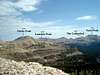
 Ostler Peak from Amethyst Lake Trail
Ostler Peak is the rugged summit forming the western rim of Amethyst Basin, in the High Uintas Primitive Area of north-eastern Utah. A hike to the summit of Ostler Peak can be made either as a long day hike, or an enjoyable and scenic backpacking trip.
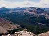
This peak is the northern neighbor of nearby Spread Eagle Peak, which lies on thr ridge ±1.5 miles to the southwest. From the summit of Ostler Peak are outstanding views of the popular Amethyst Lake area to the east, and the Ryder/McPheters Lake area to the west.
With 1,138 feet of prominence, the peak ranks as #30 on the list of Utah 12,000+ foot peaks with 300+ feet of prominence, as compiled by Scott Patterson.
Ostler Peak is located in the Kamas Ranger District of the Uinta-Wasatch-Cache National Forest.
USGS 1:24,000 Quad:
 |  |  |
Getting There
The shortest approach to Ostler Peak is by way of the Ostler Fork (Amethyst Lake) trail, which begins at the Christmas Meadows trailhead.To access the trailhead take Utah State Highway 150, heading either south from Evanston, Wyoming, or north from Kamas, Utah. Near mile marker 46 a gravel road leaves the highway on the east, and heads southeast approximately 4 miles to the Christmas Meadows Campground. The trailhead parking area is located a short distance beyond the campground.
The gravel road is well graded and passable by most passenger vehicles when dry.
 |  |
Routes
Common routes for climbing Ostler Peak include:Refer to the 'Routes' section of this page for details on ascending the peak.
Red Tape
The trailhead is located along the Mirror Lake Scenic Byway, a 42-mile section of road located between Kamas, Utah, and Evanston, Wyoming. All motor vehicles parked in this area must display a valid recreation pass. These passes may be purchased at the Christmas Meadows Trailead (self-service), or at various other self-service locations along Highway 150.Fees are $6.00 per day, $12.00 per week, or $45.00 annually.
When To Climb
The normal summer hiking season in the Uintas runs from July through September, but may vary considerably depending upon the previous season snowpack and the first significant snowfall of the season.Camping
A campground is located at the Christmas Meadows trailhead. There are also numerous backcountry campsites along the approach trail.A backcountry campsite near Ostler Lake would provide a scenic and strategically placed basecamp for a 2 or 3-day backpacking trip.
Mountain Conditions
Links to local weather, road conditions, and fire information can be found on the Uinta-Wasatch-Cache National Forest website.The National Weather Service also provides a forecast for the region.