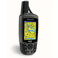
The GPSMAP® 60CSx is a refreshing upgrade of the GPSMAP 60CS, one of our most popular models for outdoor and marine use. This unit features a removable microSD card for detailed mapping memory and a waterproof, rugged housing. The microSD card slot is located inside the waterproof battery compartment. Users can load map data and transfer routes and waypoints through the unit’s fast USB connection.
In addition, this unit features a new, highly sensitive GPS receiver that acquires satellites faster and lets users track their location in challenging conditions, such as heavy foliage or deep canyons. The GPSMAP 60CSx also incorporates a barometric altimeter for extremely accurate elevation data and an electronic compass that displays an accurate heading while standing still.
Considered the mainstay among serious outdoor enthusiasts, the GPSMAP 60CSx and GPSMAP 60Cx offer a large color TFT display and turn-by-turn routing capability. Each unit comes with a blank 64 MB microSD card. Owners of these new x-series handhelds can also purchase new microSD cards that are pre-loaded with MapSource® Topo and inland lake maps, BlueChart® marine cartography, and City Navigator™ street maps.
Features
New high-sensitivity WAAS-capable GPS receiver by SiRF
Built-in quad-helix receiving antenna with remote antenna capability
Unit dimensions: 2.4” W x 6.1” H x 1.3” D
Display: 1.5” W x 2.2” H, 2.6”-diagonal, 256-color, transflective TFT (160 x 240 pixels)
Supports English, Spanish, Portugese, and French languages.
Weight: 7.5 ounces with batteries (not included)
Sensors:
-Electronic compass displays accurate heading while standing still
-Barometric altimeter
microSD card slot allows for storage of optional MapSource detail (64 MB microSD included)
LED backlit display and keypad
Battery life: 18 hours (typical use) using two AA alkaline batteries
Includes a built-in Americas autoroute basemap with automatic routing capabilities, including highways, exits, and tide data (USA only)
Internal memory is preloaded with a marine point database
1,000 user waypoints with name and graphic symbol; 50 reversible routes
Position formats include Lat/Lon, UTM, Loran TDs, Maidenhead, MGRS, user grid, and more
Large-numbers option for easy viewing; dual-position display mode
Trip computer provides odometer, stopped time, moving average, overall average, total time, max speed, and more
10,000-point automatic track log; 20 saved tracks (500 points each) let you retrace your path in both directions
Elevation computer provides current elevation, ascent/descent rate, minimum/ maximum elevation, total ascent and descent, average and maximum ascent and descent rate
Navigation instructions can be shared with repeaters, plotters, and autopilots using NMEA protocols through the dedicated serial port
Built-in celestial tables for sun and moon calculations and the best times to fish and hunt
Compatible with most MapSource products. See the MapSource Compatibility table (top right) for a list of software that Garmin recommends with this product.
This GPS is above and beyond what I thought it would be. It is much easier to use than my last GPS, Magellan Explorist 600. It uses AA batteries and they last long. It has many features, way more than the features that you read about in this review and other reviews.
Best price I found when searching for it was on thenerds.net
Thanks for the link, I was about to purchase the 62 elsewhere and the cheapest I found it was Amazon for almost $50 more. Or REI for $100 more, and Garmin's website is over $100 more. Thanks!
It has fewer bugs than the 60c had at introduction, but has had a few bugs still-- such as an insistence that the direction arrow should be 180 degrees off (fixed in my last firmware update).
The reception is stronger than with the 60c, but don't expect miracles. It still cuts out in deep canyons, and doesn't do any better at distinguishing reflections from real signals.
The screen is brighter than with the 60c, and I do appreciate the expandable memory.
The windshield mount is problematical; I prefer the mount on my old Magellan STPro.
A nice touch: with the new SiRF chipset, you can basically turn off WAAS; you'll still get an EPE of 11' under a clear sky, without the extra power consumption.
A word of warning: if you use the altimeter self-calibrate for a hike that starts in a deep valley, turn the unit on for the drive to your starting point, then zero the log. If you turn it on in a deep canyon, the altitude calibartion may be wacky.
This is a great GPS. Has tons of features, compact (I put it in my jacket pocket and don't even now it's there). Only draw-backs are its expensive and you only have about 15 readable letters in the notes for your waypoints.
I recently dropped my 60csx in about 12 inches of water, not knowing that it fell out of my pack. The next day I realized it was missing, and hopped in the kayak and checked my last campsite. As I was making a portage at a shoreline I observed it sitting in the water at the edge of the lake right where I was making shore.
I turned the unit on and it functioned without a problem.
The only thing I did when I got this unit was placed a small amount of silicone around the back cover plate where it seals the battery compartment.
Compared with other Garmin models I've had, this one wins hands down. As far as better reception than other models, the proof is in the pudding; just compare and you'll see. It's easy to use although I've noticed that when you have it in a protective case, the scroll button (called the Rocker Key) in the middle takes a bit of pressure to use because of the case's transparent plastic window sitting over the button. This model is larger than other Garmin models and of course you have that protruding antennae. But I got used to those things.
The electronic compass and barometric altimeter are great features.
The memory card from the factory is rather small. It's worthwhile from the outset to buy a larger one (256MB for example) so that you'll have all the capacity you need to store routes, etc.
The Waypoint Manager software is easy to use for transferring data to your computer from your unit.
The GPSMap60CSx is pricey (when I bought my first one I paid $499 at REI). I lost that unit last fall--AND HERE IS A WARNING TO HEED: if you use the plastic clip that screws into the back of the unit so that you can attach the unit to your belt or pack stap, check regularly to make sure the unit does not become unscrewed from the plastic clip. This happened to me. One moment my GPS was clipped to the pack strap over my chest and the next moment the unit had unscrewed and all I had left was the plastic clip attached to my strap (I was on very steep terrain and my GPS must have slid quickly down the slope; I never did find it). I was hesitant to shell out for a replacement right away. Then I noticed that the price had gone down to $449. This month, REI put this model on sale for $349 and with a $50 rebate from the manufacturer. End result--"only" $299 for a model that cost $200 more originally. This is a great price for that model.
What a like most on the these GPS is the posibility of downloading maps to the device. Here in latin America there is not updated maps and Garmin seems not to be worry to develop it. Althought there are independent projects as "proyecto Mapear" and "Projeto Tracksource" from Argentina and Brasil that are developing there own maps.
I downloaded those maps to my last expedition in Argentina, Chile and Bolivia and I used it not only in the mountain, but in the roads and in the urban areas...
So, these GPS could be used in natural areas and also in urban ones...
Another thing I like is the Antenna sensibility. For the first time I could navigate inside the rain forest without losing signal.
I think there is a lot of things to increase on the GPs devices... Let's wait for the one that you can download raster imagens to GPS.. these would be a revolution!
....than the 60cs. This is a far superior product. It appears to me that once Garmin fixed all the bugs of the 60cs, they simply re-issued the unit as the "x". The reception is much better and acquires sats much faster. The 60CS was such a piece of crap that I'm surprised that I bought this one, but I'm very happy so far.
Yeah, a great product. I dropped this thing in many a time and it still keeps on tickin'. I even dropped it a couple of times in shallow pools of water while canyoneering and it is indeed waterproof which was a big friggin relief to find out. Strong signal. Works even in canyons, well not all the time, but for a pretty good chunk of the time.
Like the high sensitivity receiver, good battery life and especially the pre loaded topo maps. Turn the electronic compass off to save battery if not using.
I love my garmin, I guess I'm not too sure how to use all of the options yet, I only know the basics, Routes and track. Nothing beyond that. I would like to buy the very best Topo Software for it, i was told that Topousa 2008 was the one to get. I have Delorme and the Maps are awesome. Is this true of 2008? Love the GPS though!!!!!
This unit is the best for the money, if not the best period (based on my research). Super accurate, waterproof, and durable. Easy to use in the field. Also easy to use at home on the PC with Mapsource. Tons of free (legal) maps online that can be downloaded. The compass is as reliable as any compass in my mind. Even my regular orienteering compass can be misleading at times. What I've learned to do is always carry both. Whenever something doesn't seem right I always compare the 2 side by side. Then usually one or the other needs slightly re positioned and your good to go! Highly recommend!


redsplashman23 - Mar 8, 2007 1:49 pm - Hasn't voted
Great UnitBest price I found when searching for it was on thenerds.net