
|
|
Area/Range |
|---|---|
|
|
41.72500°N / 23.46900°E |
|
|
9560 ft / 2914 m |
|
|
Overview
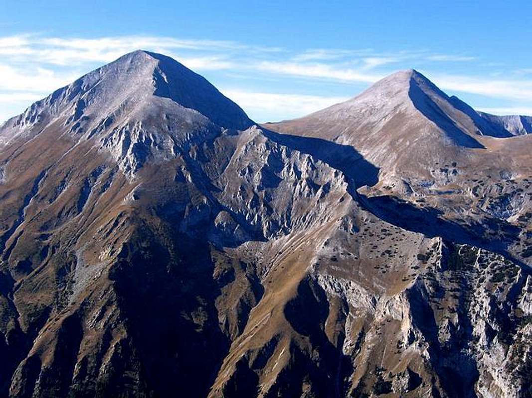
Vihren (2914 m) & Kutelo (2908 m) - The Giants of Pirin
PIRIN mountain is the second highest in Bulgaria after Rila (Musalla, 2925 m) mountain. It is situated in the southwest part of the country in a rather extended shape to the northwest and southeast between the rivers Struma and Mesta. Geologically, Pirin, Rila, Karpati & Rodopi belongs to group of very old mountains.
The range extends about 40 km northwest-southeast, and about 25 km wide. Most of the range is protected in a national park, the Pirin National Park (wide area of 40.447 ha).
Extending over an area of 27.400 ha and lying at an altitude of 1,008–2,914 m in the Pirin mountains, in south-west Bulgaria, Pirin National Park has a limestone Balkan landscape, with lakes, waterfalls, caves and pine forests. The rugged mountains, with more than hundred glacial lakes scattered throughout them, are home to hundreds of endemic and rare species, many of which are representative of the Balkan Pleistocene flora. The mountains also have diverse and unique landscapes of great aesthetic value.
Pirin mountain, a glorious glacial landscape of peaks and lakes, offers some of the finest hiking and climbing in Europe. Pirin has acquired an Alpine relief - rocky marble or granite peaks and cliffs, deep cirques, well shaped glacier valleys and numerous lakes. However, because of the well-expressed Mediterranean influence through the valleys of the Struma and Mesta rivers, it is the mountain with the greatest number of sunny days throughout the year and annual average temperature in the area of Vihren Hut (1950 m) of -3.7C.
Northern Pirin is the home of the highest peak, Vihren (2914m), of 60 peaks above 2500m - 3 peaks above 2900 m, 7 peaks above 2800 m and 14 peaks above 2700 m, and of beautifully glacial lakes (140-150 in number, from them more than 100 in central massif).
It is also the place where one can find most of the region's ski resorts and hiking centers, as well as 13 chalets and 4 huts which are open for mountaineers the year-round. Because of its unique nature, in 1983 UNESCO decided to include the Pirin National Park in the list of the world's cultural and natural heritage. So, the "Pirin National Park" is included in the UNESCO Convention for the Preservation of World Wildlife Heritage. Therefore Pirin belongs not only to Bulgaria, but also to the world!
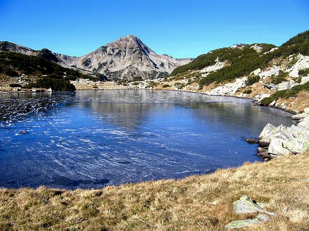
Banderishko Lake - the beauty of Pirin
Situated in the highest reaches of the Pirin Mountains, Pirin National Park encompasses rugged alpine peaks that rise above 8,202ft (2,500m) and more than 100 glacial lakes spread at their feet. The magnificent landscape is made up of old forests, waterfalls, caves and areas of limestone that are home to the near extinct edelweiss and the Pirin poppy.
Characteristic to the park is the abundance of rare and endemic species of plants and animals, and the unique environment is listed as a UNESCO World Cultural and National Heritage site, with a wide variety of flora and fauna. Alpine mountaineering and skiing are popular, and together with the cultural heritage of the surrounding mountain settlements and stunning scenery, Pirin National Park is an attractive tourist destination.
 |
 |
 |
 |
Pirin massif
As i said, the Pirin range extends about 40 km northwest-southeast, and about 25 km wide, extending over an area of 27.400 ha and lying at an altitude of 1,008–2,914 m.
Beautiful and large massif of Pirin is the home of many high peaks. From all of them, about 50 peaks above 2500 m, from them 3 peaks above 2900 m, 7 peaks above 2800 m and 14 peaks above 2700 m.
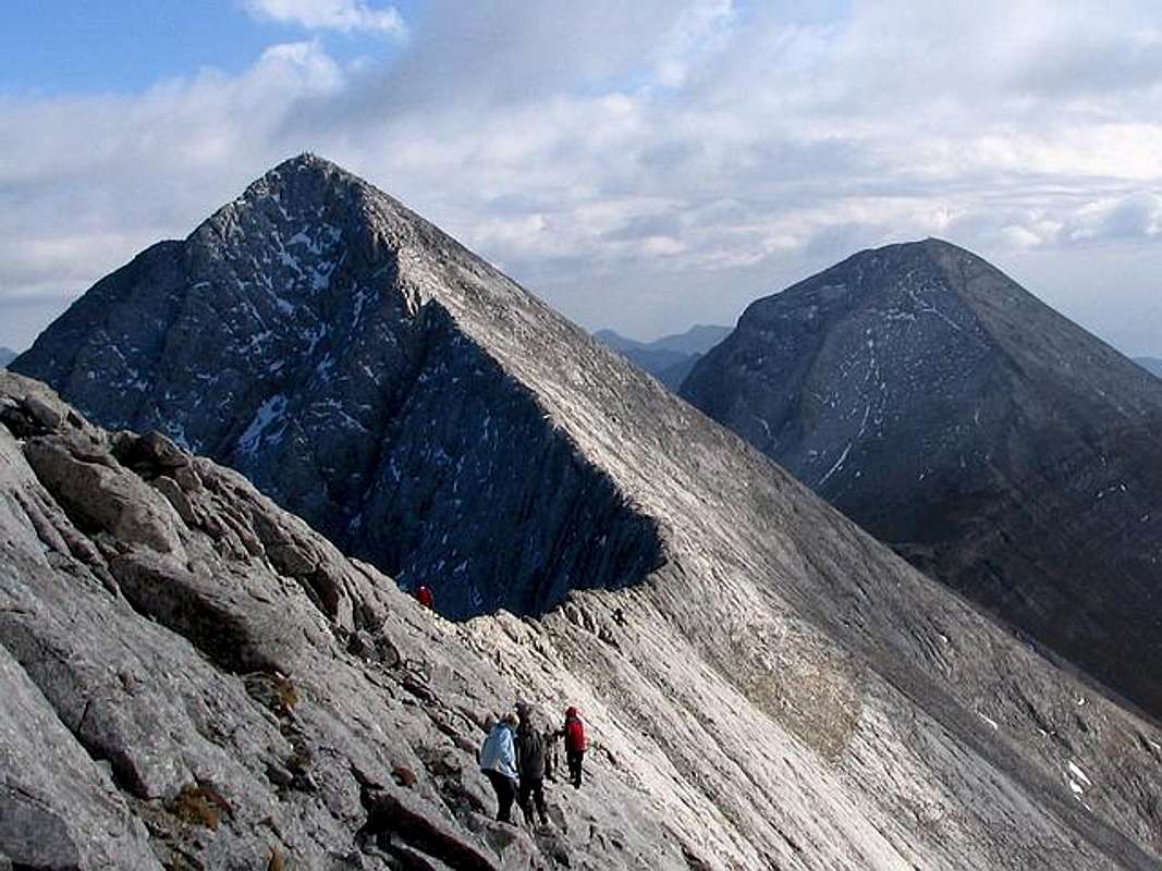
Kutelo (2908 m) & Vihren (2914 m) - highest peaks of Pirin massif
Here is the list of the highest one:
~ Vihren (2914 m)
~ Kutelo I (2908 m)
~ Kutelo II (2906 m)
~ Banski Suhodol (2884 m)
~ Polezan (2851 m)
~ Koncheto (2850 m)
~ Kamenica (2822 m)
~ Malek Polezan (2822 m)
~ Banovi Dupki (2820 m)
~ Strazite (2800 m)
~ Jalovarnika (2763 m)
~ Voivodski Vrh (2761 m)
~ Izvorec (2753 m)
~ Todorin Vrh (2746 m)
~ Banderiski Cukar (2731 m),
~ Samodivski Vrh (2730 m)
~ Momin Dvor (2725 m)
~ Glavniski Cukar (2720 m)
~ Malka Todorka (2712 m)
~ Krivec (2709 m)
~ Todorina Porta (2702 m)
~ Disilica (2700 m)
~ Kameniska Kukla (2690 m)
~ Kuklite (2686 m)
~ Cerna Mogila (2682 m)
~ Kraljev Dvor (2680 m)
~ Malka Kamenica (2679 m)
~ Zeleznik (2673 m)
~ Orlovec (2668 m)
~ Graniten (2669 m)
~ Valijaviski Cukar (2664 m)
~ Zboljt (2650 m)
~ Golem Tipic (2645 m)
~ Golemata Strana (2644 m)
~ Hvoinati Vrh (2635 m
~ Golena (2633 m)
~ Vljzela (2620 m)
~ Vasilaski Cukar (2615 m)
~ Gredaro (2605 m)
~ Prevalski Cukar (2604 m)
Koncheto ridge & Banski Suhodol (2884 m)
 |
 |
 |
Bansko
Bansko is a small Bulgarian town located in Southwestern Bulgaria, in the district of Blagoevgrad, located at the foot of the Pirin mountain at an altitude of 936 m above sea level, with approximately 10.000 citizens. The town is situated at the crossroads of important routes from Central Bulgaria to Greece. The distance from Sofia to Bansko is 160 km. From the foot of Vihren (2914 m) Bansko is 18 km far.
Situated in the foothills of one of the country's most beautiful mountains, Bansko is a charming and historic town with the stunning alpine backdrop formed by the Pirin Mountains. A climatic mountain resort, Bansko is known as an alpine skiing, hiking&climbing centre, but it combines its natural beauty and outdoor opportunities with the atmosphere of an ancient Bulgarian town from the 10th century, and boasts a wealth of culture and history, as well as traditional taverna-style cuisine and colourful folklore. The traditional stone and wooden buildings are an integral part of its charm and character and many relics and monuments survive from its past. The alpine character of the Pirin Mountains create excellent skiing conditions for all types of skiers and experts can enjoy some of the country's best downhill skiing at the nearby resort of Shiligarnika.
Surrounded by Pirin, Rila and Rhodopa mountains, Bansko is a climatic mountain resort with a short summer and long winter. The average temperature during january, the coldest month, is -1.9C. Snow falls are abudant, providing a constant winter snow cover up to 2 m thick. The skiing season along the Pirin slopes starts in the middle of December and ends in mid-April.
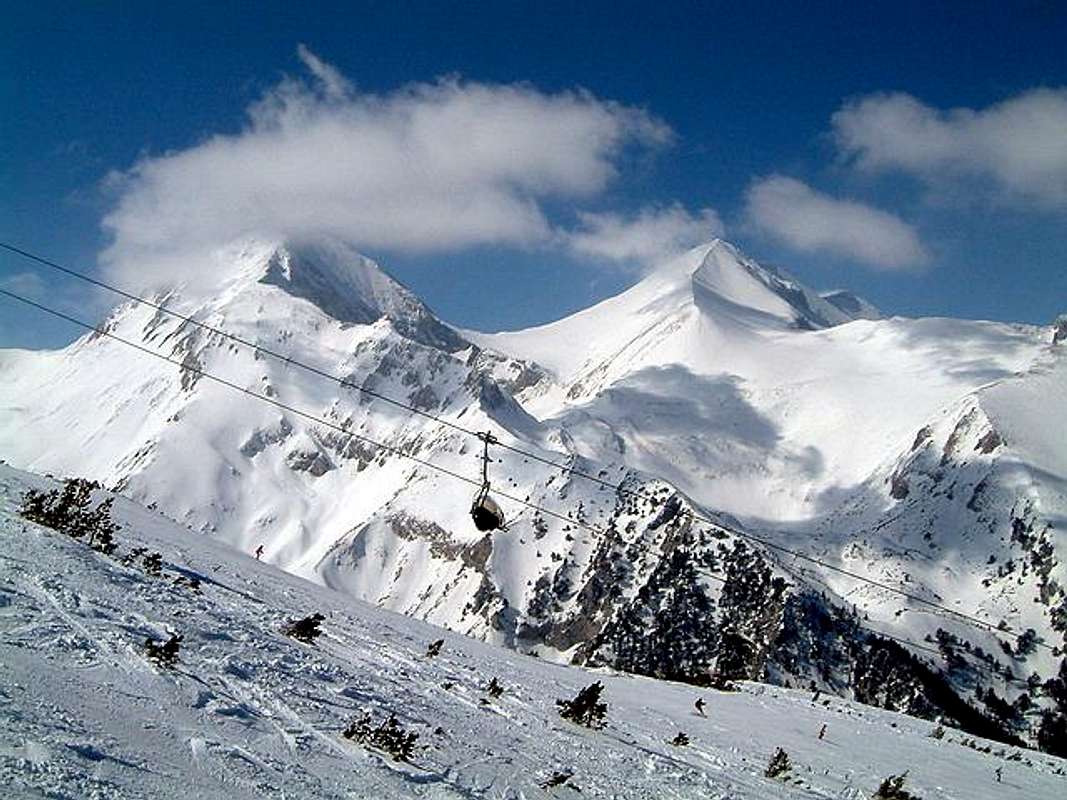
Pirin winter scenery
The skiing conditions in Bansko are excellent. The Pirin mountain has a predonantly Alpine charachter with three peaks towering above 2900 m. However the slopes offer runs and tracks for all types of skiers, from novice to the experts, while the ski runs are maintained in excellent condition. The town itself attracts visitors by its 120 cultural monuments, its museums houses, and the permanent ethnographic and Bansko schlool of icon painting exhibitions.
Bansko ski lifts:
The lifts and pistes in Bansko take care of your maximum comfort with their 8-man Gondola cable car by Doppelmayer, five 4 seat lifts of the latest Dopplemayer models, one 3- seat lift by Poma, 7 drags and 10 baby drags. The easy access to al lifts is secured by chip cards from SkiData.
A new 8- seat lift- gondola “Dopelmaier” started working last season. It is over 6 kilometers long and connects the town with Banderishka meadow. When one gets on it, he feels the incredible feeling that he is flowing over the snow slopes of Pirin towards the heart of the mountain. You can leave your car on the parking on the start station of the lift. The resort posses 26 kilometers ski- lifts with personnel, that help the skiers. The card for all the equipment is without contact, it is placed on the left side of the jacket, and when the skier passes, he do not have to take it out. Two new four seat lifts- from Banderishki to Kolarski road and from Zelezniq Bridge to Platoto. Drag- lift that is serving the right part of “Alberto Tomba” slope for beginners, which open Alberto Tomba (former Worlks Ski Champion) personally.
 |
 |
 |
Routes Overview
VIHREN (2914 m)
1. Southern approach: Vihren Hut – Vihren Southern Pass – Vihren (2914 m) summit: 3h
2. Northern approach: Vihren Hut – Vihren/Kutelo saddle – Vihren (2914 m) summit: 3.15h - 3.45h
3. Koncheto Shelter approach: Koncheto Shelter (2850 m) - Koncheto ridge (2850 m - 2900 m) - Kutelo (2908 m) summit - Vihren/Kutelo saddle (2600 m) - Vihren (2914 m) summit: 2.5h - 3h
KUTELO (2908 m)
1. Eastern approach: Vihren Hut (1950 m) – Vihren/Kutelo saddle (2600 m) – Kutelo (2908 m) summit: 4h
2. Koncheto Shelter approach: Koncheto Shelter (2850 m) - Koncheto ridge (2850 m - 2900 m) - Banski Suhodol (2884 m) summit - Kutelo (2908 m) summit: 1.30h - 2h
3. Eastern approach via Vihren summit: Vihren Hut (1950 m) - Vihren Southern Pass - Vihren (2914 m) summit - Kutelo/Vihren Saddle (2600 m) - Kutelo II (2906 m) - Kutelo I (2908 m): 5h - 5.30h
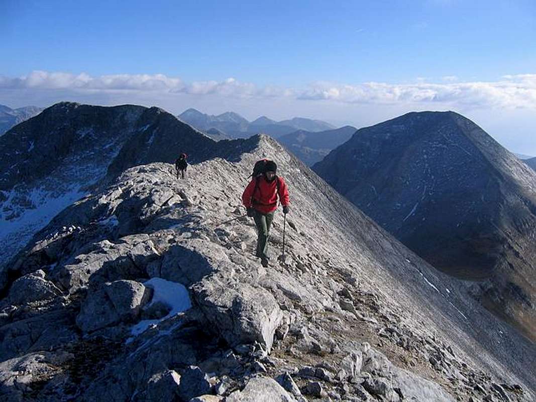
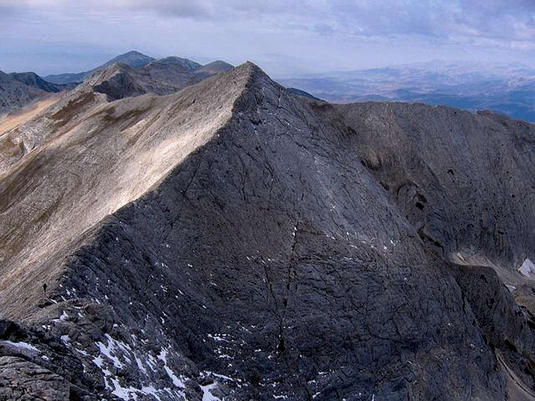
On Kutelo ridge
TODORKA
1. Southern (classical) approach: Vihren Hut (1950 m) - Hvoinato Ezero - Ribno Ezero - Banderishki Ezeri - Todorina Porta (2702 m) - Malka Todorka (2712 m) - Todorin Vrh (2746 m): 3.30h - 4h
2. Northern approach: Shiligarnika - Ski Chair Lift Hut (2500 m) - Todorin Vrh (2746 m) - Malka Todorka (2712 m) - Todorina Porta (2702 m): 3.30h - 4h
 |
 |
 |
Getting There
Gateway to Pirin National Park is Bansko (936 m) town. Height of resort - 936m, Height of ski runs 1100-2500m, Highest ski point - 2500m, Marked ski runs - 14km, Longest ski run - 2.6km
Look Bansko Webcam!
By plane:
To Sofia Airport, Sofia town - capital of Bulgaria. Information about flights to Sofia on Balkan Bulgarian Airlines.
By train:
To Sofia. Than from Sofia to Blagoevgrad, which is located near Bansko town. From Blagoevgrad to Bansko by local bus.
Information about train on Bulgarian Railway timetable. Combine Sofia - Blagoevgrad. Approximately time of this train distance: 2:30 h - 2:45 h.
By bus:
Sofia - Radomir - Dupnica - Bansko
informations about bus lines and tickets.
By car:
Sofia - Radomir - Dupnica - Bansko
From the capital Sofia, go South towards BLAGOEVGRAD, then west towards BANSKO. Bansko is great place to be - a resort city just where the mountain starts, with many authentic old-style bulgarian houses (150+ years), local taverns, etc.
From there one can either take the gondola-lift to the SHILIGARNIKA area (1800m), or start hiking on foot.
Shiligarnika is the local ski-center; one can enjoy perfect skiing in the winter, or just start its' trip in Pirin.
 |
 |
When To Climb
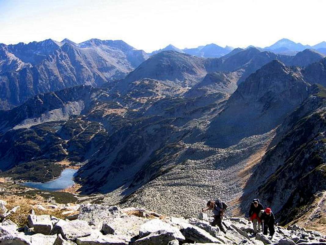
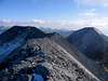
On Todorka ridge
Accessible through the whole year; great ski resort(s) in the winter.
Peaks of Pirin massif you can climb during whole year, but of course, the optimal period is from mid June - mid September, out of the season of snow on the mountain.
On sone very clear days, on can see as far as the Mt. Olympos in Greece , which is some 300km south.
 |
Camping
Camping is allowed, except in the preserved areas.
Many huts and shelters, price per night approx 3-6EUR.
You can stay in private appartments and rooms in Bansko town, which is 18 km far from the Vihren Hut (1950 m), or you can stay directlly in Vihren Hut, belowe eastern side of Vihren massif. Vihren Hut is optimal place for Vihren (2914 m) and Kutelo (2908 m) climbing routes.
Inside of Pirin massif exist few huts and shelters:
1. Vihren Hut
2. Yavorov Hut
3. Tevno Ezero Shelter
4. Kamenica Hut
5. Pirin Hut
6. Koncheto Shelter
The basic hike started: Razlog - Iavorov Hut (big,well-maintained,5DM/night) - Konceto Shelter (2760 m,with blankets,good beds,yet very narrow) - Konceto ridge (sharp ridge with steep walls underneath) - Vihren Summit (2914 m) - Vihren Hut (1950 m) (big, well maintained also) - Tavni Ezero Hut (free,as it was winter and there was no hut master) - Kamenitza Peak (sharp,very picturesque) - Kamenitza Hut.
Only huts (like the Javorov, the Banderica or the Pirin Hut) close to civilisation might be guarded in winter time.
 |
 |
Mountain Conditions
1. 10 day WeatherOnline forecast for Vihren (2914 m) area - look for Sandanski - town at the foot of the Pirin.
2. 6 day Bansko Forecast.
 |
Maps
Pirin Map - 1:55000
Editor: Kartografia EOOD Sofia, 1998.
 |
 |
 |
Red Tape
No fees required.
No permits needed either.
Usual rules of behaviour for NP's do apply.
Medical insurance is reccomended though, can be made in the city of Bansko.
 |
External Links
- Pirin National Park website
- Pirin - chaletes and shelters
short description and actual information about all chaletes and shelters located in the Pirin mountains - Bulgaria 2004
Trekking to Pirin Mountain, Peak Vihren 2914m and to Vitosha Mountain 2290m
Tarambuka3500 - Sep 26, 2005 10:27 am - Hasn't voted
Untitled Commentdido2 - Aug 15, 2010 6:11 am - Hasn't voted
About campingThe Camping section should be corrected as no wild camping is allowed within the Pirin national park boundaries, with a single exception. This is the camping site near "Bunderica" refuge, which is free of charge. There are in total 19 refuges in Pirin. Here's some recent status (2010) about the existing accomodation: 1. "Predel" refuge - 30 beds, fee is ~5-7 EU, rarely visited 2. "Yavorov" refuge - 100 beds, fee is ~5-7 EU 3. "Bunderica" refuge - 230 beds, fee is ~5-10 EU 4. "Vihren" refuge - 120 beds, fee is ~5-7 EU, under construction 5. "Demyanica" refuge - 217 beds, fee is ~5-7 EU 6. "Bezbog" refuge - 100 beds, fee is ~5-40 EU, somehow more luxury conditions there 7. "Goce Delchev" refuge - 150 beds, fee is ~5-7 EU 8. "Lagera" refuge - 50 beds, fee is ~5-7 EU, rarely visited 9. "Begovica" refuge - 180 beds, fee is ~5-15 EU 10."Pirin" refuge - 80 beds, fee is ~5-7 EU 11."Malina" refuge - 70 beds, fee is ~5-7 EU, rarely visited 12."Mocharata" refuge - 160 beds, fee is ~5-7 EU 13."Popovi livadi" refuge - 50 beds, fee is ~5-7 EU, rarely visited 14. "Yane Sandanski" refuge - 70 beds, fee is ~5-15 EU 15. "Koncheto" shelter - 10 beds, sleep there only on emergencies 16. "El-tepe (Kazana)" shelter - 4 beds, sleep there only on emergencies 17. "Sinanica" shelter - 50 beds, personnel only during the summer months. Fee is ~5-7 EU and free in the winter most of the time (when there is no personnel in the shelter) 18. "Spano pole" shelter - 20 beds, personnel only during the summer months. Fee is ~5-7 EU and free in the winter most of the time (when there is no personnel in the shelter) 19. "Tevno ezero" shelter - 65 beds, personnel only during the summer months. Fee is ~5-7 EU and free in the winter. Regards, Dido
dido2 - Aug 15, 2010 6:19 am - Hasn't voted
Maps section - a GPS Map of PirinA GPS map (Garmin-compatible) for Pirin and most of the popular mountains in Bulgaria is available at http://bgmountains.org/en/maps/category/4 . Please always download the latest version as the mapset is under constant development.