
|
|
Mountain/Rock |
|---|---|
|
|
46.59340°N / 121.841°W |
|
|
Hiking |
|
|
Spring, Summer, Fall |
|
|
5442 ft / 1659 m |
|
|
This page is up for adoption
I have decided to open up my Washington State pages for adoption to those who have been to the summit of the mountain and have a interest in maintaining and updating the page. Contact me via messenger if you are interested.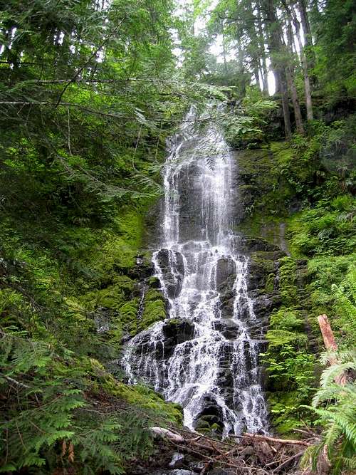 Davis Creek Falls
Overview
 What's atop Purcell Mtn
When Paul Klenke put up his page dedicated to the prominence peaks of the state of Washington, an amazing task to attempt, let alone climb them, I remembered that I had hiked up Purcell Mountain because it was a prominence peak and for no real other reason. Therefore, it is timely to put this page up to make the information available that will aid others that might be interested in doing the prominence peaks of our fair state. This one is easy to do but many on that list that Paul has put together are hard, much harder. So, with that bit of intro, on to the mountain of Purcell.
Purcell Mountain is an easy hike that is not far from Randle and Packwood Washington. This is the mountain to do when you want to combine it with nearby Huffaker Mtn. or Goat Mtn, just north of Mt. St. Helens. Purcell Mtn. was the site of a lookout at one time, demolished in the mid 1950's
when the forest service began to eliminate lookouts they no longer needed. The cement pillars still remain as does broken glass and rusty nails so the summit is not pristine by any means. Logged areas are readily visible from the summit which is a bit of a bummer but on a clear day Purcell gives the hiker a killer view of Mt. Rainier and that makes the hike worthwhile. Purcell is listed as one of the hikes in the "100 Hikes" series of Mountaineer Press books, the one dealing with the south cascades. Thanks to the increasing popularity of prominence peaks in Washington state, this mountain is becoming a bit more popular mountain to hike since it is one of Washington's prominence peaks. It is ranked 104 on the list as shown on the neat page by Paul Klenke. Purcell Mountain's lookout was abandoned in the 1950's according to Ray Kresek's book "Fire Lookouts of the Northwest" and was originally built in 1937. The lookout was once called "Trails End" and was reached by a trail that came all the way up from highway 12 but that trail is no longer available due to private property issues that have blocked access from the lower location.
Purcell Mtn is in an area that was logged relatively heavily and from the summit of Purcell you can see large areas that were logged at one time or are still being logged. Logging roads wrap around the east, north and west side of Purcell and you can see the impact that logging (very important to the local economy) has had on the area. I'm not badmouthing logging, it is part of the history of the northwest and one of the reasons we have roads that allow access to so many parts of our mountains.
Getting There
Update: The access listed below is now outdated. See the information provided by Dundeel and Eric Noel at this link.From Seattle or Portland, take I-5 to US highway 12, exit 68, and follow the signs to Morton and then to Randle. Drive 5-6 miles from Randle to a road on the left marked Davis Creek Road which at one time used to be part of the old highway. Drive paved road almost a mile to just short of the concrete bridge and enter unpaved FS Road #63 on the left.I don't recall a sign indicating the road number but it immediately goes uphill. At 0.7 miles from the paved road you cross a bridge that spans Davis Creek Canyon and continue heading up the road. It is roughly 4.5 miles overall from the paved road to a spot where you should park on the right hand side of the road, room enough for two or three vehicles at least,
 TH for Purcell Mtn trail
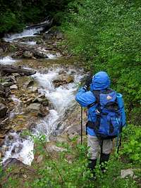
You can also approach Davis Creek road from Packwood (about ten miles)and look for the Davis Creek road as it heads off to the right from US 12. Then drive until the concrete bridge mentioned earlier and after crossing the bridge at Davis Creek, turn immediately to the right on FR 63.
Three routes:
The Purcell Mtn. trail which is now posted and (2), the other via a road which is shorter in total hiking distance and elevation gain via logging roads on the northside of the peak but it wasn't available to us thanks to a huge tree blocking the road which kept us from going that way. Paul Klenke has gone via the shorter hiking route and found it a great way to access the summit. Road FR 63 continues up to this point where you can take FR 102 around the northside to a point where Paul mentions it is bermed. From that bermed spot where he parked, he walked up the road to this spot and hiked up from there. Check out Paul's Whalehead Ridge page and scroll down to his description of "the approach from Davis Creek". It gives the directions you need for his approach to the route he used for Purcell.
Andy Boos shares this route that he used to access the mountain:
"There's a labyrinth of Forest Service roads in the Purcell Mtn. area, along with several flood-related closures. I was able to drive to about 4000' on Road 4730, about 1.5 miles NE of Purcell, and from there it was a reasonably easy cross-country route, with a little road-walking thrown in, that took me maybe 90 minutes to reach the top. See the attached map.
Probably the best way to reach Road 4730 would be to drive past Ashford on Highway 706, then take Skate Creek Road (FS Road 52) toward Packwood. This is a paved road. Go most of the way toward Packwood, turning off right on FS Road 47. I don't know the exact mileages. Once you're on Road 47, I trust you can find your way to Road 4730 and reach the point where I parked. Road 4730 is a bit rough, with some eroded ruts in places. I have a Ford Ranger (2WD) with decent clearance, and didn't have any difficulties. I think a sedan would make it OK, but I wouldn't guarantee that."
Red Tape and FS information
None that I am aware of. No forest service pass was required at the time of our visit and probably never will be.
Cowlitz Valley
Ranger District
10024 US Hwy 12
PO Box 670
Randle, WA 98377
(360) 497-1100
Call the ranger station mon-fri from 8:30 to 4:30 to get current information.
about the condition of road FR 63.
Camping
You could probably camp at where you park your vehicle but that would be only if you slept in your vehicle as there is no room for tents at that spot.Not far from Randle are several campgrounds I can recommend the Iron Creek Campground as a nice place to camp.
The weather report
Weather report for Randle Washington, Click HERE or on the banner below
Davis Creek Waterfall
About 3 miles up FR 63, on the right side of the road is a hidden
. For more information, check out Bryan Swan's great page HERE.

Update alert
Eric Noel posted this information from a recent attempt to get up Purcell. I'll put it here in its entirety:"Davis Creek Road...Washed out at Davis Creek.
Little Concrete Bridge...Washed out at Davis Creek.
FS 47...Washed out at East Fork Silver Creek. You can go way around via 52->47 in about 40 miles but...
FS 63...Washed out at 3000' at Unnamed Creek.
The shortest option is probably hiking from Klenke's route via the washout on FS 63 on the north side of Purcell. Now, 47 has to be accessed via 52 from the SE or 84/85 from the NE as it is blown out on the west side of Purcell. I would guess 15 miles with 2500 feet of gain with it being mostly a roadwalk. Much more gain if you come in from the south at present. No wonder houses were floating away on the Cowlitz. I can't see the washout on FS 47 or FS 63 on the north side of Purcell being fixed soon if ever. Best bet is to go Klenke's way, maybe with a bike, or else wait for the southern approach to be fixed as there are houses around there so it is most likely to get help."
This was posted on 8-10-07 For those of you who hadn't heard, a devastating winter rain storm did a lot of damage in the Mt. Rainier area.
It obviously damaged more than most of us realized.
ericnoel - Aug 11, 2007 9:38 pm - Voted 10/10
You can't get there from here.Davis Creek Road...Washed out at Davis Creek. Little Concrete Bridge...Washed out at Davis Creek. FS 47...Washed out at East Fork Silver Creek. You can go way around via 52->47 in about 40 miles but... FS 63...Washed out at 3000' at Unnamed Creek. The shortest option is probably hiking from Klenke's route via the washout on FS 63 on the north side of Purcell. Now, 47 has to be accessed via 52 from the SE or 84/85 from the NE as it is blown out on the west side of Purcell. I would guess 15 miles with 2500 feet of gain with it being mostly a roadwalk. Much more gain if you come in from the south at present. No wonder houses were floating away on the Cowlitz. I can't see the washout on FS 47 or FS 63 on the north side of Purcell being fixed soon if ever. Best bet is to go Klenke's way, maybe with a bike, or else wait for the southern approach to be fixed as there are houses around there so it is most likely to get help. :-(
Dean - Aug 11, 2007 10:23 pm - Hasn't voted
Re: You can't get there from here.Good grief, that bridge is gone too? That really stinks. So now you can't even get to the trailhead or up to Davis Creek Falls. Thanks for the info, I'll put it on the front page and post it as an alert. : (
ridgeguy - Jul 19, 2012 3:47 am - Hasn't voted
2012Davis Creek Road all good now. See trip report link in register section. July/2012