Niedere Tauern range is far too complex to remain just one area on SummitPost. As it is usually divided on four main mountain groups, we can describe them separately. I have only a limited personal experience with Radstaedter Tauern, so please contribute information!
Radstaedter Tauern group is the westernmost group of Niedere Tauern. On the west its border is Grossarltal, running from Sankt Johann towards the south and later southeast. As the valley rises, it approaches the range of Hohe Tauern on the south. The border between Niedere Tauern (Radstaedter Tauern) and Hohe Tauern lies on Murtoerl, 2260 m. East of Murtoerl, there is the upper valley of Mur river, representing border between Hohe Tauern on the south and Radstaedter Tauern on the north. At first the river flows towards the east-southeast, when passing St. Michael, and thus leaving Radstaedter Tauern, it turns towards the east. At Mautendorf the Taurach creek comes down from Obertauern Pass, finally flowing into Mur river. Its valley, and the Obertauern pass itself (1739 m), is the eastern border of Radstaedter Tauern, delimiting our group from the rest of Niedere Tauern (east of the pass are first Schladminger Tauern). On the other side of Obertauern pass, first towards the west, then towards the north, another Taurach creek flows. Poor imagination of those people, who were not able to name two creeks, flowing in completely opposite directions with two distinct names. On the north, at Radstadt, this Taurach creek flows into Enns river. So, it represents the remainder of eastern border of our group. On the north, west of Radstadt, Enns is for short time the border of our group. But only till Altenmarkt, where it comes out of its source valley. Further to the west we have three small creeks representing the border: Litzlingbach, Schwaighofbach and Wagrainerbach, the latter finally flowing into Salzach river at Sankt Johann.
Liechtensteinklamm - also a nice geological example
Geology
Radstaedter Tauern are by their geological origin much different than the rest of Niedere Tauern. While the latter are mostly made of older, metamorphic rocks, Radstaedter Tauern are made of sedimentary rocks. In Mesozoic, in warm, shallow seas thick layers of sediments were deposited. But the sea, where the sediments of Radstaedter Tauern were formed, was at that time much northwards, even north of the sea in which huge masses of Dachstein kalk were created. Yes, mountains are travelling too, and that is why today Radstaedter Tauern limestone massif is situated southwest of Dachstein. Immense natural forces pushed the limestone layers over younger slate rock structures, which were on present locations created in younger periods of Mesozoic. Clear evidence of that drift can be seen south of Obertauern pass, in Pleißlingkeil subgroup (for example Schwarze Wand). When from the depths of Earth crust Hohe Tauern started to rise, those pressures additionally impacted the rocks of Radstaedter Tauern. That is why on some places they are even slightly metamorphous. Geological origin impacts the look of Radstaedter Tauern today. On slate layers, which are on some places seen up to mountain tops, on most of higher mountains we can see rugged, sharp rocks of limestone and dolomitic sedimentary rocks, which gives to the mountains of our group their wild and attractive look. However the limestone layers are mostly not thick and compact enough, so that high walls, suitable for long climbing routes, would be created. Mountains are often crumbly, but still very suitable for hiking and scrambling. In some areas, mostly north of Mosermandl, there are high carst plateaus, suitable for ski treks.
Radstaedter Tauern are in some places highly touristically developed, but in other places you will find high mountains where, except rare locals, nobody goes. On the northern part, we have broad mountaneous areas, opened for massive ski tourism. Ski Amade ticket is covering one of the broadest ski areas in Europe. Everyone knows ski centers like: Flachau, Zacuhensee, Obertauern, Wagrain and Sankt Johann. Where artificially arranged terrains end, the terrains for tour skiing begin. They are very nice as well. The western range (between Gross and Kleinarltal, mountains south and southwest of Tappenkarsee, mountains above Mosermandl plateau, the area around Weisseck, with the highest summit included, Grosser Pleisslingkeil and the surroundings, and many more summits are just great for tour skiing. When skiing season is over, hiking season begins. But the network of marked paths is dense only is some areas. As said, there are remote mountains which can be reached by scrambling or even easy hiking, but almost nobody goes there. Most of good, marked paths can be found on the northern side of the massif and also along the main backbone - from Obertauern pass to Murtoerl. Some high valleys and mountain roads can also offer you nice biking tours, or, at least a bike support for hiking tours. More about hiking goals will be said by each subgroup.
Getting There
Through Zedehausbach valley the highway goes. Left is the lonesome Hochfeind ridge.
On the above Google map you can see the main parking places. So, you can drive through the valleys which lead to them and reach trailheads at the end of Grossarltal, Kleinarltal, Zauchensee, mid valley above Zederhaus, upper valley of Mur. Obertauern pass is a very suitable trailhead too. Or, of course, you can start a tour down in those valleys, before reaching the end parking place. The main access to the Radstaedter Tauern mountain area is of course the Villach-Salzburg highway (Tauern Autobahn). From above Zederhaus on the south, to the sources of Enns on the north, a big tunnel (payable) goes through Radstaedter Tauern. You can exit the highway either near St. Michael on the south, or at the north exit, in Enns (Flachau) valley. Online map: http://www.austrianmap.at
Subgroups
Even the group of Radstaedter Tauern is big enough to divide it into a few subgroups. As there are too many distinct mountains, only the most interesting will be mentioned. On the map above, red are the mountains which already have their SummiPost page.
Draugstein from the southeast
Western Ridge
These are the mountains in the range, dividing Grossarltal and Kleinarltal. On the north they start with hills below 2000 m of altitude, which are due to nice panorama still attractive to visit. Even more as they are easily reachable, because cable cars and mountain roads are almost reaching their tops. The summit of Gabel, 2037 m, is first exceeding 2000 m. South of it, we have in the main ridge Penkkopf, 2011 m, and Grundeck, 2168 m. Over these summits a marked path goes all the time. More towards the south, the marked path avoids the two summits in the main ridge: Nebeleck, 2158 m, and Gamskoepfl, 2160 m. Next summit is the most attractive peak in the Western ridge: Draugstein, 2358 m. In this area, in the side ridges of Draugstein there are also high summits, but marked paths are reaching only the western ones. On Draugstein itself, a steep, quite difficult, but partially protected hiking route (UIAA I degree) goes over the summit rocks, 1 h. Also to the east of Draugstein, there are rocky, rugged, limestone summits. South on this small limestone group, on Draugsteintoerl, the main ridge continues over a few humble, slate summits (Karteiskopf, 2203 m, Gurenstein, 2219 m, Kreuzeck, 2204 m), and then rises considerably on the nice, sharp Glingspitze, 2433 m (nice goal for tour skiing too). From it, the ridge runs towards the southeast on Nebelkareck, 2535 m, and finally descends on Murtoerl.
In the northern part of this group we have a long ridge, rising between Kleinarltal and the valley of Enns source. The first summits are hosting Flachau and Wagrain ski terrains, then marked paths go by the main ridge on the nearby Griessenkareck, 1991 m, from it on Saukarkopf, 2014 m, and further to the south. The first really attractive summit then is Ennskraxen, 2410 m, 3 h 30 min. While marked path reaches this one, its higher south neighbour Kraxenkogel, 2436 m, is harder to reach (climbing UIAA I difficulty, brittle rocks). Then a high, pathless ridge continues over many summits towards the south. There, with Faulkogel, 2654 m, the most beautiful part of Radstaedter Tauern begins. The summit of Faulkogel can be reached by a quite difficult, marked path by the north ridge (3 h 30 min from Franz-Fischer-Huette, 4 h 30 min from Flachau. In the wild Faulkogel group, more towards the south the following summits are rising: Rothorn, 2522 m, Wildkarhoehe, 2511 m, Stierkarkopf, 2366 m, Wildkarkopf, 2379 m, Weissgruubenkopf, 2369 m, and Schiereck, 2365 m. Only Stierkarkopf and Weissgruubenkopf are reached by marked paths, but some other paths are crossing the high saddles. West of the highest mountains of Faulkogel group, on 1762 m peacefully lies the nice Tappenkarsee, a very worthwile goal of a hike itself.
Faulkogel group and Tappenkarsee from the west
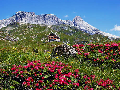
The described ridge, going in the north-south direction, represents only the western part of Mosermandl group. Just southeast below Faulkogel, on Windischscharte, 2304 m, the main ridge of Mosermandl starts, going in the eastern direction. After the broad Windischkopf, 2609 m, it culminates in the sharp Mosermandl, 2680 m. Two quite demanding marked paths (climbing UIAA I degree) reach its top. Towards the east high mountains continue. The first one is Klein Mosermandl, 2538 m, then Schliererspitz, 2402 m, finally Permuthwand, 2479 m. No marked path reaches these summits, they go only across their slopes. North of Mosermandl group there is a broad high karst plateau, above which many summits, higher than 2000 meters are rising. They are rarely visited, but paths, ascending from the north on the plateau, are going close to many of them.
Steinfeldspitze E ridge
Steinfeldspitze view (SW)
Zauchensee Group
The valley of Zauchenbach, ending with the touristically well developed area of Zauchensee is surrounded by a wreath of mountains, many of them exceeding 2000 m. It is a very nice and panoramic horseshoe. Some of the summits are being reached by cable cars, but along the whole horseshoe also a marked path goes, enabling a nice, long trek, on which you can collect some 12 summits. The path is mostly easy, more difficult (in a hiking sense) is only a section close to the highest summits (airy, climbing UIAA I degree). The highlights of Zacuhensee horseshoe are the summits: Tagweidegg, 2135 m, Schwarzkopf, 2263 m, and the highest one - Steinfeldspitze, 2344 m. In the eastern branch, let's mention only Strimskogel, 2139 m.
Pleisslingkeil group from across Obertauern pass
Pleisslingkeil Group
This is the eastern continuation of Mosermandl Group, representing thus the main crest of Niedere Tauern, going on Obertauern pass. From Zauchensee Group it is delimited by a broad saddle, where Suedwiener Huette stands, 1801 m, the border with Mosermandl group is on the high Taferlscharte, 2236 m, and on the broad saddle 2117 m, northeast of it. Going from the west, after a few foresummits the ridge immediately culminates in Kleiner (2417 m) and Grosser Pleisslingkeil, 2501 m. The latter is a nice hiking goal, but an also well desired tour skiing goal. Its northern slopes are steep, but fine, other faces are sheer drops and offer no chance for skiing or hiking. Towards the east, a marked, but not just trivial path, crosses the whole group It first visits Hintere Grosswandspitze, 2437 m, then goes below Gloecknerin, 2433 m, ascends Zehnerkarspitze, 2382 m, and Gamsspitzl, 2340 m, and finally descends to Obertauernpass. Those are all nice, rugged summits, nice place to visit is also Wildsee, north of them.
Weisseck from the north
Riedingspitze
Weisseck Ridge
The highest mountain of Radstaedter Tauern stands on the very northwest of a long ridge, continuing then far down towards the southeast. So, the ridge stretches between the valleys of Mur on the southwest and Zederhausbach on the northeast. The upper part of the latter is the nice valley of Riedingbach (Riedingtal), half encircling the highest summit. After a short ridge, coming from the west, the real Weisseck group starts on Riedingscharte, 2274 m, connecting Riedingtal and Murtal. Just east of the saddle, Weisseck, 2711 m is already rising. The west ridge is also the easy, normal approach on it. Weisseck is also one of the greatest goals of ski tours. West ridge is easy again, but in good spring conditions the most rewarding ski tour goes towards the north, through Oedenkar. Before continuing by the main ridge, let's mention also the picturesque Riedingspitze, 2266 m, above the end of Riedingtal. From Weisseck, the main ridge goes over many high summits towards the southeast. It is completely pathless, no summit is reached by a marked path, a real "terra incognita". So, let's name only a few main summits: Plankowitzspitze, 2412 m, Pleissnitzkogel, 2536 m, Marislwand, 2529 m, and Grosseck, 2427 m.
Hochfeind Group
Hochfeind group from the south
This is a very similar mountain ridge to the previous one. It goes paralelly to it in the same direction (so between Zederhausbach valley and Taurach valley), is also very high and very rarely visited. But at least some of its summits are being reached by marked paths. Otherwise, crossing the whole ridge requires on some places easy climbing of UIAA II degree, the tour is very long but supposedly also quite rewarding. The ridge starts on Taferlscharte, 2236 m. The first part of it to Hochfeind, 2687 m, is pathless. Further to the southeast the summit of Schwarzeck, 2636 m, is reached by a marked path from the south. Another marked path comes on the ridge from the north, and reaches close to the next high summit, Weisseneck, 2563 m. Then the marked path continues all the time by the main ridge, crossing the summits: Schareck, 2466 m, Kaempenkoepfeln, 2366 m, and Speiereck, 2411 m. The latter is almost reached by a cable cars system (from St. Michael and Mauterndorf), but in summer may be you can not rely to use it for the descent - it operates mostly in winter.
Mountain Huts
In the area you can find many huts on alpine pastures, where you may get perahps also food and drink, but mountaineering is supported by the following huts, where you can also find accomodation:
Zauner SeeSüdwiener Hütte, 1802 m. On a broad saddle between Zauchensee Group and Pleisslingkeil Group. 1 h 30 min from Gnadenbruecke in Taurachtal.
Franz Fischer Hütte, 2001 m. Stands above the nice Zaunersee, between Mosermandl Group and Faulkogel Group. 1 h 15 min from Riedingtal (toll to drive there)
Stickler Hütte, 1752 m. Stands in the upper Mur valley. It can be reached on foot (1 h), by bike or by valley bus.
Speiereck Hütte, 2074 m. Stands on a below the summit of Speiereck. Chair-lift from St. Mihael, otherwise 3 h on foot.
Tappenkarsee Hütte, 1820 m. Stands above the lake with the same name. 2 h 30 min walk from Schwabalm (end of Kleinarltal).
Draugstein Hütte, 1714 m. Stands south of Draugstein summit. 1 h 15 min from the parking place on Halmoos Alm (Karteis region).
Kleinarler Hütte, 1754 m. Stands close to the main Western Ridge, below the summit of Penkkopf, 2011 m. 2 h 30 min from Kleinarl.
Red Tape
In the area of Radstaedter Tauern there are no special restrictions. Many mountain roads are closed for public traffic. Tauern Tunnel (on Salzburg-Villach highway) must be paid (additionally to the Austrian vignette).
Children refers to the set of objects that logically fall under a given object. For example, the
Aconcagua mountain page is a child of the 'Aconcagua Group' and the 'Seven Summits.' The
Aconcagua mountain itself has many routes, photos, and trip reports as children.
Parents refers to a larger category under which an object falls. For example, theAconcagua mountain page has the 'Aconcagua Group' and the 'Seven Summits' asparents and is a parent itself to many routes, photos, and Trip Reports.

 5284 Hits
 85.36% Score
 20 Votes
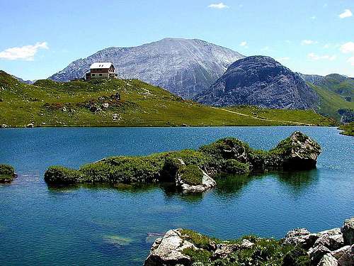
 Mosermandl is in the heart of Radstaedter Tauern
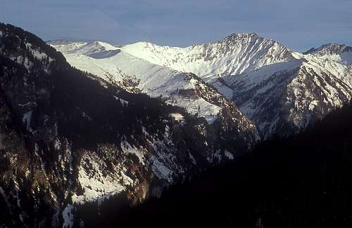 Mathias Zehring - Glingspitze from the WNW
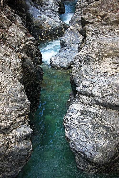 Liechtensteinklamm - also a nice geological example
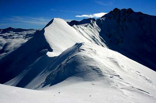 Michael Prittwitz - Tour skiing on Glingspitze
 Through Zedehausbach valley the highway goes. Left is the lonesome Hochfeind ridge.
 Draugstein from the southeast
 schmid th - Ennskraxen
 Faulkogel from the S
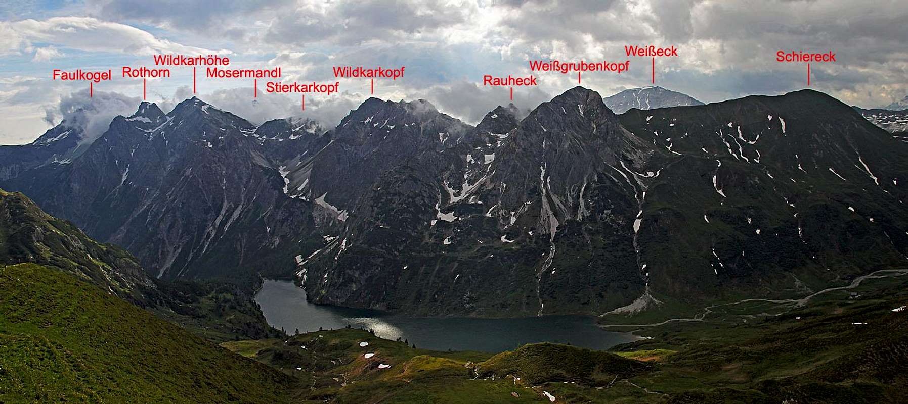 Faulkogel group and Tappenkarsee from the west
 Steinfeldspitze E ridge
 Steinfeldspitze view (SW)
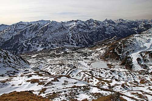 Pleisslingkeil group from across Obertauern pass
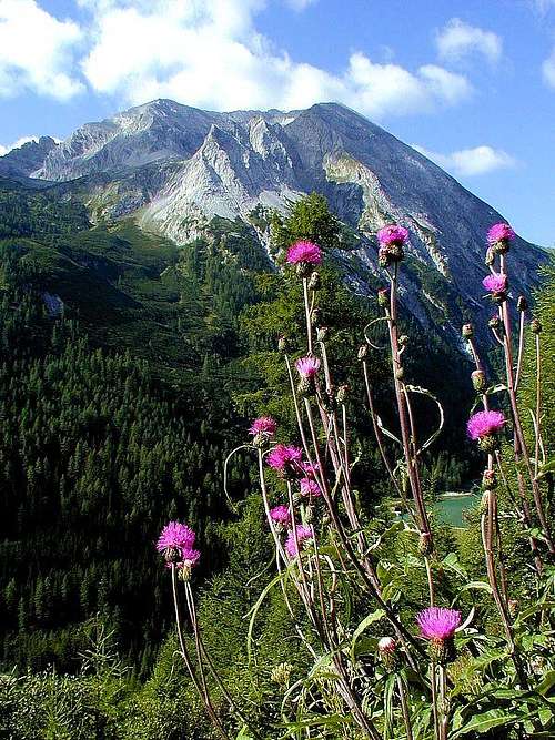 Weisseck from the north
 Riedingspitze
 Hochfeind group from the south